11% of Havre de Grace’s homes were built before 1940
More historic than 84% of U.S. towns · #25 of 261 in Maryland. What drives it
6 places in town are on the National Register, among them the Sion Hill, a National Historic Landmark, and two historic districts with 905 buildings between them. Below: 22 old photos and papers, maps from 1885 on, and the census since 1850.
On its age, its old homes and the National Register, Havre de Grace is more historic than 84% of U.S. towns, #25 of 261 in Maryland. Its National Register listings hold the grade up; its share of homes from before 1940 pulls it down.
A−
HistoryA character grade: shown, never part of Havre de Grace’s overall grade.
Few Maryland towns list much on the Register (a typical Maryland town has 0.9 per 10,000 residents, the U.S. 2.4), so Havre de Grace’s 608 sits above most of its state (91% of Maryland towns have fewer) while its 911 historic buildings outnumber those of 98% of U.S. towns.
How sure. Graded on two of the three inputs, so a change in either one moves the letter more than it would with three. The pre-1940 share (±2.5 points) is firm at this size.
Founding year: our sources. Homes: Census ACS 2020–24. National Register: National Park Service, May 2026 list; each listing counted once (boundary changes and added documentation belong to their listing), and a historic district counts its contributing buildings. How TownRatings grades history →
What stands out about Havre de Grace’s past
Read from the archive, the National Register and the record. The page puts what stands out first.
Nothing in the archives for these yearsWeddings on Main Street, storms, parades, school pictures, the old store. If it’s in your family album, it belongs here.
Fire insurance maps drew every building, what it was made of and what it was used for, so insurers could price the risk of fire. Pick a year, then a sheet.
During the Revolutionary War, the small hamlet known as Harmer's Town was visited several times by General Lafayette, who became considered a hero of the war. He commented that the area reminded him of the French seaport of Le Havre on the English Channel. It had originally been named Le Havre-de-Grâce. Inspired by Lafayette's comments, the residents incorporated the town as Havre de Grace in 1785.
George Washington stayed overnight in the town in 1789, on the journey to New York City for his first inauguration. During the First Congress in 1789, Havre de Grace missed by only one vote being named the capital of the fledgling United States.
Passages that mention Havre de Grace, cut from the printed page as they were published.
History of Harford County, Maryland1901 · page 154Read the page →
Read the text
brought here and buried at the east end of the church by the side of his wife. Rev. Mr. Handy seems to have been an assistant to Mr. Allen. He labored in the town of Havre de Grace, where a church has since been built. This, at a latter period, became an independent parish.
Text read by machine from the scan; it may contain errors.
HISTORY OF HARFORD COUNTY MARYLAND1901 · page 71Read the page →
Read the text
Governor), upon the petition of James Wilson, Samuel Hughes, Gabriel Christie, Mark Pringle, Gibson Denison, John Hall and John Lee Gibson, an act was passed “for making an addition to the town of Havre de Grace and to improve the navigation of the river Susquehanna and for other purposes.”
Text read by machine from the scan; it may contain errors.
HISTORY OF HARFORD COUNTY MARYLAND1901 · page 154Read the page →
Read the text
brought here and buried at the east end of the church by the side of his wife. Rev. Mr. Handy seems to have been an assistant to Mr. Allen. He labored in the town of Havre de Grace, where a church has since been built. This, at a latter period, became an independent parish.
Text read by machine from the scan; it may contain errors.
History of Harford County, Maryland1901 · page 254Read the page →
Read the text
June II. — The board met and ordered the constable of the town to "summon a sufficient number of the male inhabitants of the town of Havre de Grace to remove a nuisance accompanied by the fish troughs of Christian Hoopman, on the morning of the 12th of June instant, agreeable to the form of the Act of Assembly made and provided."
Text read by machine from the scan; it may contain errors.
Scans and text from the Internet Archive. Books published in 1930 or earlier, which are in the public domain.
Timeline
Havre de Grace, 1789 to 1999
Woven from the archive, old maps, post office records, the National Register and the people born here.
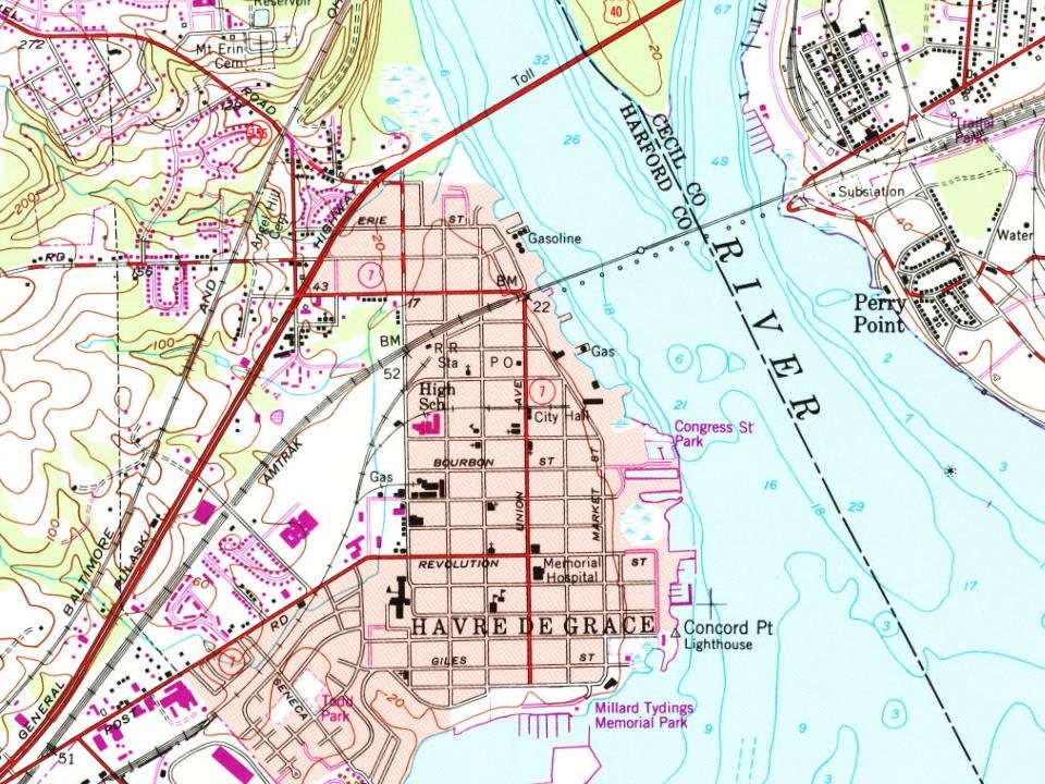
Every edition of the U.S. Geological Survey’s map of Havre de Grace. Tap a year, or press play to watch the town change.
1900Havre De Grace sheet · 1:62,500
U.S. Geological Survey historical topographic maps (public domain), via Esri’s collection of the scans. The red ring marks the center of Havre de Grace.
Then & now
Stand where they stood
No then-and-now pairs yet. Take a photo from the same spot as an old one and they appear here side by side.
Retake this viewThe Sons of Columbia. A national song. Written for the Fourth of July and set to music by Theodore Ascherfeld, Havre De…, 1850
Find the spot, match the angle, and add your photo. It becomes the first then-and-now pair on Havre de Grace’s page.
Havre de Grace is more historic than 84% of U.S. towns, #25 of 261 in Maryland. The History grade combines the town’s founding era, the share of homes built before 1940 and its National Register listings. It’s a character grade, so it isn’t part of the overall grade. How it works.
What is on the National Register in Havre de Grace?
6 listings: 2 buildings, among them the Sion Hill (a National Historic Landmark since 1992), 2 historic districts, the Southern Terminal, Susquehanna and Tidewater Canal and the Havre de Grace Historic District, with 905 contributing buildings, and 2 structures. 911 historic buildings in all.
How old are the homes in Havre de Grace?
11% of Havre de Grace’s homes were built before 1940 (Census estimate, ±2.5 points), against a typical 3.3% for a Maryland town; the median home was built in 1992.
Founding dates: Wikidata, Wikipedia, the U.S. post office records of Blevins & Helbock (CC0) and the Census. Homes by year built: Census ACS 2020–24. National Register of Historic Places: National Park Service (list of May 22, 2026). Old photos, postcards and papers: Wikimedia Commons, the Library of Congress and other public archives, credited on each item’s page. Maps: U.S. Geological Survey historical topographic maps (via Esri) and Sanborn fire-insurance maps (Library of Congress). History text and census tables: Wikipedia (CC BY-SA 4.0). Places that used to be: USGS Geographic Names Information System (2021).
From Wikimedia Commons (18), the Library of Congress (4), the National Register of Historic Places (6), Wikipedia, Wikidata and Wikipedia for famous people, U.S. Geological Survey historical maps, U.S. Census counts (via Wikipedia), the US Post Offices dataset (Blevins & Helbock), the USGS Geographic Names Information System, Sanborn fire insurance maps (Library of Congress) and old county and town histories (Internet Archive). Archive images are copied here with their credits and licenses, shown on each photo’s page. Refreshed monthly.


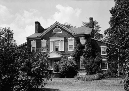 ★ Landmark


 c. 1811
 1812
 1850
 1860
 1860
 1860
 1892
 1892
 1897
 1907
 1910
 1917
 1917
 1917
 1917
 1920
 1920
 1920
 c. 1930
 c. 1930
 c. 1930
 c. 1930