Guest, Sign inJoin

Post to Whitinsville

We’ll email a one-tap link to publish your post. No password, and nothing is public until you click it.
Already a member? Sign in
Village of Whitinsville Historic District, Town of Northbridge, MassachusettsPhoto: Kenneth C. Zirkel · CC BY 4.0
–Not graded
History · Whitinsville

Whitinsville’s post office opened in 1835, and 37% of its homes were built before 1940

2 places in town are on the National Register. Below: 6 old photos and papers, maps from 1886 on, and old-book passages.

1835first post office
2on the National Register
37%homes built before 1940
6old photos & papers
8famous people
From Whitinsville’s archive · credits on each photo
Quick answers

How Whitinsville began

When was Whitinsville founded?

1835

The Whitinsville post office opened in 1835, the earliest record of the town by name.

2020 census: 6,750191 years
Founding year: the first Whitinsville post office (Blevins & Helbock, CC0).The full story ↓

What stands out about Whitinsville’s past

Read from the archive, the National Register and the record. The page puts what stands out first.

★ What stands out · On the map

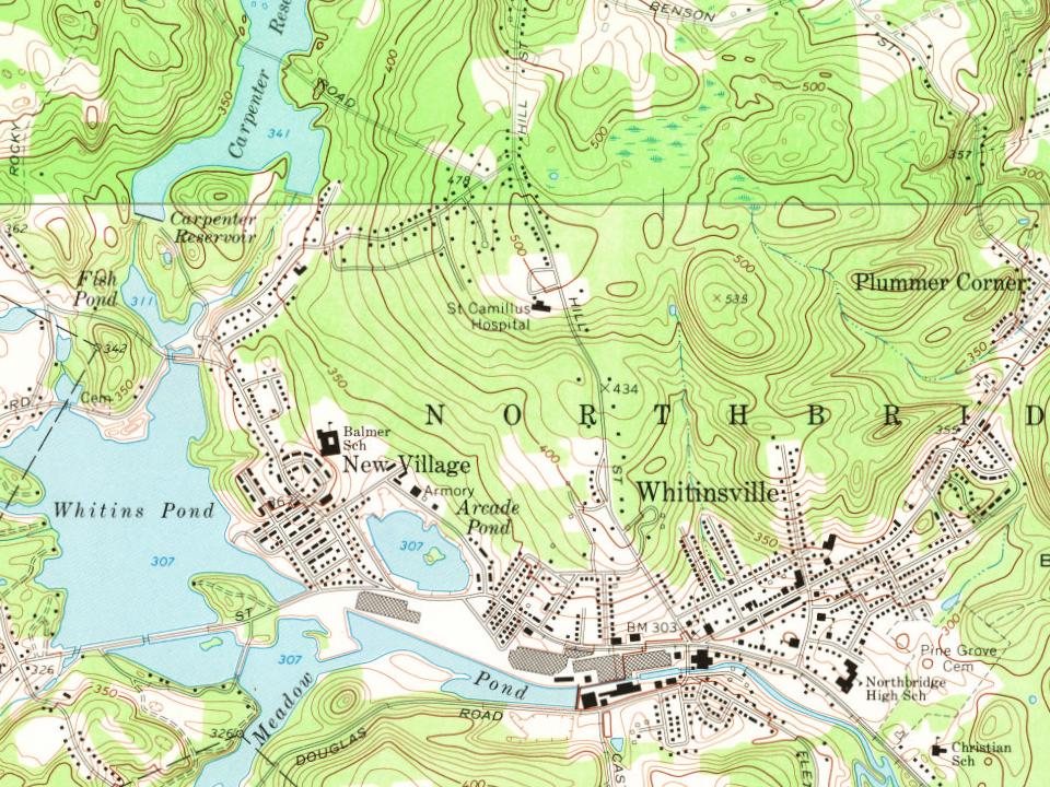
Whitinsville on the map, 1886 to 1982

Every edition of the U.S. Geological Survey’s map of Whitinsville. Tap a year, or press play to watch the town change.

Whitinsville on the 1886 USGS mapWhitinsville on the 1893 USGS mapWhitinsville on the 1900 USGS mapWhitinsville on the 1919 USGS mapWhitinsville on the 1953 USGS mapWhitinsville on the 1969 USGS mapWhitinsville on the 1979 USGS mapWhitinsville on the 1982 USGS map1886Blackstone sheet · 1:62,500

U.S. Geological Survey historical topographic maps (public domain), via Esri’s collection of the scans. The red ring marks the center of Whitinsville.

Every building

Whitinsville, building by building, 1903–1917

Fire insurance maps drew every building, what it was made of and what it was used for, so insurers could price the risk of fire. Pick a year, then a sheet.

Whitinsville fire insurance map, 1903, sheet 11903Sheet 1 of 5
Edition
BrickWoodStone

Sanborn Map Company, via the Library of Congress. Editions published in 1930 or earlier, which are in the public domain.

Timeline

Whitinsville, 1865 to 1981

Woven from the archive, old maps, post office records, the National Register and the people born here.

  1. 19th century
  2. 1865In the archiveGroup of elderly women and men on a porch, in Whitinsville
  3. 1880In the archive1950 Census Enumeration District Maps - Massachusetts (MA) - Worcester County - Whitinsvi…
  4. 1886On the mapFirst mapped by the U.S. Geological Survey
  5. 1891In the archiveUS-MA(1891) p387 WHITINSVILLE, WHITIN MACHINE WORKS
  6. 20th century
  7. 1913Born hereJoan McSheehy is born here
  8. 1920In the archiveChurch Street, Whitinsville, Massachusetts - 1920s postcard
  9. 1928Born hereJohn Kizirian is born here
  10. 1930Born hereVernon Ahmadjian is born here
  11. 1943Born herePhil Vandersea is born here
  12. 1981In the archiveGreek Revival - Northbridge (Whitinsville), MA - Whitin Mill Workers Housing (1)
The story

How Whitinsville came to be

From Wikipedia’s history of Whitinsville.

Read it all →

This village was originally Nipmuc native lands, and was first settled as part of Mendon in 1662. From 1662 to 1727 it was part of Mendon, then later it became part of Uxbridge from 1727 to 1772. In 1772 Northbridge finally became a separate town. The village's early name was "South Northbridge", before the Whitin family's rise to prominence. Col. John Spring led a militia training company from Uxbridge which fought in the American Revolution. Col. Spring was from the section that became South Northbridge.

Text from Wikipedia, licensed CC BY-SA 4.0.

From the old history books

What they wrote about Whitinsville, 1879–1907

Passages that mention Whitinsville, cut from the printed page as they were published.

Whitin took the machine manufacturing; Charles P. Whitin took the cottonmill in Whitinsville, and James Whilin took the unimproved privilege at Linwood, near the railroad station, in addition to the mills at North Uxbridge. The amount of work done in each of these establishments is very extensive. …
History of Worcester County, Massachusetts, embracing a comprehensive history of the county from its first settlement to the present time1879 · page 148Read the page →
Read the text

Whitin took the machine manufacturing; Charles P. Whitin took the cottonmill in Whitinsville, and James Whilin took the unimproved privilege at Linwood, near the railroad station, in addition to the mills at North Uxbridge. The amount of work done in each of these establishments is very extensive. In the cotton business the power-looms employed are seven hundred and four. The spindles in use are thirty-three thousand seven hundred and ninet3'-two. In machines and machiner}-, the capital invested, according to the State census of 1875, was $605,000, and the value of the

Text read by machine from the scan; it may contain errors.
Manchaug to East Douglass, and then entered a wheelwright shop to learn the trade. He carried ort a wheelwright's business in East Douglass and Whitinsville, Massachusetts, until 1879, when he went to Dudley to engage in lumbering and farming there. In 1892 he added to his enterprises a grist mill …
Historic homes and institutions and genealogical and personal memoirs of Worcester county, Massachusetts, with a history of Worcester society of antiquity1907 · page 65Read the page →
Read the text

Manchaug to East Douglass, and then entered a wheelwright shop to learn the trade. He carried ort a wheelwright's business in East Douglass and Whitinsville, Massachusetts, until 1879, when he went to Dudley to engage in lumbering and farming there. In 1892 he added to his enterprises a grist mill and in 1899 a saw mill.

Text read by machine from the scan; it may contain errors.
The Blackstoue River runs the whole length of the town on the north-eastern side, and about a mile from the border. Muniford River and several natural ponds and great reservoirs water the south-west section of the town. These flow easterly to Whitinsville and to the railroad station, about midway o…
History of Worcester County, Massachusetts, embracing a comprehensive history of the county from its first settlement to the present time1879 · page 140Read the page →
Read the text

The Blackstoue River runs the whole length of the town on the north-eastern side, and about a mile from the border. Muniford River and several natural ponds and great reservoirs water the south-west section of the town. These flow easterly to Whitinsville and to the railroad station, about midway of the southern line of the town. The borders of these rivers and ponds are intervale, meadow or level upland, but the larger part of the town is hilU". The whole tract west of the Blackstone and north of the Mumford, and the whole length of the section east of the main river, arc considerably elevated, and in parts

Text read by machine from the scan; it may contain errors.

Scans and text from the Internet Archive. Books published in 1930 or earlier, which are in the public domain.

By decade

Whitinsville, decade by decade

5 decades in the archive, from the 1860s to the 1980s. Scroll each row; tap a photo for its story.

1930s–1970snothing yet
Nothing in the archives for these yearsWeddings on Main Street, storms, parades, school pictures, the old store. If it’s in your family album, it belongs here.
Add from your album
1990snothing yet
Nothing in the archives for these yearsWeddings on Main Street, storms, parades, school pictures, the old store. If it’s in your family album, it belongs here.
Add from your album
Then & now

Stand where they stood

No then-and-now pairs yet. Take a photo from the same spot as an old one and they appear here side by side.

Group of elderly women and men on a porch, in Whitinsville
Retake this viewGroup of elderly women and men on a porch, in Whitinsville, c. 1865

Find the spot, match the angle, and add your photo. It becomes the first then-and-now pair on Whitinsville’s page.

Retake this view · +15
On the National Register

2 listings protect 348 historic buildings

The country’s official list of buildings and places worth saving.

places listed
2
National Historic Landmarks
0
none yet
historic buildings protected
348
each building in a district counts

National Park Service, National Register of Historic Places. Photos from Wikimedia Commons, credited on each place’s page.

Famous people

8 famous people were born in Whitinsville

Writers, athletes, leaders and more, ranked by how widely they’re known.

See all →
Help out

Finish Whitinsville’s story

Most archives stop around 1920. The photos from after that are in family albums, not libraries.

Decades since 1900 with photos
00s10s20s30s40s50s60s70s80s90s
2 of 10 decades. The empty ones are waiting for someone’s album.
Stories next door

History across the town line

Each neighbor’s History grade, on the same three inputs.

Questions about Whitinsville’s history

What year was Whitinsville founded?

The Whitinsville post office opened in 1835, the earliest record of the town by name (U.S. post office records).

Memory lane

What the archives can’t tell you, neighbors can.

Town Square →
Start a conversation
Sources

Where this page comes from

Founding dates: Wikidata, Wikipedia, the U.S. post office records of Blevins & Helbock (CC0) and the Census. Homes by year built: Census ACS 2020–24. National Register of Historic Places: National Park Service (list of May 22, 2026). Old photos, postcards and papers: Wikimedia Commons, the Library of Congress and other public archives, credited on each item’s page. Maps: U.S. Geological Survey historical topographic maps (via Esri) and Sanborn fire-insurance maps (Library of Congress). History text and census tables: Wikipedia (CC BY-SA 4.0). Places that used to be: USGS Geographic Names Information System (2021). How TownRatings grades history →

From Wikimedia Commons (6), Wikipedia, Wikidata and Wikipedia for famous people, U.S. Geological Survey historical maps, Sanborn fire insurance maps (Library of Congress) and old county and town histories (Internet Archive). Archive images are copied here with their credits and licenses, shown on each photo’s page. Refreshed monthly.