Baton Rouge dates to 1699, and 74 of its places are on the National Register
More historic than 87% of U.S. towns · #5 of 161 in Louisiana. What drives it
Most of Baton Rouge was built recently: 6% of its homes predate 1940 and the median home dates from 1976. 74 places in town are on the National Register, among them 3 National Historic Landmarks and ten historic districts with 1,965 buildings between them. Below: 22 old photos and papers, maps from 1885 on, and the census since 1810.
Founding year: Wikidata. First post office: 1812.The full story ↓
History grade
What drives Baton Rouge’s History grade
On its age, its old homes and the National Register, Baton Rouge is more historic than 87% of U.S. towns, #5 of 161 in Louisiana. Its age holds the grade up; its share of homes from before 1940 pulls it down.
A
HistoryA character grade: shown, never part of Baton Rouge’s overall grade.
Among the 400 U.S. cities of 100,000 or more, Baton Rouge ranks #87 on History.
Louisiana towns list more on the Register than most of the country (a typical Louisiana town has 3.8 per 10,000 residents, the U.S. 2.4), so Baton Rouge’s 91.7 sits above most of its state (89% of Louisiana towns have fewer) while its 2,042 historic buildings outnumber those of 99% of U.S. towns.
How sure. Graded on any two of the three inputs instead, the letter would range from B+ to A+. The pre-1940 share (±0.7 points) is firm at this size. Two sources give 1699.
Founding year: Wikidata (other dates in Quick answers). Homes: Census ACS 2020–24. National Register: National Park Service, May 2026 list; each listing counted once (boundary changes and added documentation belong to their listing), and a historic district counts its contributing buildings. How TownRatings grades history →
What stands out about Baton Rouge’s past
Read from the archive, the National Register and the record. The page puts what stands out first.
The country’s official list of buildings and places worth saving. 3 are National Historic Landmarks, the highest tier. Boundary changes and added documentation are counted with their listing.
National Park Service, National Register of Historic Places. Photos from Wikimedia Commons, credited on each place’s page.
Places that used to be
Lost post offices, old corners, places now gone and burying grounds
Baton Rouge’s post office has been open since 1812. Nine other post offices opened and closed inside today’s town.
Baton Rouge
1812–today
Scotland
1892–1907
Nesser
1894–1906
Howell
1901–1907
Harelson
1909–1931
Sharpsburg
1909–1917
Stevensdale
1909–1920
Scotlandville
1918–1946
Istrouma
1927–1940
University
1937–1941
18101920today
Hamlets and corners on the map
AcadianaAfton OaksAirline AcresAirline TerraceArdenwoodArlingtonAshleyBaton Rouge TerraceBeauregard TownBeechwoodBelfairBelfortBell FontaineBen HurBernard TerraceBig Oaks Mobile Home ParkBirdBocageBoganBrightside ParkBroadmoorBroadmoor EstatesBroadmoor ForestBroadmoor Mobile Home Park
Gone or out of use
Baton Rouge CollegeschoolBaton Rouge Junior High SchoolschoolBible Students ChurchchurchBlundon SchoolschoolButch Baum HeliportairportCapitol Avenue SchoolschoolChoctaw SchoolschoolDailey Chapel ChurchchurchFairfield SchoolschoolFort San CarlosmilitaryGartness PlantationlocaleGrace ChurchchurchHarding Elementary SchoolschoolHighland SchoolschoolHollywood PlantationlocaleHollywood SchoolschoolIstrouma Middle SchoolschoolIstrouma Post Officepost office
16cemeteries and burying grounds inside Baton Rouge
Baton Rouge NationalDevallGilbert MemorialGreenoaks Memorial ParkHopeLaboring SocietyLittle MiseryMagnoliaMount Olive BaptistNickwackResthaven Gardens of MemoryRose HillRoselawnSaint JosephSouthern Memorial GardensSweet Olive
US Post Offices dataset (Blevins & Helbock, CC0). Places and cemeteries from the USGS Geographic Names Information System (2021).
Human habitation in the Baton Rouge area has been dated to 12000–6500 BC, based on evidence found along the Mississippi, Comite, and Amite rivers. Earthwork mounds were built by hunter-gatherer societies in the Middle Archaic period, from roughly the fourth millennium BC. The speakers of the Proto-Muskogean language divided into its descendant languages by about 1000 BC; and a cultural boundary between either side of Mobile Bay and the Black Warrior River began to appear between about 1200 BC and 500 BC—a period called the Middle "Gulf Formational Stage". The Eastern Muskogean language began to diversify internally in the first half of the first millennium AD.
Nothing in the archives for these yearsWeddings on Main Street, storms, parades, school pictures, the old store. If it’s in your family album, it belongs here.
Every edition of the U.S. Geological Survey’s map of Baton Rouge. Tap a year, or press play to watch the town change.
1908Baton Rouge sheet · 1:62,500
U.S. Geological Survey historical topographic maps (public domain), via Esri’s collection of the scans. The red ring marks the center of Baton Rouge.
Every building
Baton Rouge, building by building, 1885–1916
Fire insurance maps drew every building, what it was made of and what it was used for, so insurers could price the risk of fire. Pick a year, then a sheet.
In 1699, according to Wikidata. Baton Rouge’s post office opened in 1812, and the census of 1810 counted 469 people here.
How does Baton Rouge rank for history?
Baton Rouge is more historic than 87% of U.S. towns, #5 of 161 in Louisiana. The History grade combines the town’s founding era, the share of homes built before 1940 and its National Register listings. It’s a character grade, so it isn’t part of the overall grade. How it works.
What is on the National Register in Baton Rouge?
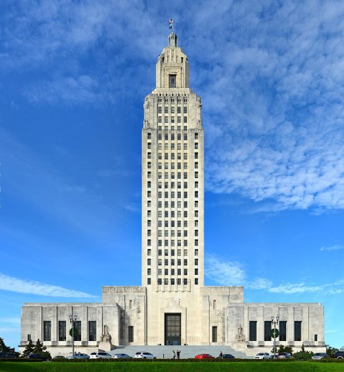
74 listings, 3 of them National Historic Landmarks: 58 buildings, among them the Old Louisiana State Capitol (a National Historic Landmark since 1974) and the Magnolia Mound Plantation House (listed 1972, the first), 12 historic districts with 1,965 contributing buildings, 3 sites, and 2 structures. 2,042 historic buildings in all.
How old are the homes in Baton Rouge?
6% of Baton Rouge’s homes were built before 1940 (Census estimate), against a typical 3.4% for a Louisiana town; the median home was built in 1976.
Founding dates: Wikidata, Wikipedia, the U.S. post office records of Blevins & Helbock (CC0) and the Census. Homes by year built: Census ACS 2020–24. National Register of Historic Places: National Park Service (list of May 22, 2026). Old photos, postcards and papers: Wikimedia Commons, the Library of Congress and other public archives, credited on each item’s page. Maps: U.S. Geological Survey historical topographic maps (via Esri) and Sanborn fire-insurance maps (Library of Congress). History text and census tables: Wikipedia (CC BY-SA 4.0). Places that used to be: USGS Geographic Names Information System (2021).
From Wikimedia Commons (10), the Library of Congress (12), Wikidata (1), the National Register of Historic Places (75), Wikipedia, Wikidata and Wikipedia for famous people, U.S. Geological Survey historical maps, U.S. Census counts (via Wikipedia), the US Post Offices dataset (Blevins & Helbock), the USGS Geographic Names Information System and Sanborn fire insurance maps (Library of Congress). Archive images are copied here with their credits and licenses, shown on each photo’s page. Refreshed monthly.


 ★ Landmark
 ★ Landmark
 ★ Landmark






 1862
 1862
 1863
 1880
 1880
 1880
 1887
 1891
 1907
 1909
 1910
 1910
 1911
 1919
 1920s
 1923


