The Yorktown post office opened in 1836, the earliest record of the town by name. Four smaller post offices, Reed's Station (1876), Cammack (1882) and Reed (1882), opened inside today’s town and later closed.
First census: 331 in 18802020 census: 11,548190 years
How historic is Yorktown?
B+
More historic than 70% of U.S. towns, on its age, its old homes and the National Register.
Founding year: the first Yorktown post office (Blevins & Helbock, CC0).The full story ↓
History grade
What drives Yorktown’s History grade
On its age, its old homes and the National Register, Yorktown is more historic than 70% of U.S. towns, #290 of 593 in Indiana. All 3 inputs are above most U.S. towns; its age ranks highest and its share of homes from before 1940 lowest.
B+
HistoryA character grade: shown, never part of Yorktown’s overall grade.
Indiana towns list more on the Register than most of the country (a typical Indiana town has 7.9 per 10,000 residents, the U.S. 2.4), so Yorktown’s 2.6 sits near the middle of its state (49% of Indiana towns have fewer) while its 3 historic buildings outnumber those of 65% of U.S. towns.
How sure. Graded on any two of the three inputs instead, the letter would range from B to B+. The pre-1940 share is a Census survey estimate (±4.0 points). The founding year is the first post office, not a stated founding date.
Founding year: the first post office (other dates in Quick answers). Homes: Census ACS 2020–24. National Register: National Park Service, May 2026 list; each listing counted once (boundary changes and added documentation belong to their listing), and a historic district counts its contributing buildings. How TownRatings grades history →
What stands out about Yorktown’s past
Read from the archive, the National Register and the record. The page puts what stands out first.
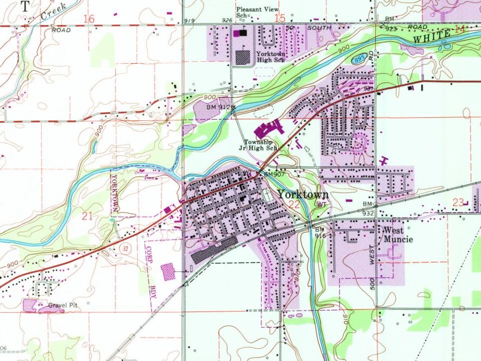
During the Woodland period Native Americans built an earthen enclosure just to the east of Yorktown, still visible on Google Earth at 40.1805°N 85.4694°W / 40.1805; -85.4694. Yorktown lies at the junction of the White River and Buck Creek. According to local legend, the Miami Indians believed that the peculiar configuration of the junction made Yorktown immune from tornadoes.
Yorktown was platted in 1837 by Oliver H. Smith who represented Indiana in the U.S. Senate from 1837 to 1843 and was a member of the Committee on Public Lands. Smith eventually became involved in the railroad business, and Yorktown was joined to Indianapolis by railroad in the early 1850s. Yorktown's main street bears Smith's name.
The Old English Tavern, now called the Yorktown Hotel, was the first tavern to be built in Yorktown. It was here that Washington, LaFayette, Cornwallis and other great generals were entertained. It is thought by some to be the oldest house now standing in Yorktown.
Text read by machine from the scan; it may contain errors.
The President’s Appeal to the Public.— A joint stock company known as the Yorktown Centennial Association has recently been incorporated and organized under the laws of the State of Virginia. The object of this company as set forth in its charter is to promote and secure the proper celebration in October, 1881, of the One Hundredth Anniversary of the Surrender of Yorktown, Virginia, of the British forces under Lord Cornwallis. By the act of Congress approved June 7, 1880, the sum of twenty thousand dollars was appropriated for the purpose of de-
Text read by machine from the scan; it may contain errors.
The monument which stands to-day in Yorktown was built to commemorate the victory of the Revolution. In 1781 the first Congress which met after the Revolutionary War adopted resolutions ordering one hundred thousand dollars to be appropriated to build a monument in Yorktown to commemorate the victor V of the Americans.
Text read by machine from the scan; it may contain errors.
A twentieth century history of Delaware County, Indiana1908 · page 94Read the page →
Read the text
in six directions. Too much emphasis cannot be placed on the part played by these early railroad lines in distributing population and starting towns and industries. The first railroad in 1852 found two towns in the county already established — Muncie and Yorktown — and it immediately put those towns, especially Muncic, on a new basis and started their development. Furthermore, the railroad was the cause of the founding of the town of Sclma, at the same time destroying Smithfield's prospects; and revived the village of Dalevillc, which had nearly lost its identity since the pioneer days. Twenty
Text read by machine from the scan; it may contain errors.
Scans and text from the Internet Archive. Books published in 1930 or earlier, which are in the public domain.
The Yorktown post office opened in 1836, the earliest record of the town by name (U.S. post office records).
How does Yorktown rank for history?
Yorktown is more historic than 70% of U.S. towns, #290 of 593 in Indiana. The History grade combines the town’s founding era, the share of homes built before 1940 and its National Register listings. It’s a character grade, so it isn’t part of the overall grade. How it works.
What is on the National Register in Yorktown?
One place: the Martin Hofherr Farm (listed 1992).
How old are the homes in Yorktown?
12% of Yorktown’s homes were built before 1940 (Census estimate, ±4.0 points), against a typical 14% for an Indiana town; the median home was built in 1972.
Founding dates: Wikidata, Wikipedia, the U.S. post office records of Blevins & Helbock (CC0) and the Census. Homes by year built: Census ACS 2020–24. National Register of Historic Places: National Park Service (list of May 22, 2026). Old photos, postcards and papers: Wikimedia Commons, the Library of Congress and other public archives, credited on each item’s page. Maps: U.S. Geological Survey historical topographic maps (via Esri) and Sanborn fire-insurance maps (Library of Congress). History text and census tables: Wikipedia (CC BY-SA 4.0). Places that used to be: USGS Geographic Names Information System (2021).
From Wikimedia Commons (5), the Library of Congress (2), the National Register of Historic Places (1), Wikipedia, Wikidata and Wikipedia for famous people, U.S. Geological Survey historical maps, U.S. Census counts (via Wikipedia), the US Post Offices dataset (Blevins & Helbock), the USGS Geographic Names Information System and old county and town histories (Internet Archive). Archive images are copied here with their credits and licenses, shown on each photo’s page. Refreshed monthly.


 Date?
 Date?
 Date?
 Date?
 2024
 2023
 2016