Princeton dates to 1814, and 29% of its homes were built before 1940
More historic than 94% of U.S. towns · #98 of 593 in Indiana. What drives it
4 places in town are on the National Register, among them two historic districts with 99 buildings between them. Below: 3 old photos and papers, maps from 1887 on, and the census since 1840.
Founding year: Wikidata. First post office: 1816.The full story ↓
History grade
What drives Princeton’s History grade
On its age, its old homes and the National Register, Princeton is more historic than 94% of U.S. towns, #98 of 593 in Indiana. All 3 inputs are above most U.S. towns; its National Register listings ranks highest and its age lowest.
A
HistoryA character grade: shown, never part of Princeton’s overall grade.
Indiana towns list more on the Register than most of the country (a typical Indiana town has 7.9 per 10,000 residents, the U.S. 2.4), so Princeton’s 121 sits above most of its state (83% of Indiana towns have fewer) while its 101 historic buildings outnumber those of 89% of U.S. towns.
How sure. Graded on any two of the three inputs instead, the letter would still be A. The pre-1940 share is a Census survey estimate (±5.1 points). Two sources give 1814.
Founding year: Wikidata (other dates in Quick answers). Homes: Census ACS 2020–24. National Register: National Park Service, May 2026 list; each listing counted once (boundary changes and added documentation belong to their listing), and a historic district counts its contributing buildings. How TownRatings grades history →
What stands out about Princeton’s past
Read from the archive, the National Register and the record. The page puts what stands out first.
National Park Service, National Register of Historic Places. Photos from Wikimedia Commons, credited on each place’s page.
Every building
Princeton, building by building, 1887–1914
Fire insurance maps drew every building, what it was made of and what it was used for, so insurers could price the risk of fire. Pick a year, then a sheet.
In 1800, the Indiana Territory was created with Vincennes (Knox County) as its capital. The rich farmlands in the southwest of the territory with access to the Ohio River attracted many pioneers and settlers to the area, one of whom was an Irish immigrant named William Prince. Born in 1772, he immigrated to America at the age of 22. He later became a Gibson County Commissioner and the county seat of Princeton is named after him.
Passages that mention Princeton, cut from the printed page as they were published.
History of Princeton and its institutions1879Read the page →
Read the text
paid by the treasurer. There are statements published that the removal did not take place till the year 1757, but Mr. Nathaniel Fitz Randolph, then a resident of Princeton, in his journal already quoted, entered that it was in " 1756, Aaron Burr, president, preached his first sermon and began the first school in Princeton college." There is no sufficient ground to doubt that the removal of the college, that is the president, officers and the students, about seventy in number, and the
Text read by machine from the scan; it may contain errors.
History of Princeton and its institutions1879Read the page →
Read the text
This is the colored Presbyterian church of Princeton, which was set off from the First church. As early as 1837, soon after the rebuilding of the First church after the fire of 1835, a committee of the trustees of that church was appointed to confer with its colored members in reference to their returning to the new church. Professor A. B. Dod and Mr. Lawrence were that committee. A month later the trustees resolved that one more attempt should be made to induce the colored people
Text read by machine from the scan; it may contain errors.
The history of Princeton, Worcester county, Mass. from its first settlement1838 · page 19Read the page →
Read the text
incorporation, inasmuch as it embraces all the lands adjoining said District," not previously incorporated with any town, or district, I am at a loss to ascertain. The inhabitants of Princeton seem to have been extremely reluctant that any extension of the original district lines should be made. In October, 1771, the following vote was passed : — " That it is the opinion of the town, that it is a hardship both to the towns and the farms lately laid to it, that they should be an-
Text read by machine from the scan; it may contain errors.
Scans and text from the Internet Archive. Books published in 1930 or earlier, which are in the public domain.
Timeline
Princeton, 1814 to 1997
Woven from the archive, old maps, post office records, the National Register and the people born here.
Nothing in the archives for these yearsWeddings on Main Street, storms, parades, school pictures, the old store. If it’s in your family album, it belongs here.
US Post Offices dataset (Blevins & Helbock, CC0). Places and cemeteries from the USGS Geographic Names Information System (2021).
Questions about Princeton’s history
What year was Princeton founded?
In 1814, according to Wikidata. Princeton’s post office opened in 1816, and the census of 1840 counted 573 people here.
How does Princeton rank for history?
Princeton is more historic than 94% of U.S. towns, #98 of 593 in Indiana. The History grade combines the town’s founding era, the share of homes built before 1940 and its National Register listings. It’s a character grade, so it isn’t part of the overall grade. How it works.
What is on the National Register in Princeton?
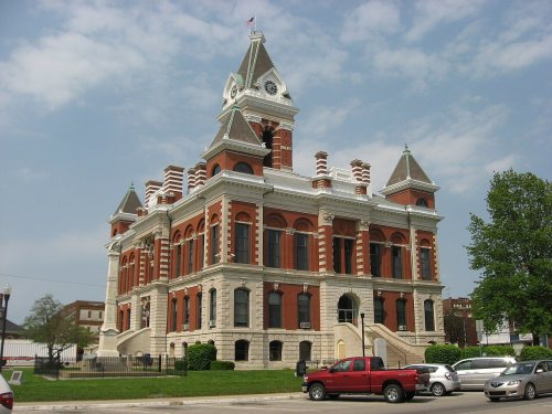
4 listings: 2 buildings, among them the Gibson County Courthouse (listed 1984, the first), and 2 historic districts, the Princeton Courthouse Square Historic District and the Princeton Westside Historic District, with 99 contributing buildings. 101 historic buildings in all.
How old are the homes in Princeton?
29% of Princeton’s homes were built before 1940 (Census estimate, ±5.1 points), against a typical 14% for an Indiana town; the median home was built in 1971.
Founding dates: Wikidata, Wikipedia, the U.S. post office records of Blevins & Helbock (CC0) and the Census. Homes by year built: Census ACS 2020–24. National Register of Historic Places: National Park Service (list of May 22, 2026). Old photos, postcards and papers: Wikimedia Commons, the Library of Congress and other public archives, credited on each item’s page. Maps: U.S. Geological Survey historical topographic maps (via Esri) and Sanborn fire-insurance maps (Library of Congress). History text and census tables: Wikipedia (CC BY-SA 4.0). Places that used to be: USGS Geographic Names Information System (2021).
From Wikimedia Commons (11), the Library of Congress (1), the National Register of Historic Places (4), Wikipedia, Wikidata and Wikipedia for famous people, U.S. Geological Survey historical maps, U.S. Census counts (via Wikipedia), the US Post Offices dataset (Blevins & Helbock), the USGS Geographic Names Information System, Sanborn fire insurance maps (Library of Congress) and old county and town histories (Internet Archive). Archive images are copied here with their credits and licenses, shown on each photo’s page. Refreshed monthly.





 1907
 2011
 2006
 2006
 2006
 2006
 2006
 2006
 2006
 2005


