Peru dates to 1834, and 49% of its homes were built before 1940
More historic than 98% of U.S. towns · #20 of 593 in Indiana. What drives it
8 places in town are on the National Register, among them four historic districts with 433 buildings between them. Below: 10 old photos and papers, maps from 1883 on, and the census since 1850.
Founding year: Wikidata; Wikipedia’s history section gives the same year. First post office: 1829.The full story ↓
History grade
What drives Peru’s History grade
On its age, its old homes and the National Register, Peru is more historic than 98% of U.S. towns, #20 of 593 in Indiana. All 3 inputs are above most U.S. towns; its share of homes from before 1940 ranks highest and its age lowest.
A+
HistoryA character grade: shown, never part of Peru’s overall grade.
Indiana towns list more on the Register than most of the country (a typical Indiana town has 7.9 per 10,000 residents, the U.S. 2.4), so Peru’s 402 sits above most of its state (94% of Indiana towns have fewer) while its 438 historic buildings outnumber those of 97% of U.S. towns.
How sure. Graded on any two of the three inputs instead, the letter would range from A to A+. The pre-1940 share is a Census survey estimate (±4.7 points). Two sources give 1834.
Founding year: Wikidata (other dates in Quick answers). Homes: Census ACS 2020–24. National Register: National Park Service, May 2026 list; each listing counted once (boundary changes and added documentation belong to their listing), and a historic district counts its contributing buildings. How TownRatings grades history →
What stands out about Peru’s past
Read from the archive, the National Register and the record. The page puts what stands out first.
National Park Service, National Register of Historic Places. Photos from Wikimedia Commons, credited on each place’s page.
Every building
Peru, building by building, 1883–1920
Fire insurance maps drew every building, what it was made of and what it was used for, so insurers could price the risk of fire. Pick a year, then a sheet.
On August 18, 1827, Joseph Holman bought land near the confluence of the Mississinewa and Wabash rivers from Jean Baptiste "Pechewa" (Wildcat) Drouet de Richardville, the chief of the Miami people. The sale was approved on March 3, 1828, by President John Quincy Adams. On March 12, 1829, Holman had the land surveyed and laid out the town of Miamisport.
Passages that mention Peru, cut from the printed page as they were published.
The history of Peru, in the county of Oxford and state of Maine, from 1789 to 1911. Residents and genealogies of their families, also a part of Franklin plan1912 · page 20Read the page →
Read the text
To Wm. Brackett, one of the freehold inhabitants of the town of Peru, in said county: In the name of the State of Maine you are hereby required to notify and warn the freeholders and other inhabitants of said town of Peru, qualified by law to vote in town affairs, to assemble at the
Text read by machine from the scan; it may contain errors.
History of Miami County, Indiana1914 · page 104Read the page →
Read the text
Besides the articles designated by the commissioners at the September term, the stone contained a directory of the city of Peru, a list of the officers and members of the Peru Commercial Club, a roster of the Miami county Medical Society, a list of the rural mail routes from the Peru postoffice, four five-dollar national bank bills from the First National Bank of Peru, a ten-dollar national bank bill issued by tlie Citizens National Bank of Peru, an envelope from the contractors contain-
Text read by machine from the scan; it may contain errors.
The history of Peru, in the county of Oxford and state of Maine, from 1789 to 1911. Residents and genealogies of their families, also a part of Franklin plan1912 · page 33Read the page →
Read the text
Peru Baptist Church Plantation Number One, from which, in 1821, was incorporated the town of Peru, was settled about the year 1800. Some Baptist families were among tlie early settlers. At the request of these resident Baptists a council was called September 9, 1818, at the house of Benjamin Wormell, for the purpose of cluircli organization. This council consisted of delegates from the Baptist church at Dixfield, and the First and Second Baptist churclies of
Text read by machine from the scan; it may contain errors.
History of Miami County, Indiana1914 · page 163Read the page →
Read the text
strances were referred to a committee of three — Higgins, Adkinson and Brown — which reported the following ordinance : "Be it ordained by the mayor and common couneil of the town of Peru, that the ordinance entitled 'An ordinance to restrain swine from running at large within the corporation of the town of Peru' and all ordinances amendatory thereto, as also all ordinances or parts of ordinances lending in any maimer to restrain swine from the enjoyment of the lai'gest liberty, be and the same are hereby repealed."
Text read by machine from the scan; it may contain errors.
Scans and text from the Internet Archive. Books published in 1930 or earlier, which are in the public domain.
Timeline
Peru, 1829 to 1974
Woven from the archive, old maps, post office records, the National Register and the people born here.
Nothing in the archives for these yearsWeddings on Main Street, storms, parades, school pictures, the old store. If it’s in your family album, it belongs here.
Nothing in the archives for these yearsWeddings on Main Street, storms, parades, school pictures, the old store. If it’s in your family album, it belongs here.
In 1834, according to Wikidata and Wikipedia’s history of the town. Peru’s post office opened in 1829, and the census of 1850 counted 1,266 people here.
How does Peru rank for history?
Peru is more historic than 98% of U.S. towns, #20 of 593 in Indiana. The History grade combines the town’s founding era, the share of homes built before 1940 and its National Register listings. It’s a character grade, so it isn’t part of the overall grade. How it works.
What is on the National Register in Peru?
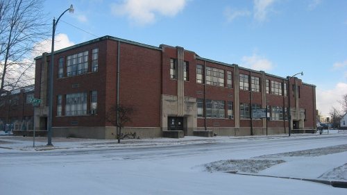
8 listings: 4 buildings, among them the Brownell Block/Senger Dry Goods Company Building (listed 1983, the first), and 4 historic districts with 433 contributing buildings. 438 historic buildings in all.
How old are the homes in Peru?
49% of Peru’s homes were built before 1940 (Census estimate, ±4.7 points), against a typical 14% for an Indiana town; the median home was built in 1942.
Founding dates: Wikidata, Wikipedia, the U.S. post office records of Blevins & Helbock (CC0) and the Census. Homes by year built: Census ACS 2020–24. National Register of Historic Places: National Park Service (list of May 22, 2026). Old photos, postcards and papers: Wikimedia Commons, the Library of Congress and other public archives, credited on each item’s page. Maps: U.S. Geological Survey historical topographic maps (via Esri) and Sanborn fire-insurance maps (Library of Congress). History text and census tables: Wikipedia (CC BY-SA 4.0). Places that used to be: USGS Geographic Names Information System (2021).
From Wikimedia Commons (20), the Library of Congress (4), the National Register of Historic Places (8), Wikipedia, Wikidata and Wikipedia for famous people, U.S. Geological Survey historical maps, U.S. Census counts (via Wikipedia), the US Post Offices dataset (Blevins & Helbock), the USGS Geographic Names Information System, Sanborn fire insurance maps (Library of Congress) and old county and town histories (Internet Archive). Archive images are copied here with their credits and licenses, shown on each photo’s page. Refreshed monthly.




 1879
 1908
 1908
 1908
 1908
 1908
 2013
 2013
 2013
 2013
 2013
 2013
 2011
 2011
 2011
 2011
 2010
 2007
 2005
 2005


