Metamora dates to 1836, and 2 of its places are on the National Register
More historic than 68% of U.S. towns · #275 of 768 in Illinois. What drives it
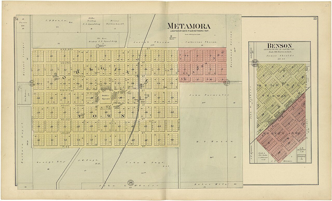
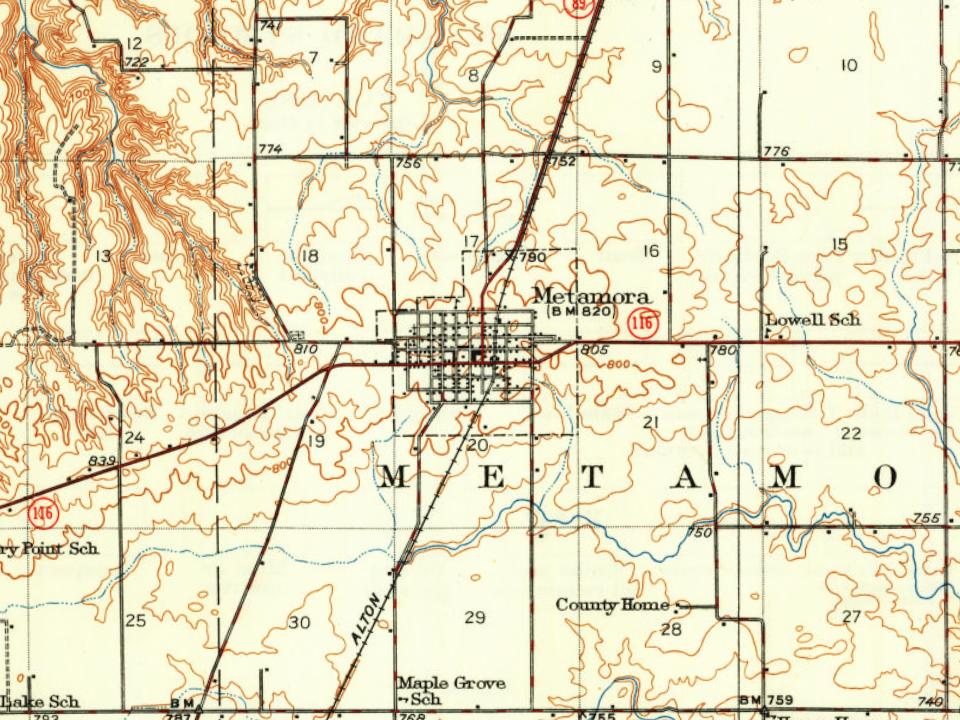
Most of Metamora was built recently: 7% of its homes predate 1940 and the median home dates from 1978. Its Register listings are the Metamora Courthouse and the Adlai E. Stevenson I House. Its Register listings are the Metamora Courthouse and the Adlai E. Stevenson I House. Below: 1 old photo or paper, maps from 1893 on, and the census since 1860.
On its age, its old homes and the National Register, Metamora is more historic than 68% of U.S. towns, #275 of 768 in Illinois. Its age holds the grade up; its share of homes from before 1940 pulls it down.
B+
HistoryA character grade: shown, never part of Metamora’s overall grade.
Few Illinois towns list much on the Register (a typical Illinois town has 0.5 per 10,000 residents, the U.S. 2.4), so Metamora’s 4.8 sits above most of its state (75% of Illinois towns have fewer) while its 2 listings outnumber those of 60% of U.S. towns.
How sure. Graded on any two of the three inputs instead, the letter would range from B to A−. The pre-1940 share is a Census survey estimate (±4.9 points). Two sources give 1836.
Founding year: Wikidata (other dates in Quick answers). Homes: Census ACS 2020–24. National Register: National Park Service, May 2026 list; each listing counted once (boundary changes and added documentation belong to their listing), and a historic district counts its contributing buildings. How TownRatings grades history →
What stands out about Metamora’s past
Read from the archive, the National Register and the record. The page puts what stands out first.
Metamora was settled by Yankee settlers. These were people from New England who were descended from the English Puritans who settled that region in the 1600s. The first group were settlers from Hanover, New Hampshire, organized by a company from Gilmanton, New Hampshire who named the town Hanover. A New England man named John Page scouted the area for the company and decided that this particular tract of land would be a good place for farms. When they arrived the area was a forest, with no roads and no structures. The New Hampshire settlers cleared the forest, constructed roads and built farms as well as a small town to support the farms. Other New England settlers arrived shortly thereafter from the states of Rhode Island, Vermont and Massachusetts. Metamora was the county seat of Woodford County from 1843 until 1896. The Metamora Courthouse State Historic Site, a courthouse from this…
Passages that mention Metamora, cut from the printed page as they were published.
The Past and present of Woodford County, Illinois1878 · page 283Read the page →
Read the text
Black Partridge Post Office, mentioned as the first in Woodford County, was the first in Metamora Township. It was kept by James Boys, at his own house, about three miles north of the present village of Metamora. It did not last very long, and, after its discontinuance, Rev. Wm. Davenport petitioned the Government for an office to be called Hanover. But there being another
Text read by machine from the scan; it may contain errors.
The Past and present of Woodford County, Illinois1878 · page 254Read the page →
Read the text
way of" salvation." The first churches organized in the county were the Baptist Church in the southeastern part of the county in 1837 ; the Christian Church at Eureka and the Episcopal Church at Metamora soon after. The Catholic Church of the Immaculate Conception, in the present township of Worth, was organized in 1838, and the Methodist Church of Metamora, and Mount Zion at the head of Walnut Grove, was organized at a very early day.
Text read by machine from the scan; it may contain errors.
Scans and text from the Internet Archive. Books published in 1930 or earlier, which are in the public domain.
By decade
Metamora, decade by decade
One decade in the archive so far: the 1890s. Scroll each row; tap a photo for its story.
Nothing in the archives for these yearsWeddings on Main Street, storms, parades, school pictures, the old store. If it’s in your family album, it belongs here.
In 1836, according to Wikidata. Metamora’s post office opened in 1845, and the census of 1860 counted 966 people here.
How does Metamora rank for history?
Metamora is more historic than 68% of U.S. towns, #275 of 768 in Illinois. The History grade combines the town’s founding era, the share of homes built before 1940 and its National Register listings. It’s a character grade, so it isn’t part of the overall grade. How it works.
What is on the National Register in Metamora?
Two places: the Metamora Courthouse (listed 1978) and the Adlai E. Stevenson I House (1980).
How old are the homes in Metamora?
7% of Metamora’s homes were built before 1940 (Census estimate, ±4.9 points), against a typical 11% for an Illinois town; the median home was built in 1978.
Founding dates: Wikidata, Wikipedia, the U.S. post office records of Blevins & Helbock (CC0) and the Census. Homes by year built: Census ACS 2020–24. National Register of Historic Places: National Park Service (list of May 22, 2026). Old photos, postcards and papers: Wikimedia Commons, the Library of Congress and other public archives, credited on each item’s page. Maps: U.S. Geological Survey historical topographic maps (via Esri) and Sanborn fire-insurance maps (Library of Congress). History text and census tables: Wikipedia (CC BY-SA 4.0). Places that used to be: USGS Geographic Names Information System (2021).
From Wikimedia Commons (6), the National Register of Historic Places (2), Wikipedia, Wikidata and Wikipedia for famous people, U.S. Geological Survey historical maps, U.S. Census counts (via Wikipedia), the US Post Offices dataset (Blevins & Helbock), the USGS Geographic Names Information System and old county and town histories (Internet Archive). Archive images are copied here with their credits and licenses, shown on each photo’s page. Refreshed monthly.





 2009
 2009
 2009
 2009
 2009

