Lemont dates to 1836, and 3 of its places are on the National Register
More historic than 79% of U.S. towns · #185 of 768 in Illinois. What drives it
Most of Lemont was built recently: 8% of its homes predate 1940 and the median home dates from 1995. 3 places in town are on the National Register, among them a historic district with 54 buildings. Below: 5 old photos and papers, maps from 1886 on, and the census since 1880.
Founding year: Wikidata. First post office: 1840.The full story ↓
History grade
What drives Lemont’s History grade
On its age, its old homes and the National Register, Lemont is more historic than 79% of U.S. towns, #185 of 768 in Illinois. Its National Register listings hold the grade up; its share of homes from before 1940 pulls it down.
A−
HistoryA character grade: shown, never part of Lemont’s overall grade.
Few Illinois towns list much on the Register (a typical Illinois town has 0.5 per 10,000 residents, the U.S. 2.4), so Lemont’s 31.4 sits above most of its state (89% of Illinois towns have fewer) while its 56 historic buildings outnumber those of 86% of U.S. towns.
How sure. Graded on any two of the three inputs instead, the letter would range from B to A. The pre-1940 share is a Census survey estimate (±3.5 points). Two sources give 1836.
Founding year: Wikidata (other dates in Quick answers). Homes: Census ACS 2020–24. National Register: National Park Service, May 2026 list; each listing counted once (boundary changes and added documentation belong to their listing), and a historic district counts its contributing buildings. How TownRatings grades history →
What stands out about Lemont’s past
Read from the archive, the National Register and the record. The page puts what stands out first.
Before European settlers arrived in Lemont, Native Americans traveled the Des Plaines River in birch bark canoes on trading trips between the Mississippi River and Lake Michigan. The native Potawatomi lived off the land in this area, directly using natural resources for food, shelter, clothing and medicine. In the 18th century, French voyageurs traveled down the Des Plaines River, trading Native Americans metal, beads and cloth for animal furs.
Passages that mention Lemont, cut from the printed page as they were published.
History of Cook County, Illinois. From the earliest period to the present time1884 · page 852Read the page →
Read the text
free-Will Baptist- Church. Mr. Cleveland has been Commissioner of Highways, and school trustee of the town of Lemont, WILLIAM R. DERBY, retired. Lemont. is probably the oldest settler now living in this township, having settled en Sections 34, 37 and 11, about three miles southeast of the present village of Lemont, in May, 1*34. There was at tlujl lime but one or two houses between Juliet und Chicago lie
Text read by machine from the scan; it may contain errors.
History of Cook County, Illinois. From the earliest period to the present time1884 · page 823Read the page →
Read the text
The first road laid out after the town organization was ordered on the application of Richard C leveland, of Lemont, and was surveyed and constructed as the joint undertaking of the two townships. Its course was as follows: " Beginning at the southeast corner of Lemont, and the southwest corner of Palos, and running thence north on or near the line between the aforesaid townships, to the center of the road leading from Des-
Text read by machine from the scan; it may contain errors.
History of Cook County, Illinois1909 · page 298Read the page →
Read the text
erected at a cost of $4,000. The German Lutheran society was organized in 1872, but continued to meet in the schoolhouse until 1874, when they secured their first church building. Among the early hotels in the village of Lemont was one built by Michael Kearney in 1861. The Township of Proviso originally contained thirty-six sections, being a full Congressional township. In 1870 the township of Riverside took from it four of the southwestern sections. The Des
Text read by machine from the scan; it may contain errors.
Scans and text from the Internet Archive. Books published in 1930 or earlier, which are in the public domain.
By decade
Lemont, decade by decade
3 decades in the archive, from the 1900s to the 1940s. Scroll each row; tap a photo for its story.
Nothing in the archives for these yearsWeddings on Main Street, storms, parades, school pictures, the old store. If it’s in your family album, it belongs here.
Every edition of the U.S. Geological Survey’s map of Lemont. Tap a year, or press play to watch the town change.
1954Romeoville sheet · 1:24,000
U.S. Geological Survey historical topographic maps (public domain), via Esri’s collection of the scans. The red ring marks the center of Lemont.
Every building
Lemont, building by building, 1886–1894
Fire insurance maps drew every building, what it was made of and what it was used for, so insurers could price the risk of fire. Pick a year, then a sheet.
In 1836, according to Wikidata. Lemont’s post office opened in 1840, and the census of 1880 counted 2,108 people here.
How does Lemont rank for history?
Lemont is more historic than 79% of U.S. towns, #185 of 768 in Illinois. The History grade combines the town’s founding era, the share of homes built before 1940 and its National Register listings. It’s a character grade, so it isn’t part of the overall grade. How it works.
What is on the National Register in Lemont?
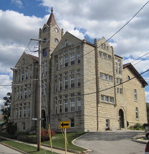
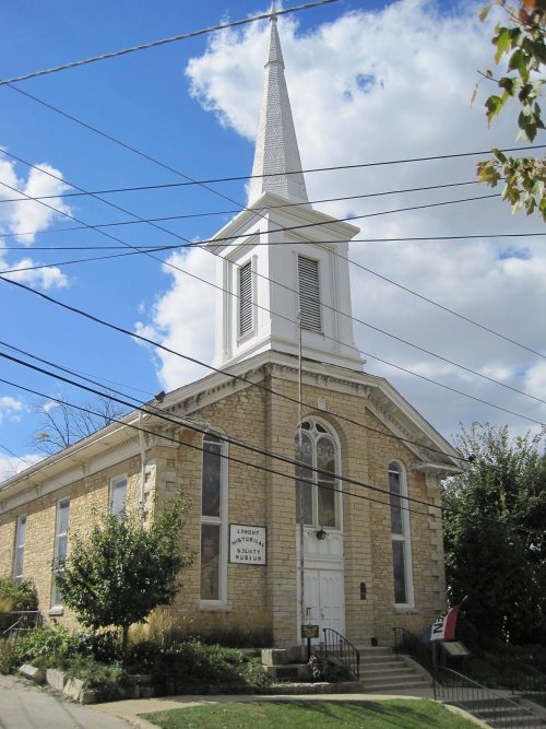
Three places: the Lemont Central Grade School (listed 1975), the Lemont Methodist Episcopal Church (1986) and the Lemont Downtown Historic District (2016).
How old are the homes in Lemont?
8% of Lemont’s homes were built before 1940 (Census estimate, ±3.5 points), against a typical 11% for an Illinois town; the median home was built in 1995.
Founding dates: Wikidata, Wikipedia, the U.S. post office records of Blevins & Helbock (CC0) and the Census. Homes by year built: Census ACS 2020–24. National Register of Historic Places: National Park Service (list of May 22, 2026). Old photos, postcards and papers: Wikimedia Commons, the Library of Congress and other public archives, credited on each item’s page. Maps: U.S. Geological Survey historical topographic maps (via Esri) and Sanborn fire-insurance maps (Library of Congress). History text and census tables: Wikipedia (CC BY-SA 4.0). Places that used to be: USGS Geographic Names Information System (2021).
From Wikimedia Commons (7), the Library of Congress (4), Wikidata (1), the National Register of Historic Places (3), Wikipedia, Wikidata and Wikipedia for famous people, U.S. Geological Survey historical maps, U.S. Census counts (via Wikipedia), the US Post Offices dataset (Blevins & Helbock), the USGS Geographic Names Information System, Sanborn fire insurance maps (Library of Congress) and old county and town histories (Internet Archive). Archive images are copied here with their credits and licenses, shown on each photo’s page. Refreshed monthly.


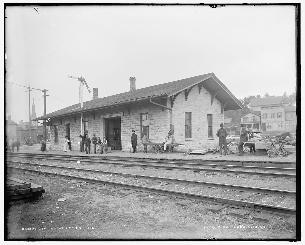




 1900
 1900
 2016
 2016
 2016
 2016
 2014
 2013


