Joliet Township dates to 1833, and 29% of its homes were built before 1940
More historic than 96% of U.S. towns · #27 of 768 in Illinois. What drives it
15 places in town are on the National Register, among them a historic district with 1 buildings. Below: 16 old photos and papers, maps from 1892 on, and the census since 1840.
Founding year: Wikidata. First post office: 1833.The full story ↓
History grade
What drives Joliet Township’s History grade
On its age, its old homes and the National Register, Joliet Township is more historic than 96% of U.S. towns, #27 of 768 in Illinois. All 3 inputs are above most U.S. towns; its National Register listings ranks highest and its age lowest.
A+
HistoryA character grade: shown, never part of Joliet Township’s overall grade.
Few Illinois towns list much on the Register (a typical Illinois town has 0.5 per 10,000 residents, the U.S. 2.4), so Joliet Township’s 113 sits above most of its state (94% of Illinois towns have fewer) while its 960 historic buildings outnumber those of 99% of U.S. towns.
How sure. Graded on any two of the three inputs instead, the letter would range from A to A+. The pre-1940 share (±1.8 points) is firm at this size. Two sources give 1833.
Founding year: Wikidata (other dates in Quick answers). Homes: Census ACS 2020–24. National Register: National Park Service, May 2026 list; each listing counted once (boundary changes and added documentation belong to their listing), and a historic district counts its contributing buildings. How TownRatings grades history →
What stands out about Joliet Township’s past
Read from the archive, the National Register and the record. The page puts what stands out first.
Every edition of the U.S. Geological Survey’s map of Joliet Township. Tap a year, or press play to watch the town change.
1892Joliet sheet · 1:62,500
U.S. Geological Survey historical topographic maps (public domain), via Esri’s collection of the scans. The red ring marks the center of Joliet Township.
On the National Register
15 listings protect 960 historic buildings
The country’s official list of buildings and places worth saving.
In 1673, Louis Jolliet, along with Father Jacques Marquette, paddled up the Des Plaines River and camped on a huge earthwork mound, a few miles south of present-day Joliet. Maps from Jolliet's exploration of the area showed a large hill or mound down river from Chicago, labeled Mont Joliet. The mound has since been flattened due to mining.
Passages that mention Joliet Township, cut from the printed page as they were published.
The history of Will County, Illinois, containing a history of the county ... a directory of its real estate owners1878 · page 371Read the page →
Read the text
Reason Zarley, to whom is generally attributed the honor of making the first permanent settlement in Joliet Township, came to Illinois in 1829, from Ohio, and to this neighborhood in the Spring of 1831, where he made a permanent settlement. He was a soldier in the last struggle of the United States with Johnny Bull, and was one of the few survivors of the bloody affair of Brownstown, where 100 American soldiers were attacked by 800 savages and 400 English, but little less savage than their red allies, and from which few of the former escaped to tell the tale of carnage. He was in the army, also, at the time of Hull's disgrace-
Text read by machine from the scan; it may contain errors.
History of Will County, Illinois1928 · page 613Read the page →
Read the text
The early life of Oscar Robert Laraway was spent in Joliet and on a farm in Joliet Township, five miles southeast of Joliet. He obtained his education in Rose Hill country school, Joliet Township High School, and in June, 1911, he received his degree from the College of Law, University of Michigan. He was admitted to the bar in the State of Illinois in October, 1911, and engaged in private practice until 1914. He was then associated in partnership with Judge Benjamin Olin until 1920, at which time Judge Olin died. Since that date Mr. Laraway
Text read by machine from the scan; it may contain errors.
History of Will County, Illinois1928 · page 668Read the page →
Read the text
Ernest Freeman attended the public schools of Joliet and for three years was a student at Joliet Township High School. When his school days were ended he found a place ready for him in his father's business which was founded in 1899. He has never been in any other business.
Text read by machine from the scan; it may contain errors.
Scans and text from the Internet Archive. Books published in 1930 or earlier, which are in the public domain.
Timeline
Joliet Township, 1833 to 1900
Woven from the archive, old maps, post office records, the National Register and the people born here.
Nothing in the archives for these yearsWeddings on Main Street, storms, parades, school pictures, the old store. If it’s in your family album, it belongs here.
In 1833, according to Wikidata. Joliet Township’s post office opened in 1833, and the census of 1840 counted 2,558 people here.
How does Joliet Township rank for history?
Joliet Township is more historic than 96% of U.S. towns, #27 of 768 in Illinois. The History grade combines the town’s founding era, the share of homes built before 1940 and its National Register listings. It’s a character grade, so it isn’t part of the overall grade. How it works.
What is on the National Register in Joliet Township?
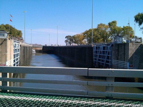
15 listings: 1 historic district, the Brandon Road Lock and Dam Historic District, with 1 contributing buildings. 960 historic buildings in all.
How old are the homes in Joliet Township?
29% of Joliet Township’s homes were built before 1940 (Census estimate, ±1.8 points), against a typical 11% for an Illinois town; the median home was built in 1957.
Founding dates: Wikidata, Wikipedia, the U.S. post office records of Blevins & Helbock (CC0) and the Census. Homes by year built: Census ACS 2020–24. National Register of Historic Places: National Park Service (list of May 22, 2026). Old photos, postcards and papers: Wikimedia Commons, the Library of Congress and other public archives, credited on each item’s page. Maps: U.S. Geological Survey historical topographic maps (via Esri) and Sanborn fire-insurance maps (Library of Congress). History text and census tables: Wikipedia (CC BY-SA 4.0). Places that used to be: USGS Geographic Names Information System (2021).
From Wikimedia Commons (5), the Library of Congress (11), Wikidata (2), the National Register of Historic Places (1), Wikipedia, U.S. Geological Survey historical maps, U.S. Census counts (via Wikipedia), the USGS Geographic Names Information System and old county and town histories (Internet Archive). Archive images are copied here with their credits and licenses, shown on each photo’s page. Refreshed monthly.




 1865
 1868
 1880
 1880
 1880
 1890
 1900
 1900
 1901
 1905
 1908
 1908