Greenville dates to 1815, and 18% of its homes were built before 1940
More historic than 76% of U.S. towns · #211 of 768 in Illinois. What drives it
Its Register listings are the Old Main, Almira College and the Greenville Public Library. Below: 2 old photos and papers, maps from 1886 on, and the census since 1880.
Founding year: Wikipedia. First post office: 1821.The full story ↓
History grade
What drives Greenville’s History grade
On its age, its old homes and the National Register, Greenville is more historic than 76% of U.S. towns, #211 of 768 in Illinois. All 2 inputs are above most U.S. towns; its share of homes from before 1940 ranks highest and its National Register listings lowest.
A−
HistoryA character grade: shown, never part of Greenville’s overall grade.
Few Illinois towns list much on the Register (a typical Illinois town has 0.5 per 10,000 residents, the U.S. 2.4), so Greenville’s 2.8 sits above most of its state (69% of Illinois towns have fewer) while its 2 listings outnumber those of 60% of U.S. towns.
How sure. Graded on two of the three inputs, so a change in either one moves the letter more than it would with three. The pre-1940 share is a Census survey estimate (±6.7 points). Two sources give 1815.
Founding year: Wikipedia (other dates in Quick answers). Homes: Census ACS 2020–24. National Register: National Park Service, May 2026 list; each listing counted once (boundary changes and added documentation belong to their listing), and a historic district counts its contributing buildings. How TownRatings grades history →
What stands out about Greenville’s past
Read from the archive, the National Register and the record. The page puts what stands out first.
Fire insurance maps drew every building, what it was made of and what it was used for, so insurers could price the risk of fire. Pick a year, then a sheet.
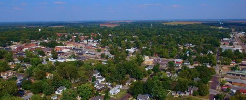
Greenville was founded by George Davidson in 1815 in what was then the Illinois Territory, when he purchased 160 acres (65 ha) along the bluff overlooking Little Shoal Creek, in what was then still part of Madison County. Davidson built a tavern near the present-day intersection of Main and Sixth streets, and by 1816 he was selling individual lots. The federal government established its first federal post office in Greenville in 1819. It was incorporated as a town in 1855 and as a city in 1872. At one time, it had neighborhoods called New Jerusalem, Piety Hill, Cobtown, and Buzzard Roost. A few possible reasons have been put forth for the naming of the town. Some think the town was named after Greenville, North Carolina, which had been named after Revolutionary War general Nathanael Greene. Others say that Greenville was named by early settler Thomas White because it was "so green and n…
Passages that mention Greenville, cut from the printed page as they were published.
Historical souvenir of Greenville, Illinois1905 · page 81Read the page →
Read the text
Mrs. S. M. Thomas, roads, and in turn the Vandalia Line has been one of the principal makers of Greenville. The early settlers of Greenville had an eye single to the good of the town, for we read, in our early history, that the people of Greenville, in mass
Text read by machine from the scan; it may contain errors.
Historical souvenir of Greenville, Illinois1905 · page 82Read the page →
Read the text
Greenville and Bond county men led in the enterprise of building the road and were for many years the officers of the road. On Tuesday, January 17, 1867, the vote in Bond county to determine whether or not the county would take stock in the railroad resulted 1,018 for and 143
Text read by machine from the scan; it may contain errors.
Scans and text from the Internet Archive. Books published in 1930 or earlier, which are in the public domain.
By decade
Greenville, decade by decade
One decade in the archive so far: the 1900s. Scroll each row; tap a photo for its story.
Nothing in the archives for these yearsWeddings on Main Street, storms, parades, school pictures, the old store. If it’s in your family album, it belongs here.
Greenville’s post office has been open since 1821.
Hamlets and corners on the map
Pauls Friendly City Mobile Home Park
Gone or out of use
First Christian ChurchchurchFirst Methodist ChurchchurchFirst Southern Baptist ChurchchurchGreenville Central Public SchoolschoolInglis Public SchoolschoolMcCord SchoolschoolPentecostal Assembly of God ChurchchurchTrue Vine Baptist Churchchurch
2cemeteries and burying grounds inside Greenville
LansingMontrose
US Post Offices dataset (Blevins & Helbock, CC0). Places and cemeteries from the USGS Geographic Names Information System (2021).
Stories next door
History across the town line
Each neighbor’s History grade, on the same three inputs.
In 1815, according to Wikipedia’s history of the town. Greenville’s post office opened in 1821, and the census of 1880 counted 1,886 people here.
How does Greenville rank for history?
Greenville is more historic than 76% of U.S. towns, #211 of 768 in Illinois. The History grade combines the town’s founding era, the share of homes built before 1940 and its National Register listings. It’s a character grade, so it isn’t part of the overall grade. How it works.
What is on the National Register in Greenville?
Two places: the Old Main, Almira College (listed 1975) and the Greenville Public Library (1995).
How old are the homes in Greenville?
18% of Greenville’s homes were built before 1940 (Census estimate, ±6.7 points), against a typical 11% for an Illinois town; the median home was built in 1973.
Founding dates: Wikidata, Wikipedia, the U.S. post office records of Blevins & Helbock (CC0) and the Census. Homes by year built: Census ACS 2020–24. National Register of Historic Places: National Park Service (list of May 22, 2026). Old photos, postcards and papers: Wikimedia Commons, the Library of Congress and other public archives, credited on each item’s page. Maps: U.S. Geological Survey historical topographic maps (via Esri) and Sanborn fire-insurance maps (Library of Congress). History text and census tables: Wikipedia (CC BY-SA 4.0). Places that used to be: USGS Geographic Names Information System (2021).
From Wikimedia Commons (8), the National Register of Historic Places (2), Wikipedia, Wikidata and Wikipedia for famous people, U.S. Geological Survey historical maps, U.S. Census counts (via Wikipedia), the US Post Offices dataset (Blevins & Helbock), the USGS Geographic Names Information System, Sanborn fire insurance maps (Library of Congress) and old county and town histories (Internet Archive). Archive images are copied here with their credits and licenses, shown on each photo’s page. Refreshed monthly.


 Date?
 2018
 2017
 2013
 2013
 2013
 2008


