More historic than 20% of U.S. towns · #635 of 768 in Illinois. What drives it
Most of Frankfort was built recently: 4% of its homes predate 1940 and the median home dates from 1999. Below: 6 old photos and papers, maps from 1930 on, and the census since 1880.
Founding year: Wikidata. First post office: 1838.The full story ↓
History grade
What drives Frankfort’s History grade
On its age, its old homes and the National Register, Frankfort is more historic than 20% of U.S. towns, #635 of 768 in Illinois. Its age holds the grade up; its share of homes from before 1940 pulls it down.
C−
HistoryA character grade: shown, never part of Frankfort’s overall grade.
Few Illinois towns list much on the Register (a typical Illinois town has 0.5 per 10,000 residents, the U.S. 2.4), so Frankfort’s 0.0 sits below most of its state (28% of Illinois towns have fewer) while its 0 listings outnumber those of 23% of U.S. towns.
NoteThe founding year comes from Wikidata alone; no second source gives 1879.
How sure. Graded on any two of the three inputs instead, the letter would still be C−. The pre-1940 share (±1.5 points) is firm at this size.
Founding year: Wikidata (other dates in Quick answers). Homes: Census ACS 2020–24. National Register: National Park Service, May 2026 list; each listing counted once (boundary changes and added documentation belong to their listing), and a historic district counts its contributing buildings. How TownRatings grades history →
What stands out about Frankfort’s past
Read from the archive, the National Register and the record. The page puts what stands out first.
First inhabited by Native Americans, including the Potawatomi and Sac and Fox tribes, Frankfort was used as a conduit between the Des Plaines and St. Joseph rivers. The area was part of the Virginia Territory until the French signed a treaty with Manitoqua, the Potawatomi chief, for land in the Prestwick area. The first pioneers came to Frankfort in the early 1830s by means of the Des Plaines River from the southwest and by wagon from the east along the Sauk Trail, a roadway that still exists.
Passages that mention Frankfort, cut from the printed page as they were published.
The history of Will County, Illinois, containing a history of the county ... a directory of its real estate owners1878 · page 514Read the page →
Read the text
The village of Frankfort was named for the township, and the township was named for Frankfort-on-the Main, as already noticed. Frankfort village is situated on the Joliet cut-ofi' of the Michigan Central Railroad, about twelve miles from Joliet, and was laid out in 1855 — the same year the cut-off railroad was built through the township. It was laid out by S. W. Bowen, who owned eighty acres of land embraced in the village. The first store was kept by a man named Higley, a very small affair (the store — not Higley), and did not continue long. The next store — and the first really deserving the name — was
Text read by machine from the scan; it may contain errors.
The history of Will County, Illinois, containing a history of the county ..1878 · page 514Read the page →
Read the text
The village of Frankfort was named for the township, and the township was named for Frankfort-on-the Main, as already noticed. Frankfort village is situated on the Joliet cut-off of the Michigan Central Railroad, about twelve miles from Joliet, and was laid out in 1855 — the same year the cut-off railroad was built through the township. It was laid out by S. W. Bowen, who owned eighty acres of land embraced in the village. The first store was kept by a man named Higley, a very small affair (the store — not Higley), and did not continue long. The next store — and the first really deserving the name — was
Text read by machine from the scan; it may contain errors.
The history of Will County, Illinois, containing a history of the county ... a directory of its real estate owners1878 · page 511Read the page →
Read the text
Lenox Township, but at that day was included in this settlement, or this was included in that, and all known as the Hickory Creek Settlement. Mr. Doty's residence was a regular preaching-place until the era of schoolhouses, as there was no church edifice built until after the village of Frankfort was laid out. There is but one church-building in the town outside of the villages — the German Lutheran Church — which is located about three miles northeast of Frankfort village. It was built in 1877 ; is a neat frame building, costing about |1,500, and has quite a flourishing membership. The church history will be again
Text read by machine from the scan; it may contain errors.
History of Will County, Illinois1928 · page 736Read the page →
Read the text
Robert E. Stephen was educated in the public schools of Frankfort, and learned telegraphy in the office of the Michigan Central Railroad at Frankfort. In 1896 he was appointed agent at Spencer for this railroad, and in 1900 was transferred to Dyer, Ind., as agent for the company. He was later sent to Chicago Heights, and then back to Dyer, Ind., and in August, 1906, was transferred to Frankfort, 111., as agent. In 1912 Mr. Stephen resigned from the railroad and in partnership with William Koerner purchased a general merchandise business.
Text read by machine from the scan; it may contain errors.
Scans and text from the Internet Archive. Books published in 1930 or earlier, which are in the public domain.
Timeline
Frankfort, 1838 to 2020
Woven from the archive, old maps, post office records, the National Register and the people born here.
Nothing in the archives for these yearsWeddings on Main Street, storms, parades, school pictures, the old store. If it’s in your family album, it belongs here.
In 1879, according to Wikidata. Frankfort’s post office opened in 1838, and the census of 1880 counted 332 people here.
How does Frankfort rank for history?
Frankfort is more historic than 20% of U.S. towns, #635 of 768 in Illinois. The History grade combines the town’s founding era, the share of homes built before 1940 and its National Register listings. It’s a character grade, so it isn’t part of the overall grade. How it works.
How old are the homes in Frankfort?
4% of Frankfort’s homes were built before 1940 (Census estimate, ±1.5 points), against a typical 11% for an Illinois town; the median home was built in 1999.
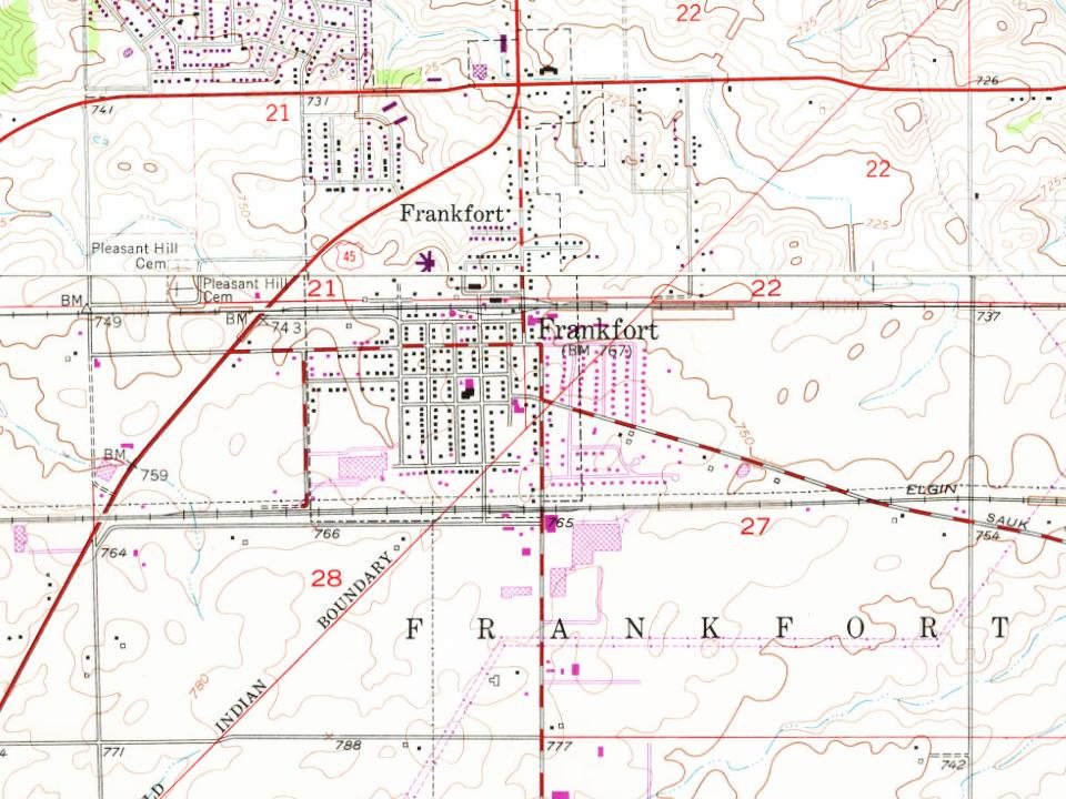
Founding dates: Wikidata, Wikipedia, the U.S. post office records of Blevins & Helbock (CC0) and the Census. Homes by year built: Census ACS 2020–24. National Register of Historic Places: National Park Service (list of May 22, 2026). Old photos, postcards and papers: Wikimedia Commons, the Library of Congress and other public archives, credited on each item’s page. Maps: U.S. Geological Survey historical topographic maps (via Esri) and Sanborn fire-insurance maps (Library of Congress). History text and census tables: Wikipedia (CC BY-SA 4.0). Places that used to be: USGS Geographic Names Information System (2021).
From Wikimedia Commons (6), Wikipedia, Wikidata and Wikipedia for famous people, U.S. Geological Survey historical maps, U.S. Census counts (via Wikipedia), the US Post Offices dataset (Blevins & Helbock), the USGS Geographic Names Information System and old county and town histories (Internet Archive). Archive images are copied here with their credits and licenses, shown on each photo’s page. Refreshed monthly.





 1933
 1933
 1933
 1933
 1933