Cicero was first counted by the census in 1860, and 62% of its homes were built before 1940
More historic than 73% of U.S. towns · #236 of 768 in Illinois. What drives it
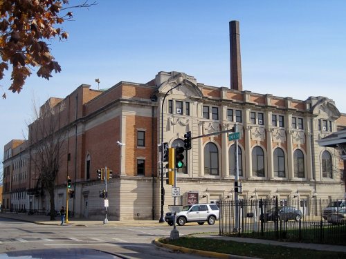
Its Register listing is the Morton, J. Sterling, High School East Auditorium. Its Register listing is the Morton, J. Sterling, High School East Auditorium. Below: 12 old photos and papers, maps from 1891 on, and the census since 1860.
Cicero first appears in the census in 1860. Three smaller post offices, Clyde (1873), Drexel (1894) and Hawthorne (1900), opened inside today’s town and later closed.
First census: 1,272 in 18602020 census: 85,268166 years
How historic is Cicero?
B+
More historic than 73% of U.S. towns, on its age, its old homes and the National Register.
On its age, its old homes and the National Register, Cicero is more historic than 73% of U.S. towns, #236 of 768 in Illinois. Its share of homes from before 1940 holds the grade up; its age pulls it down.
B+
HistoryA character grade: shown, never part of Cicero’s overall grade.
Few Illinois towns list much on the Register (a typical Illinois town has 0.5 per 10,000 residents, the U.S. 2.4), so Cicero’s 0.1 sits near the middle of its state (57% of Illinois towns have fewer) while its 1 listings outnumber those of 51% of U.S. towns.
How sure. Graded on any two of the three inputs instead, the letter would range from C+ to A. The pre-1940 share (±2.9 points) is firm at this size.
Founding year: the first census (other dates in Quick answers). Homes: Census ACS 2020–24. National Register: National Park Service, May 2026 list; each listing counted once (boundary changes and added documentation belong to their listing), and a historic district counts its contributing buildings. How TownRatings grades history →
What stands out about Cicero’s past
Read from the archive, the National Register and the record. The page puts what stands out first.
Originally, Cicero Township occupied an area six times the size of its current territory. The cities of Oak Park and Berwyn were incorporated from portions of Cicero Township, and other portions, such as Austin, were annexed into the city of Chicago.
Secession of Oak Park and Berwyn — On November 5, 1901, an election was held in the Town of Cicero for the purpose of permitting Oak Park and Berwyn to separate from the Town of Cicero and form independent villages. Accordingly all that territory lying between Austin Avenue (60th), North Avenue, Harlem Avenue (72nd), and Twelfth Street, became the Village, of Oak Park. This comprised the western half of Sections 5, 8^ and 17, and Sections 6, 7, and 18. The territory lying between
Text read by machine from the scan; it may contain errors.
McCafTery, living in the southeast portion of the district — a vilage called Brighton. He brought pressure to bear on the State Legislature, which on February 28, 1867, passed an act to incorporate the Town of Cicero. Thus it was changed from a governmental town to an incorporated town with a special charter Almost immediately amendments were agitated and the charter gas revised by act of the State Legislature on March 25, 1869.
Text read by machine from the scan; it may contain errors.
History of Cook County, Illinois. From the earliest period to the present time1884 · page 787Read the page →
Read the text
Chicago, in Kansas and Colorado. He founded tne village of Aus tin, which was named for him, 1866 He was interested in establishing o'her suburban towns, and also largely in the town of Cicero, within the limitsof which were located his investments. He was elected to the State Legislature in 1870, and Introduced the bill known as the West Side Park Hill, the passage oi which was mainly accredited to his efforts. He a »o prepared and introduced :he temperance bill March 31. 187 1, which received the (i ivenim's
Text read by machine from the scan; it may contain errors.
History of Cook County, Illinois. From the earliest period to the present time1884 · page 773Read the page →
Read the text
extending westward in the city of Chicago are laid out to the western limits of the town, thus subdividing the township in regular squares, Cicero has a municipal form of government, with its offices located at the village of Austin, one set of officers governing ali the suburban villages within its limits, as well as the general affairs of the town. The town of Cicero was first organized June 23. 1S57. when
Text read by machine from the scan; it may contain errors.
Scans and text from the Internet Archive. Books published in 1930 or earlier, which are in the public domain.
Timeline
Cicero, 1867 to 1943
Woven from the archive, old maps, post office records, the National Register and the people born here.
Nothing in the archives for these yearsWeddings on Main Street, storms, parades, school pictures, the old store. If it’s in your family album, it belongs here.
Nothing in the archives for these yearsWeddings on Main Street, storms, parades, school pictures, the old store. If it’s in your family album, it belongs here.
The Cicero post office opened in 1860, the earliest record of the town by name (U.S. post office records). Wikidata gives 1867.
How does Cicero rank for history?
Cicero is more historic than 73% of U.S. towns, #236 of 768 in Illinois. The History grade combines the town’s founding era, the share of homes built before 1940 and its National Register listings. It’s a character grade, so it isn’t part of the overall grade. How it works.
What is on the National Register in Cicero?
One place: the Morton, J. Sterling, High School East Auditorium (listed 1983).
How old are the homes in Cicero?
62% of Cicero’s homes were built before 1940 (Census estimate, ±2.9 points), against a typical 11% for an Illinois town; the median home was built in 1938.
Founding dates: Wikidata, Wikipedia, the U.S. post office records of Blevins & Helbock (CC0) and the Census. Homes by year built: Census ACS 2020–24. National Register of Historic Places: National Park Service (list of May 22, 2026). Old photos, postcards and papers: Wikimedia Commons, the Library of Congress and other public archives, credited on each item’s page. Maps: U.S. Geological Survey historical topographic maps (via Esri) and Sanborn fire-insurance maps (Library of Congress). History text and census tables: Wikipedia (CC BY-SA 4.0). Places that used to be: USGS Geographic Names Information System (2021).
From Wikimedia Commons (3), the Library of Congress (9), the National Register of Historic Places (1), Wikipedia, Wikidata and Wikipedia for famous people, U.S. Geological Survey historical maps, U.S. Census counts (via Wikipedia), the US Post Offices dataset (Blevins & Helbock), the USGS Geographic Names Information System and old county and town histories (Internet Archive). Archive images are copied here with their credits and licenses, shown on each photo’s page. Refreshed monthly.


 1943
 1943
 1943
 1943
 1943
 1943
 1943
 1943