Lost two-thirds of its people between 1890 and 1930, then grew 3-fold.
15 censuses, 1880–2020.
U.S. Census Bureau decennial counts, from the census table on Braceville’s Wikipedia page.
Every building
Braceville, building by building, 1885–1907
Fire insurance maps drew every building, what it was made of and what it was used for, so insurers could price the risk of fire. Pick a year, then a sheet.
1885Sheet 1 of 1
Edition
Sheets
BrickWoodStone
Sanborn Map Company, via the Library of Congress. Editions published in 1930 or earlier, which are in the public domain.
Timeline
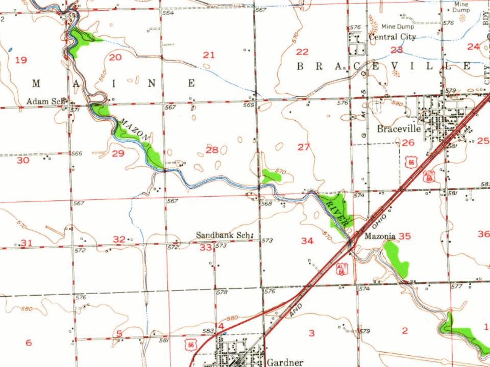
Braceville, 1834 to 1968
Woven from the archive, old maps, post office records, the National Register and the people born here.
Braceville was founded under the name "Sulphur Springs" by Reverend L. S. Robbins in 1834. In 1848, after Robbin's death, the town elected its first official supervisor, B. R. Dowd, who changed the name to Braceville after his home town of Braceville Township, Ohio. When coal was discovered in the region, residents became interested in the mining industry. However, no mines have ever been opened, and gradually, the town shifted its focus on other industries. The population has fluctuated over time, but is now growing at a steady rate.
Passages that mention Braceville, cut from the printed page as they were published.
History of Grundy County, Illinois1882 · page 118Read the page →
Read the text
afterward exchanged. On his return from the war, he was with his father for two years, and then built bridges with Alex Bruce, of Marseilles, for four years. Came to Braceville in 1871, and kept books for the Braceville Coal Company ; thence to Henry, Marshall County, engaging with Nicholson & Bruce for three and one-half years ; from there to Florida for two
Text read by machine from the scan; it may contain errors.
History of Grundy County, Illinois1882 · page 118Read the page →
Read the text
afterward exchanged. On his return from the war, he was with his father for two years, and then built bridges with Alex Bruce, of Jlarseilles, for four years. Came to Braceville in 1871, and kept books for the Braceville Coal Company ; theuce to Henry, Marshall County, engaging with Nicholson & Bruce for three and one-half 3-ears ; from there to Florida for two
Text read by machine from the scan; it may contain errors.
Historical encyclopedia of Illinois /cedited by Newton Bateman, Paul Selby,1914Read the page →
Read the text
BRACEVILLE The Village of Braceville was laid out by X. Cotton in 1SG1. Those residing in it were at one time largely interested in the coal industry, but in later years they have turned their attention to developing of enterprises in other directions. Some of the business and professional men of Braceville are: Peoples Bank of
Text read by machine from the scan; it may contain errors.
History of Grundy County, Illinois1882 · page 105Read the page →
Read the text
he closed out his business there and applied his time in Grundy County, erecting the first house in what is now the present site of the village of Braceville. The old building is now known as the Milwaukee Hotel. He used this building as a warehouse and for store room ; he bought corn at that time for 9 cents per bushel, and eggs at 3 cents per dozen. In
Text read by machine from the scan; it may contain errors.
Scans and text from the Internet Archive. Books published in 1930 or earlier, which are in the public domain.
By decade
Braceville, decade by decade
One decade in the archive so far: the 1960s. Scroll each row; tap a photo for its story.
Nothing in the archives for these yearsWeddings on Main Street, storms, parades, school pictures, the old store. If it’s in your family album, it belongs here.
Founding dates: Wikidata, Wikipedia, the U.S. post office records of Blevins & Helbock (CC0) and the Census. Homes by year built: Census ACS 2020–24. National Register of Historic Places: National Park Service (list of May 22, 2026). Old photos, postcards and papers: Wikimedia Commons, the Library of Congress and other public archives, credited on each item’s page. Maps: U.S. Geological Survey historical topographic maps (via Esri) and Sanborn fire-insurance maps (Library of Congress). History text and census tables: Wikipedia (CC BY-SA 4.0). Places that used to be: USGS Geographic Names Information System (2021). How TownRatings grades history →
From Wikimedia Commons (6), Wikipedia, Wikidata and Wikipedia for famous people, U.S. Geological Survey historical maps, U.S. Census counts (via Wikipedia), the US Post Offices dataset (Blevins & Helbock), the USGS Geographic Names Information System, Sanborn fire insurance maps (Library of Congress) and old county and town histories (Internet Archive). Archive images are copied here with their credits and licenses, shown on each photo’s page. Refreshed monthly.




 1968
 1968
 1968
 1968
 1968