Arlington Heights’ post office opened in 1874, and 3 of its places are on the National Register
More historic than 40% of U.S. towns · #461 of 768 in Illinois. What drives it
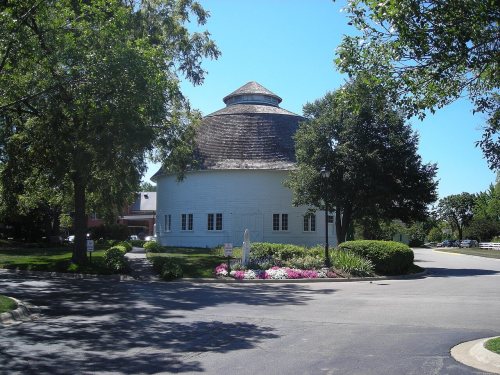
Most of Arlington Heights was built recently: 5% of its homes predate 1940 and the median home dates from 1974. Its Register listings are the Muller House, the Wheeler-Magnus Round Barn and the Nathaniel Moore Banta House. Below: 2 old photos and papers, maps from 1900 on, and the census since 1890.
The Arlington Heights post office opened in 1874, the earliest record of the town by name. Wikidata gives 1887. Another post office, Dunton (1861), opened inside today’s town and later closed.
First census: 1,424 in 18902020 census: 77,676152 years
How historic is Arlington Heights?
C+
More historic than 40% of U.S. towns, on its age, its old homes and the National Register.
Founding year: the first Arlington Heights post office (Blevins & Helbock, CC0). Wikidata: 1887.The full story ↓
History grade
What drives Arlington Heights’ History grade
On its age, its old homes and the National Register, Arlington Heights is more historic than 40% of U.S. towns, #461 of 768 in Illinois. Its National Register listings hold the grade up; its share of homes from before 1940 pulls it down.
C+
HistoryA character grade: shown, never part of Arlington Heights’ overall grade.
Few Illinois towns list much on the Register (a typical Illinois town has 0.5 per 10,000 residents, the U.S. 2.4), so Arlington Heights’ 0.5 sits near the middle of its state (60% of Illinois towns have fewer) while its 4 historic buildings outnumber those of 68% of U.S. towns.
How sure. Graded on any two of the three inputs instead, the letter would range from C− to B−. The pre-1940 share (±1.0 points) is firm at this size. The founding year is the first post office, not a stated founding date; Wikidata’s 1887 falls in the same era, so the grade doesn’t depend on which one is used.
Founding year: the first post office (other dates in Quick answers). Homes: Census ACS 2020–24. National Register: National Park Service, May 2026 list; each listing counted once (boundary changes and added documentation belong to their listing), and a historic district counts its contributing buildings. How TownRatings grades history →
What stands out about Arlington Heights’ past
Read from the archive, the National Register and the record. The page puts what stands out first.
Every edition of the U.S. Geological Survey’s map of Arlington Heights. Tap a year, or press play to watch the town change.
1900Highwood sheet · 1:62,500
U.S. Geological Survey historical topographic maps (public domain), via Esri’s collection of the scans. The red ring marks the center of Arlington Heights.
Famous people
41 famous people were born in Arlington Heights
Writers, athletes, leaders and more, ranked by how widely they’re known.
Arlington Heights lies mostly in the western part of Wheeling Township, with territory in adjacent Elk Grove and Palatine townships, in an area originally notable for the absence of groves and trees.
The land that is now Arlington Heights was controlled by the Miami Confederacy (which contained the Illini and Kickapoo tribes) starting in the early 1680s. The Confederacy was driven from the area by the Iroquois and Meskwaki in the early 1700s.
What they wrote about Arlington Heights, 1884–1909
Passages that mention Arlington Heights, cut from the printed page as they were published.
History of Cook County, Illinois1909 · page 275Read the page →
Read the text
The schoolhouse at Arlington Heights was built in 1849 and Miss Sarah Thornton was the first teacher in the same. This building was used until 1856, in which year a much better building was built. In 1870 a large brick structure was erected at a cost of about $10,000.
Text read by machine from the scan; it may contain errors.
History of Cook County, Illinois. From the earliest period to the present time1884 · page 505Read the page →
Read the text
in the town of Wheeling. He followed his trade for eight yean, which is that of a brick-layer, lie established his nursery business in l*iI2. He owns nine acres in the village of Arlington Heights, all sel lo BUfsMTJ Much end fruit. He has 5.000 Kiclimoml cherry tree* graded on Morello, anil 2(1,001) apple trees ill nursery stock : two acres set in hearing apple trees, Iwn acres In grape*. He has a large variety of small fruit, having raised 1511 liti-hels of currants in l*>2. and 115
Text read by machine from the scan; it may contain errors.
Scans and text from the Internet Archive. Books published in 1930 or earlier, which are in the public domain.
Timeline
Arlington Heights, 1861 to 1993
Woven from the archive, old maps, post office records, the National Register and the people born here.
Nothing in the archives for these yearsWeddings on Main Street, storms, parades, school pictures, the old store. If it’s in your family album, it belongs here.
Nothing in the archives for these yearsWeddings on Main Street, storms, parades, school pictures, the old store. If it’s in your family album, it belongs here.
The Arlington Heights post office opened in 1874, the earliest record of the town by name (U.S. post office records). Wikidata gives 1887.
How does Arlington Heights rank for history?
Arlington Heights is more historic than 40% of U.S. towns, #461 of 768 in Illinois. The History grade combines the town’s founding era, the share of homes built before 1940 and its National Register listings. It’s a character grade, so it isn’t part of the overall grade. How it works.
What is on the National Register in Arlington Heights?
Three places: the Muller House (listed 1979), the Wheeler-Magnus Round Barn (1992) and the Nathaniel Moore Banta House (1998).
How old are the homes in Arlington Heights?
5% of Arlington Heights’ homes were built before 1940 (Census estimate, ±1.0 points), against a typical 11% for an Illinois town; the median home was built in 1974.
Founding dates: Wikidata, Wikipedia, the U.S. post office records of Blevins & Helbock (CC0) and the Census. Homes by year built: Census ACS 2020–24. National Register of Historic Places: National Park Service (list of May 22, 2026). Old photos, postcards and papers: Wikimedia Commons, the Library of Congress and other public archives, credited on each item’s page. Maps: U.S. Geological Survey historical topographic maps (via Esri) and Sanborn fire-insurance maps (Library of Congress). History text and census tables: Wikipedia (CC BY-SA 4.0). Places that used to be: USGS Geographic Names Information System (2021).
From Wikimedia Commons (34), the National Register of Historic Places (3), Wikipedia, Wikidata and Wikipedia for famous people, U.S. Geological Survey historical maps, U.S. Census counts (via Wikipedia), the US Post Offices dataset (Blevins & Helbock), the USGS Geographic Names Information System and old county and town histories (Internet Archive). Archive images are copied here with their credits and licenses, shown on each photo’s page. Refreshed monthly.


 2013
 2013
 2013
 2012
 2012
 2012
 2012
 2012
 2012
 2012
 2012
 2012
 2012
 2012
 2012
 2012
 2012
 2012
 2012
 2012
 2012
 2012
 2012
 2012
 2012
 2012
 2012
 2011
 2010
 2009
 2009
 2005