McGregor dates to 1847, and 43% of its homes were built before 1940
6 places in town are on the National Register, among them two historic districts with 19 buildings between them. Below: 3 old photos and papers, maps from 1886 on, and the census since 1860.
Fire insurance maps drew every building, what it was made of and what it was used for, so insurers could price the risk of fire. Pick a year, then a sheet.
McGregor was founded as MacGregor's Landing in 1847 by Alexandar MacGregor of Clan Gregor, a descendant of Rob Roy MacGregor, and the area around MacGregor's Landing was settled by the extended family. In 1849 it was reported that the original MacGregor seal and signet were owned by Alex MacGregor. The Scots Gaelic clan seal was inscribed, "S' Riogal Mo Dhream/ Een dhn bait spair nocht", which was interpreted as "Royalty is my race / End do and spare not". The signet was a bloodstone from Loch Lomond, and was sketched by William Williams.
Passages that mention McGregor, cut from the printed page as they were published.
History of Clayton County, together with sketches of its cities, villages and townships ... biographies of representative citizens1882 · page 939Read the page →
Read the text
Hon. Eliphalet Price, County Judge, then issued a proclamation setting forth that “ the town of McGregor, in the'county of Clayton, and State of Iowa, is from and after the date of this proclamation an incorporated town, and that the legal voters thereof have full power and authority to elect their town officers, and do all other things as authorized by the charter of said town of McGregor.”
Text read by machine from the scan; it may contain errors.
History of Clayton County, Iowa1916 · page 179Read the page →
Read the text
McGregor During War — In 1862, through the efforts of Senator Hammer, a law was passed by the legislature establishing a city court for McGregor, and in September, 1863, McGregor was incorporated under a new law, abandoning the first charter under which it was incorporated in 1857. With the completion of the first portion of the railroad west of the Mississippi, the freight to be ferried from Mc- Gregor to Prairie du Chien grew enormously in bulk. In order to handle it, John Lawler, agent for the Milwaukee and Prairie du Chien
Text read by machine from the scan; it may contain errors.
History of Clayton County, Iowa1916 · page I29Read the page →
Read the text
McGregor Land Titles — At McGregor there was much building, but this was retarded by the uncertainty as to titles. Having won a decision in his suit against his brother, James McGregor, Jr., had notices served upon the business men of McGregor that they must either buy at his price, or sell to him. or be prepared to stand suit.
Text read by machine from the scan; it may contain errors.
Scans and text from the Internet Archive. Books published in 1930 or earlier, which are in the public domain.
Timeline
McGregor, 1847 to 1957
Woven from the archive, old maps, post office records, the National Register and the people born here.
In 1847, according to Wikipedia’s history of the town. McGregor’s post office opened in 1849, and the census of 1860 counted 1,989 people here.
What is on the National Register in McGregor?
6 listings: 4 buildings, among them the Reynolds, Joseph "Diamond Jo," Office Building and House (listed 1982, the first), and 2 historic districts, the McGregor Commercial Historic District and the American School of Wild Life Protection Historic District, with 19 contributing buildings. 24 historic buildings in all.
Founding dates: Wikidata, Wikipedia, the U.S. post office records of Blevins & Helbock (CC0) and the Census. Homes by year built: Census ACS 2020–24. National Register of Historic Places: National Park Service (list of May 22, 2026). Old photos, postcards and papers: Wikimedia Commons, the Library of Congress and other public archives, credited on each item’s page. Maps: U.S. Geological Survey historical topographic maps (via Esri) and Sanborn fire-insurance maps (Library of Congress). History text and census tables: Wikipedia (CC BY-SA 4.0). Places that used to be: USGS Geographic Names Information System (2021). How TownRatings grades history →
From Wikimedia Commons (13), the Library of Congress (4), Wikidata (1), the National Register of Historic Places (6), Wikipedia, Wikidata and Wikipedia for famous people, U.S. Geological Survey historical maps, U.S. Census counts (via Wikipedia), the US Post Offices dataset (Blevins & Helbock), the USGS Geographic Names Information System, Sanborn fire insurance maps (Library of Congress) and old county and town histories (Internet Archive). Archive images are copied here with their credits and licenses, shown on each photo’s page. Refreshed monthly.


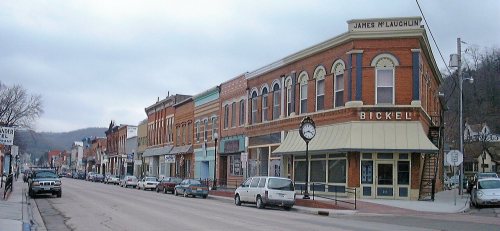


 Date?
 Date?
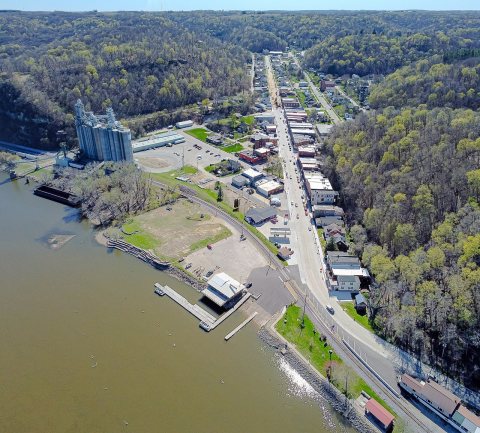 2024
 2016
 2016
 2016
 2016
 2016
 2016
 2010
 2010
 2010
 2005
 2004
 2003
 2003


