
The story
Read it all →How Gray came to be
From Wikipedia’s history of Gray.
Gray was laid out in 1881 by George Gray, and named for him. The Northwestern railroad was extended to the town in 1882.
Text from Wikipedia, licensed CC BY-SA 4.0.
Each edition grades its towns against each other only.
Below: maps from 1971 on and the census since 1900.
Gray dates its founding to 1881 (Wikipedia’s history). The census first counted it in 1900.
Read from the archive, the National Register and the record. The page puts what stands out first.
The first neighbors to add old photos shape how Gray’s history is told.
From Wikipedia’s history of Gray.
Gray was laid out in 1881 by George Gray, and named for him. The Northwestern railroad was extended to the town in 1882.
Text from Wikipedia, licensed CC BY-SA 4.0.
Passages that mention Gray, cut from the printed page as they were published.

Gray was named for its proprietor, George Gray. Towhead was the name of the high point of land three miles east of Exira. Years ago there were two oak trees there, which served as a landmark for miles around in most directions. The trees have long since vanished and the name is nearly obsolete.
Text read by machine from the scan; it may contain errors.
The following is a sketch of a plain, honest man of affairs who, by correct methods and a strict regard for the interests of his patrons, has made his influence felt in the town of Gray, this county, having won for himself distinctive prestige in the business circles of that pleasant village. He would be the last man to pose as a subject for romance or to court fanciful encomium ; nevertheless, his life presents much that is interesting and valuable and which may be studied with profit by the young men whose careers are yet to be made. Mr. Hepp is one of those men whose integrity and strength of
Text read by machine from the scan; it may contain errors.Scans and text from the Internet Archive. Books published in 1930 or earlier, which are in the public domain.
Woven from the archive, old maps, post office records, the National Register and the people born here.
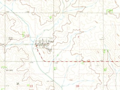 On the mapFirst mapped by the U.S. Geological Survey
Every edition of the U.S. Geological Survey’s map of Gray. Tap a year, or press play to watch the town change.

U.S. Geological Survey historical topographic maps (public domain), via Esri’s collection of the scans. The red ring marks the center of Gray.
Between 61 and 196 people in every census since 1900.
13 censuses, 1900–2020.
U.S. Census Bureau decennial counts, from the census table on Gray’s Wikipedia page.
Gray’s post office has been open since 1882.
US Post Offices dataset (Blevins & Helbock, CC0). Places and cemeteries from the USGS Geographic Names Information System (2021).
In 1881, according to Wikipedia’s history of the town. Gray’s post office opened in 1882, and the census of 1900 counted 180 people here.
What the archives can’t tell you, neighbors can.
Founding dates: Wikidata, Wikipedia, the U.S. post office records of Blevins & Helbock (CC0) and the Census. Homes by year built: Census ACS 2020–24. National Register of Historic Places: National Park Service (list of May 22, 2026). Old photos, postcards and papers: Wikimedia Commons, the Library of Congress and other public archives, credited on each item’s page. Maps: U.S. Geological Survey historical topographic maps (via Esri) and Sanborn fire-insurance maps (Library of Congress). History text and census tables: Wikipedia (CC BY-SA 4.0). Places that used to be: USGS Geographic Names Information System (2021). How TownRatings grades history →
From Wikimedia Commons (3), Wikipedia, U.S. Geological Survey historical maps, U.S. Census counts (via Wikipedia), the US Post Offices dataset (Blevins & Helbock), the USGS Geographic Names Information System and old county and town histories (Internet Archive). Archive images are copied here with their credits and licenses, shown on each photo’s page. Refreshed monthly.
 2021
 2020
 2004
