Cedar Falls dates to 1845, and 13% of its homes were built before 1940
More historic than 79% of U.S. towns · #51 of 140 in Iowa. What drives it
9 places in town are on the National Register, among them two historic districts with 43 buildings between them. Below: 5 old photos and papers, maps from 1885 on, and the census since 1870.
Founding year: Wikidata. First post office: 1850.The full story ↓
History grade
What drives Cedar Falls’ History grade
On its age, its old homes and the National Register, Cedar Falls is more historic than 79% of U.S. towns, #51 of 140 in Iowa. All 3 inputs are above most U.S. towns; its age ranks highest and its share of homes from before 1940 lowest.
A−
HistoryA character grade: shown, never part of Cedar Falls’ overall grade.
Iowa towns list more on the Register than most of the country (a typical Iowa town has 9.1 per 10,000 residents, the U.S. 2.4), so Cedar Falls’ 12.5 sits near the middle of its state (63% of Iowa towns have fewer) while its 51 historic buildings outnumber those of 85% of U.S. towns.
How sure. Graded on any two of the three inputs instead, the letter would range from B+ to A−. The pre-1940 share (±1.7 points) is firm at this size. Two sources give 1845.
Founding year: Wikidata (other dates in Quick answers). Homes: Census ACS 2020–24. National Register: National Park Service, May 2026 list; each listing counted once (boundary changes and added documentation belong to their listing), and a historic district counts its contributing buildings. How TownRatings grades history →
What stands out about Cedar Falls’ past
Read from the archive, the National Register and the record. The page puts what stands out first.
Cedar Falls’s post office has been open since 1850.
Hamlets and corners on the map
Cedar CityCedar Falls Mobile Home ParkCedar Falls Mobile Home VillageDietrick Mobile Home ParkFive Seasons Mobile Home ParkGas Light Mobile Home VillaHigh Acres Mobile Home ParkLamplighter VillaNorris SidingNorth Cedar
Gone or out of use
Lemons AirportairportUniversity of Northern Iowa Golf Courselocale
4cemeteries and burying grounds inside Cedar Falls
FairviewGreenwoodHillsidePet Haven
US Post Offices dataset (Blevins & Helbock, CC0). Places and cemeteries from the USGS Geographic Names Information System (2021).
Every building
Cedar Falls, building by building, 1885–1916
Fire insurance maps drew every building, what it was made of and what it was used for, so insurers could price the risk of fire. Pick a year, then a sheet.
The Cedar Valley was historically inhabited by Indigenous peoples, including the Sauk and Meskwaki (Fox). Euro-American settlement of the area that became Cedar Falls began in March 1845, when brothers-in-law William R. Sturgis and Erasmus D. Adams established a settlement along the Cedar River. Initially known as Sturgis Falls, the settlement was renamed Cedar Falls around 1850.
The settlement developed rapidly following the arrival of the Overman family. John M. and Dempsey C. Overman, together with their associates, established a water-powered sawmill in 1848. A gristmill was added in 1850, providing milling services to settlers from surrounding areas. Andrew Mullarky established an early general store near Main and First streets in 1850.
Passages that mention Cedar Falls, cut from the printed page as they were published.
Historical Record of Cedar Falls the Garden City of Iowa1893 · page 122Read the page →
Read the text
On March 18, 1855 the Rev. James Phillips met with six Cedar Falls residents in a one-room schoolhouse on the corner of 5th & Main and started the First Presbyterian Church in Cedar Falls. Services were held in several locations until a new church building, the first in Cedar Falls, was erected at 608 Main St. and dedicated on November 2, 1862. It had a pipe organ, the steeple housed a 1,200 Ib. bell and cost less than $6,000.
Text read by machine from the scan; it may contain errors.
Historical Record of Cedar Falls the Garden City of Iowa1893 · page 234Read the page →
Read the text
Valley View Baptist Church was chartered in May of 1960 by members of First Baptist Churches in Cedar Falls and Waterloo. First Baptist of Cedar Falls was overcrowded and needed to make a decision to continue the mission church meeting in Orchard Hill School, to relocate, or to open the way for a new church. The membership voted on the latter. A five acre tract of land in the southern part of Cedar Falls owned by First Baptist was given to the new congregation.
Text read by machine from the scan; it may contain errors.
Scans and text from the Internet Archive. Books published in 1930 or earlier, which are in the public domain.
Timeline
Cedar Falls, 1845 to 1971
Woven from the archive, old maps, post office records, the National Register and the people born here.
Nothing in the archives for these yearsWeddings on Main Street, storms, parades, school pictures, the old store. If it’s in your family album, it belongs here.
In 1845, according to Wikidata. Cedar Falls’ post office opened in 1850, and the census of 1870 counted 3,070 people here.
How does Cedar Falls rank for history?
Cedar Falls is more historic than 79% of U.S. towns, #51 of 140 in Iowa. The History grade combines the town’s founding era, the share of homes built before 1940 and its National Register listings. It’s a character grade, so it isn’t part of the overall grade. How it works.
What is on the National Register in Cedar Falls?
9 listings: 7 buildings, among them the Cedar Falls Ice House (listed 1977, the first), and 2 historic districts, the Cedar Falls Downtown Historic District and the Wild Historic District, with 43 contributing buildings. 51 historic buildings in all.
How old are the homes in Cedar Falls?
13% of Cedar Falls’ homes were built before 1940 (Census estimate, ±1.7 points), against a typical 22% for an Iowa town; the median home was built in 1975.
Founding dates: Wikidata, Wikipedia, the U.S. post office records of Blevins & Helbock (CC0) and the Census. Homes by year built: Census ACS 2020–24. National Register of Historic Places: National Park Service (list of May 22, 2026). Old photos, postcards and papers: Wikimedia Commons, the Library of Congress and other public archives, credited on each item’s page. Maps: U.S. Geological Survey historical topographic maps (via Esri) and Sanborn fire-insurance maps (Library of Congress). History text and census tables: Wikipedia (CC BY-SA 4.0). Places that used to be: USGS Geographic Names Information System (2021).
From Wikimedia Commons (2), the Library of Congress (3), the National Register of Historic Places (9), Wikipedia, Wikidata and Wikipedia for famous people, U.S. Geological Survey historical maps, U.S. Census counts (via Wikipedia), the US Post Offices dataset (Blevins & Helbock), the USGS Geographic Names Information System, Sanborn fire insurance maps (Library of Congress) and old county and town histories (Internet Archive). Archive images are copied here with their credits and licenses, shown on each photo’s page. Refreshed monthly.


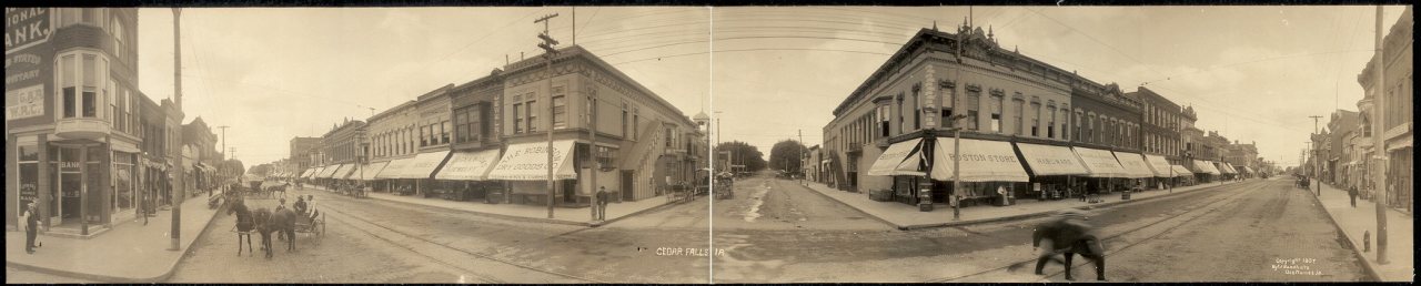


 1907
 1907
 1908


