Wethersfield dates to 1632, and 20% of its homes were built before 1940
More historic than 97% of U.S. towns · #11 of 155 in Connecticut. What drives it
5 places in town are on the National Register, among them 3 National Historic Landmarks and two historic districts with 1,207 buildings between them. Below: 9 old photos and papers, maps from 1893 on, and the census since 1820.
Founding year: Wikidata. First post office: 1794.The full story ↓
History grade
What drives Wethersfield’s History grade
On its age, its old homes and the National Register, Wethersfield is more historic than 97% of U.S. towns, #11 of 155 in Connecticut. All 3 inputs are above most U.S. towns; its age ranks highest and its share of homes from before 1940 lowest.
A+
HistoryA character grade: shown, never part of Wethersfield’s overall grade.
Connecticut towns list more on the Register than most of the country (a typical Connecticut town has 73.3 per 10,000 residents, the U.S. 2.4), so Wethersfield’s 444 sits above most of its state (93% of Connecticut towns have fewer) while its 1,210 historic buildings outnumber those of 99% of U.S. towns.
NoteThe founding year comes from Wikidata alone; no second source gives 1632.
How sure. Graded on any two of the three inputs instead, the letter would range from A to A+. The pre-1940 share (±2.8 points) is firm at this size.
Founding year: Wikidata (other dates in Quick answers). Homes: Census ACS 2020–24. National Register: National Park Service, May 2026 list; each listing counted once (boundary changes and added documentation belong to their listing), and a historic district counts its contributing buildings. How TownRatings grades history →
What stands out about Wethersfield’s past
Read from the archive, the National Register and the record. The page puts what stands out first.
Founded in 1634 by a Puritan settlement party of "10 Men", including John Oldham, Robert Seeley, Thomas Topping, and Nathaniel Foote, Wethersfield is arguably the oldest town in Connecticut, depending on the interpretation of when a remote settlement qualifies as a "town". Along with Windsor and Hartford, Wethersfield is represented by one of the three grapevines on the Flag of Connecticut, signifying the state's three oldest English settlements. The town was named by colonists for Wethersfield, a village in the English county of Essex. The town was previously called "Watertown", named after Watertown, Massachusetts, until February 21, 1637, when it was incorporated as a town along with Windsor and Hartford. The town established the Old Wethersfield Village Cemetery as its first burying ground on Hungry Hill in 1638.
Passages that mention Wethersfield, cut from the printed page as they were published.
The history of ancient Wethersfield1900 · page 361Read the page →
Read the text
Schools and Districts of Old or First Parish of Wethersfield.— At a Town Meeting in Wethersfield, March 2d, 1723-4, it was voted that the “northern inhabitants of the First Society in said Town” might erect a small school house, “somewhere near the northwest end of Standishes Lane, so as not to prejudice the highway thereby.” Thus it is seen that the Town, even in the First, or Old Society, directed in the matter of the schools. As School Districts were unknown, the new school house should be considered as a branch of the school house of
Text read by machine from the scan; it may contain errors.
The history of ancient Wethersfield1900 · page 875Read the page →
Read the text
the lines as they now exist, except that the north district extended up to the north line of Stepney parish, and the north line of the west district was on the old parish line at that end of the parish. That part of the north district now in the town of Wethersfield, except the first house north of the bridge, was at a later day set off to Harris Hill district of Wethersfield, and about 1860 the district line was brought to the town line and the north line of the west district was extended in 1850 north to coincide with the line between the towns. At this period
Text read by machine from the scan; it may contain errors.
Scans and text from the Internet Archive. Books published in 1930 or earlier, which are in the public domain.
By decade
Wethersfield, decade by decade
5 decades in the archive, from the 1860s to the 1930s. Scroll each row; tap a photo for its story.
Nothing in the archives for these yearsWeddings on Main Street, storms, parades, school pictures, the old store. If it’s in your family album, it belongs here.
In 1632, according to Wikidata. Wethersfield’s post office opened in 1794, and the census of 1820 counted 3,825 people here.
How does Wethersfield rank for history?
Wethersfield is more historic than 97% of U.S. towns, #11 of 155 in Connecticut. The History grade combines the town’s founding era, the share of homes built before 1940 and its National Register listings. It’s a character grade, so it isn’t part of the overall grade. How it works.
What is on the National Register in Wethersfield?
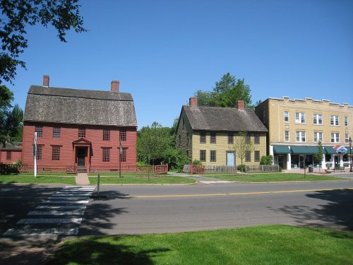
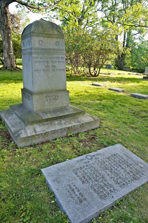
5 listings, 3 of them National Historic Landmarks: 3 buildings, among them the Joseph Webb House (a National Historic Landmark since 1962), and 2 historic districts, the Old Wethersfield Historic District and the Cedar Hill Cemetery, with 1,207 contributing buildings. 1,210 historic buildings in all.
How old are the homes in Wethersfield?
20% of Wethersfield’s homes were built before 1940 (Census estimate, ±2.8 points), against a typical 15% for a Connecticut town; the median home was built in 1960.
Founding dates: Wikidata, Wikipedia, the U.S. post office records of Blevins & Helbock (CC0) and the Census. Homes by year built: Census ACS 2020–24. National Register of Historic Places: National Park Service (list of May 22, 2026). Old photos, postcards and papers: Wikimedia Commons, the Library of Congress and other public archives, credited on each item’s page. Maps: U.S. Geological Survey historical topographic maps (via Esri) and Sanborn fire-insurance maps (Library of Congress). History text and census tables: Wikipedia (CC BY-SA 4.0). Places that used to be: USGS Geographic Names Information System (2021).
From Wikimedia Commons (22), the Library of Congress (6), the National Register of Historic Places (5), Wikipedia, Wikidata and Wikipedia for famous people, U.S. Geological Survey historical maps, U.S. Census counts (via Wikipedia), the US Post Offices dataset (Blevins & Helbock), the USGS Geographic Names Information System and old county and town histories (Internet Archive). Archive images are copied here with their credits and licenses, shown on each photo’s page. Refreshed monthly.


 ★ Landmark
 ★ Landmark
 ★ Landmark


 1869
 1869
 1901
 1936
 2014
 2012
 2011
 2011
 2011
 2011
 2011
 2011
 2011
 2011
 2011
 2011
 2011
 2011
 2010
 2009
 2009
 2009
 2007


