 Local
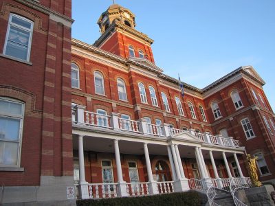
Cited heritage site (Québec)Collège Saint-Alexandre de la Gatineauchemin des Érables¤ rue Saint-LouisPhoto: Ricebiscuit · CC BY-SA 4.0 · Commons file
 Collège Saint-Alexandre de la Gatineau · Photo: Ricebiscuit · CC BY-SA 4.0
1historic place on the registers
History of Les Rapides · Canada’s heritage registers
Les Rapides has 1 historic place on the registers
Homes from before 1961 are 1.7% of the stock, under the 18% of the typical town. Les Rapides has 0.7 for every 10,000 people, a higher rate than 76% of Canadian towns.
Historic places
1
0.7 per 10,000 residents
Highest designations
0
National Historic Sites, classified federal buildings and Québec’s classements
Provincial and local listings
1
municipal citations on Québec’s register
Homes built before 1961
1.7%
typical town: 18%
Through time
Looking back at Les Rapides
A single old picture: the oldest view of one of its historic places. Tap the picture to enlarge it.
 c. 1920
Public domain or CC0, made before 1950, from Wikimedia Commons; old views of places can be drawings, prints or maps of their time. Each credit opens the image’s page.
The map
Where Les Rapides’s history is
Every place on the registers inside the town, by its designation.
Provincial and local listings
Hover a dot for its name; tap one to open its page.
The 1, by tier
1 Provincial and local listings
Two open registers meet here: Parks Canada’s Directory of Federal Heritage Designations and Québec’s heritage register, which records both provincial classements and municipal citations.
Points from Wikidata (Parks Canada’s files carry none) and from Québec’s register, as mapped there.
Provincial and local listings
On a provincial or local list in Les Rapides: one place
Citations the municipality has made, registered with Québec’s ministry of culture. Each one opens its own page.
The age of the area
Near Les Rapides (10 km around), the dated heritage is mostly from the decades after Confederation
Places near Les Rapides (within 10 km, outside the town), each by the first construction date it records.
British North America 1760–186625
After Confederation 1867–191344
Wars and Depression 1914–194518
Since 1946 1946 on9
96 places within 10 km have a date. 25 go back before 1867. Saint James cemetery, in Du Parc, goes back furthest, to 1820.
Around the town
104 designated places lie within 10 km of Les Rapides
They are 36 Recognized Federal Heritage Buildings, 20 municipal citations and 20 National Historic Sites. The oldest, Saint James cemetery, dates from 1820, 8.1 km away. Centretown, Centre-Ville and Lowertown West hold most of them, among 12 towns.
The 12 nearest, within 10 km
| Site du patrimoine Jacques-CartierCited heritage site (Québec) · 4.6 km away, in Centre-Ville |
| Cimetière des Pionniers de ChelseaCited heritage site (Québec) · 1837 · 4.6 km away, in Chelsea |
| Blocks 2000-2700Recognized Federal Heritage Building · 1963–1969 · 5.3 km away, in Du Plateau |
| Blocks 1200-1900Recognized Federal Heritage Building · 1963–1969 · 5.4 km away, in Du Plateau |
| Blocks 100-1100Recognized Federal Heritage Building · 1963–1969 · 5.5 km away, in Du Plateau |
| Fairview HouseClassified heritage building (Québec) · 1862–1863 · 5.7 km away, in Lac-des-Fées |
| Columbia FarmMunicipal citation (Québec) · 1835 · 5.8 km away, in Lac-des-Fées |
| Old Chease Protestant CemeteryCited heritage site (Québec) · 1835 · 5.9 km away, in Chelsea |
| Gilmour and Hughson Limited OfficeRecognized Federal Heritage Building · 1892–1893 · 6.4 km away, in Centre-Ville |
| StornowayRecognized Federal Heritage Building · 1913–1915 · 6.6 km away, in Manor Park |
| Prime Minister's ResidenceClassified Federal Heritage Building · 1867–1869 · 6.6 km away, in New Edinburgh |
| Radmore Estate HouseMunicipal citation (Québec) · 1871 · 6.7 km away, in Du Plateau |
Homes by age
Les Rapides’s building boom came from 1981 to 2000: 45% of its homes
More than half of Les Rapides’s housing predates 2001. Les Rapides has an unusual share of homes built from 2001 to 2015: 28%, where most towns have 15%. New building has been slow in Les Rapides: 2.9% of homes date from 2016–21, where most towns have 4.1%.
1.7%
Before 1961
20%
1961–80
45%
1981–2000
28%
2001–15
2.9%
2016–21
Les RapidesTypical town
2021 Census, private dwellings by period of construction (Statistics Canada); the typical town is the middle Canadian town of 2,500 or more.
Towns its size
Les Rapides has the 3rd most of 16 towns its size
Towns of 15,000 to 15,200 residents, by places on the registers.
Les Rapides1
Ahead of it: Pointe-Saint-Charles and Saint-Vincent-de-Paul. Their median is 0. 12 of them have none.
Neighbours
Les Rapides and its neighbours
| Town | People | Places | Highest | Oldest |
|---|---|---|---|---|
| Les Rapides | 15,090 | 1 | 0 | — |
| La Cité | 30,930 | 0 | 0 | — |
| Hautes-Plaines | 6,353 | 0 | 0 | — |
| Rivière-Gatineau | 14,875 | 0 | 0 | — |
| Mont-Bleu | 21,636 | 0 | 0 | — |
| Lac-des-Fées | 10,075 | 3 | 1 | 1835 |
| Du Moulin | 30,364 | 1 | 0 | — |
In brief
Les Rapides in brief
All told, Les Rapides has 1 historic place. Only 2 of the 16 towns nearest its size have more historic places. The census dates only 1.7% of its homes before 1961, against 18% in the typical town. For the rest, its designation dates from 2006.
How to read these numbers
What this data can and can’t tell you
- The federal register. Parks Canada’s Directory of Federal Heritage Designations lists every National Historic Site, federal heritage building, heritage railway station and lighthouse; the Canadian Register of Historic Places adds their statements in English and French.
- Québec’s register. Québec’s Répertoire du patrimoine culturel records the province’s classements and declarations and every municipal citation, each with a description and a point.
- People and events. The open directory puts its national historic persons nowhere, so a town shows one only on firm ground: a birth there, matched by name and life years, or a historic place there named for the person whose record says so. Events are left out.
- Protection. In Québec, a classement or a municipal citation under the Loi sur le patrimoine culturel protects the building in law; a federal designation recognises significance and binds only federal owners.
- The tiers. Tiers follow the designation: national recognition and classement first, other federal designations next, provincial and local listings last.
- The grade. There is no history grade: the page sets out the record and compares it with other towns.
Questions about Les Rapides’s history
How many historic places does Les Rapides have on the registers?
1 historic place in Les Rapides, from Canada’s heritage registers.
How old are the homes in Les Rapides?
The 2021 Census dates 1.7% of its homes before 1961 (18% in the typical town).
Contains information licensed under the Open Government Licence – Canada (Parks Canada). Québec register data: Ministère de la Culture et des Communications du Québec, CC BY 4.0.
Sources: Parks Canada, Directory of Federal Heritage Designations · Canadian Register of Historic Places (federal extract) · Répertoire du patrimoine culturel du Québec (MCC, Données Québec) · Wikidata (CC0) for map points, other names and articles · Statistics Canada, 2021 Census (homes by period of construction). Under the Statistics Canada Open Licence.
Adapted from Statistics Canada (Census of Population 2021, population estimates 2025, 2021 census boundaries) under the Statistics Canada Open Licence; this does not constitute an endorsement by Statistics Canada. Neighbourhood names in some cities © OpenStreetMap contributors (ODbL).