
 Top
National Historic Site · 1912–1914Smiths Falls Bascule Bridge5 Abbot StreetPhoto: D. Gordon E. Robertson · CC BY-SA 3.0 · Commons file
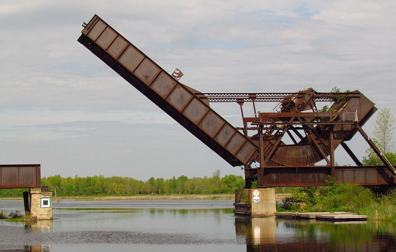 Smiths Falls Bascule Bridge · Photo: D. Gordon E. Robertson · CC BY-SA 3.0
4historic places on the registers
History of Smiths Falls · Canada’s heritage registers
56% of Smiths Falls’s homes were built before 1961
The typical town has 18%: Smiths Falls has 3.2 times the share. The lists give 4 historic places here, 2 in the top tier. Per resident it outdoes 92% of Canadian towns, with 3.6 for every 10,000 people. Its oldest building on the record is West Mill, from 1852.
Historic places
4
3.6 per 10,000 residents
Highest designations
2
National Historic Sites and Classified Federal Heritage Buildings
Other federal designations
2
Recognized buildings, railway stations, lighthouses
Oldest building
1852
the first construction date on its record
Homes built before 1961
56%
typical town: 18%
In pictures
Photos of all 2 top-tier places in Smiths Falls
2 designated places in Smiths Falls have a photo. Up first are Smiths Falls Bascule Bridge and Smiths Falls Railway Station (Canadian Northern). The oldest place in Smiths Falls’s set dates from 1912: Smiths Falls Bascule Bridge.
Photos from Wikimedia Commons, each credited to its photographer with its licence; names open the place’s page. Tap a photo to step through them full screen.
The map
Where Smiths Falls’s history is
Every place on the registers inside the town, by its designation.
Highest designations
Names show on hover, and a tap takes you to the place’s page.
The 4, by tier
2 Highest designations2 Other federal designations
The federal directory kept by Parks Canada supplies most of these places; provincial and municipal lists outside Québec aren’t open data, so only the ones Wikidata documents with an article appear.
Points from Wikidata (Parks Canada’s files carry none) and from Québec’s register, as mapped there. 2 places, placed by their register’s municipality, have no point and aren’t on the map.
Highest designations
2 places in Smiths Falls with the highest designation
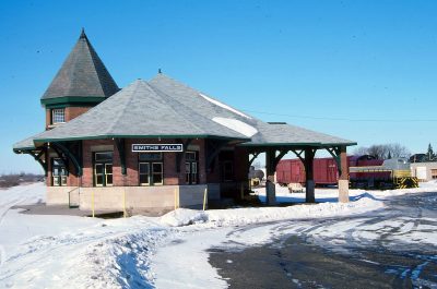
National Historic Sites and Classified Federal Heritage Buildings, Canada’s highest federal recognition. Among them: Smiths Falls Bascule Bridge and Smiths Falls Railway Station (Canadian Northern). Each one opens its own page.
 Top
National Historic Site · 1912–1915Smiths Falls Railway Station (Canadian Northern)90 William Street WestPhoto: Bruce Fingerhood from Springfield, Oregon, US · CC BY 2.0 · Commons file
Other federal designations
2 more federal designations in Smiths Falls
Recognized Federal Heritage Buildings, heritage railway stations and lighthouses. The oldest, West Mill, dates from 1852; the newest from 1890. Each one opens its own page.
Homes by age
Smiths Falls added few homes from 2016 to 2021: 2.9%, where most towns have 4.1%
Only 5% of Smiths Falls’s homes were built from 2001 to 2015, less than the typical town’s 15%. Smiths Falls built little from 1981 to 2000: 12% of its homes, where most towns have 23%. Half of the homes standing in Smiths Falls today were built before 1961.
56%
Before 1961
24%
1961–80
12%
1981–2000
5%
2001–15
2.9%
2016–21
Smiths FallsTypical town
2021 Census, private dwellings by period of construction (Statistics Canada); the typical town is the middle Canadian town of 2,500 or more.
Born here
Smiths Falls’s people of the past, born 1843–1912
Counting only births before 1914, there are 8. Francis Theodore Frost is the most written about, in 4 languages. The longest life was Conway Farrell’s: 90 years, to 1988. Of the 8, 5 were born in the decades after Confederation.
Francis Theodore Frost
Nicholas Bawlf
John Warwick King
E. A. Gilroy
Roy Theodore Graham
William Benson Craig
Conway Farrell
Desmond Code
1800182518501875190019251950

Francis Theodore Frost1843–1916 · Manufacturer and politician
JK
John Warwick King1856–1927 · Canadian politician
CF
Conway Farrell1898–1988 · Fighter pilot
RG
Roy Theodore Graham1887–1965 · Canadian politician
WC
William Benson Craig1896–1918 · Canadian flying ace
DC
Desmond Code1912–1980 · Canadian politician
NB
Nicholas Bawlf1849–1914 · Canadian businessman

E. A. Gilroy1879–1942 · Canadian ice hockey administrator
Everyone born in Smiths Falls → Born before 1914 (the page’s periods: Confederation to the First World War). Birthplaces from Wikidata, each checked against the person’s Wikipedia article.
Towns its size
Smiths Falls has the most of 16 towns its size
Towns of 11,000 to 11,200 residents, by places on the registers.
Smiths Falls4
The typical town its size has 0. For 14, the registers list nothing.
Neighbours
Smiths Falls and its neighbours
| Town | People | Places | Highest | Oldest |
|---|---|---|---|---|
| Smiths Falls | 11,093 | 4 | 2 | 1852 |
| Montague | 4,414 | 0 | 0 | — |
| Merrickville | 3,411 | 2 | 1 | 1832 |
| Drummond/North Elmsley | 8,817 | 0 | 0 | — |
| Perth | 6,972 | 3 | 3 | 1830 |
In brief
Smiths Falls in brief
The pre-1961 share of Smiths Falls’s homes is 56%, against 18% in the typical town. In all there are 4 historic places, 2 with the highest designation. It tops the 16 towns nearest its size for historic places. Francis Theodore Frost (1843), John Warwick King (1856) and Conway Farrell (1898) lead its people of the past. Beyond that, the list grew between 1983 and 1988.
How to read these numbers
What this data can and can’t tell you
- Map points. Where a federal place sits on the map is Wikidata’s placing; the directory itself has no coordinates.
- The federal register. The federal list is complete and open: Parks Canada’s directory for the designations, the Canadian Register of Historic Places for what each one is and why it matters.
- Protection. National historic designation honours a place but binds only federal owners; a private building’s protection depends on its province or municipality.
- The tiers. Three tiers: the top for National Historic Sites, classified federal buildings and Québec’s classements, a second for the other federal designations, a third for provincial and municipal listings.
- Provincial and municipal lists. Outside Québec, provinces’ and municipalities’ heritage registers aren’t open data; their places are known only through Wikidata items with a register number, and only those with an encyclopedia article get a page.
- The grade. History is described, not graded, for every Canadian town.
- People and events. National historic persons carry no place in the open file. They appear on a town’s page when born there (same name, same birth and death years) or when a historic place inside it carries their name and its record names them with their dates; national historic events don’t appear.
Questions about Smiths Falls’s history
How old are the homes in Smiths Falls?
56% predate 1961, where the typical town has 18%.
Which places in Smiths Falls have the highest designation?
Smiths Falls Bascule Bridge and Smiths Falls Railway Station (Canadian Northern).
What is the oldest building in Smiths Falls?
West Mill — its record dates it to 1852 (Recognized Federal Heritage Building).
Why might a heritage building in Smiths Falls be missing here?
Only federal designations are fully open outside Québec. 2 more listings in Smiths Falls are known through Wikidata alone, so they are counted, not paged.
Contains information licensed under the Open Government Licence – Canada (Parks Canada).
Sources: Parks Canada, Directory of Federal Heritage Designations · Canadian Register of Historic Places (federal extract) · Wikidata (CC0) for map points, other names and articles · Statistics Canada, 2021 Census (homes by period of construction). Under the Statistics Canada Open Licence.
Adapted from Statistics Canada (Census of Population 2021, population estimates 2025, 2021 census boundaries) under the Statistics Canada Open Licence; this does not constitute an endorsement by Statistics Canada. Neighbourhood names in some cities © OpenStreetMap contributors (ODbL).