Cliff Site
In French: Site de la falaise
21 Brown Street near Highway 6, Simcoe
About Cliff Site
Cliff Site is one of 4 National Historic Sites in Simcoe. Cliff Site went up in 1669.
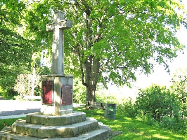
Cliff Site National Historic Site of Canada, located on Brant Hill in Port Dover, Ontario, overlooks Highway 6, along the north shore of Lake Erie. The site is marked by a large memorial cross. A cross on a pedestal resting on octogonal steps, this monument bears a Historic Sites and Monuments Board of Canada plaque, as well as a secondary plaque, commemorating a 1670 cross raising of which there are no extant remains. Official recognition refers to the current site of the cross surrounded by a five metre radius.
From the Canadian Register of Historic Places, Cliff Site National Historic Site of Canada · Open Government Licence – Canada · as published, word for word
A National Historic Site is designated by the federal minister on the Historic Sites and Monuments Board’s advice.
1 old view of Cliff Site
Made before 1950, from 1923: public domain or CC0. Tap one to see it full screen.
 c. 1923
From Wikimedia Commons, copied to our own server; some are drawings, prints or maps of their time. Each credit is in the viewer.
Finding Cliff Site
Simcoe


It is a stop on its own: the next historic place is a longer trip.
Questions about Cliff Site
When was Cliff Site built?
The register dates the construction of Cliff Site to 1669.
What is Cliff Site?
A National Historic Site: Canada designated Cliff Site in 1919.
Can you visit Cliff Site?
From outside, yes; going in depends on who owns or runs it.
Is Cliff Site protected?
National Historic Site status commemorates; legal protection, where there is any, comes from the province or municipality, or from federal ownership.
Contains information licensed under the Open Government Licence – Canada (Parks Canada).
Sources: Parks Canada, Directory of Federal Heritage Designations · Canadian Register of Historic Places (federal extract) · Photos: Wikimedia Commons, each credited with its licence and copied to our own server · Wikidata (CC0) for map points, other names and articles.
Adapted from Statistics Canada (Census of Population 2021, population estimates 2025, 2021 census boundaries) under the Statistics Canada Open Licence; this does not constitute an endorsement by Statistics Canada. Neighbourhood names in some cities © OpenStreetMap contributors (ODbL).