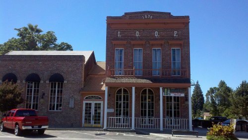
Woodbridge dates to 1852, and 2 of its places are on the National Register
More historic than 40% of U.S. towns · #220 of 847 in California. What drives it
Most of Woodbridge was built recently: 3% of its homes predate 1940 and the median home dates from 1985. Its Register listings are the I.O.O.F. Hall and the Woodbridge Masonic Lodge No. 131. Its Register listings are the I.O.O.F. Hall and the Woodbridge Masonic Lodge No. 131. Below: 6 old photos and papers, maps from 1884 on, and the census since 1970.
Founding year: Wikipedia. First post office: 1857.The full story ↓
History grade
What drives Woodbridge’s History grade
On its age, its old homes and the National Register, Woodbridge is more historic than 40% of U.S. towns, #220 of 847 in California. Its National Register listings hold the grade up; its share of homes from before 1940 pulls it down.
C+
HistoryA character grade: shown, never part of Woodbridge’s overall grade.
Few California towns list much on the Register (a typical California town has 0.0 per 10,000 residents, the U.S. 2.4), so Woodbridge’s 4.8 sits above most of its state (87% of California towns have fewer) while its 2 listings outnumber those of 60% of U.S. towns.
How sure. Graded on any two of the three inputs instead, the letter would range from C− to B. The pre-1940 share is a Census survey estimate (±3.4 points). Two sources give 1852.
Founding year: Wikipedia (other dates in Quick answers). Homes: Census ACS 2020–24. National Register: National Park Service, May 2026 list; each listing counted once (boundary changes and added documentation belong to their listing), and a historic district counts its contributing buildings. How TownRatings grades history →
What stands out about Woodbridge’s past
Read from the archive, the National Register and the record. The page puts what stands out first.
Every edition of the U.S. Geological Survey’s map of Woodbridge. Tap a year, or press play to watch the town change.
1910Woodbridge sheet · 1:31,680
U.S. Geological Survey historical topographic maps (public domain), via Esri’s collection of the scans. The red ring marks the center of Woodbridge.
Every building
Woodbridge, building by building, 1884–1895
Fire insurance maps drew every building, what it was made of and what it was used for, so insurers could price the risk of fire. Pick a year, then a sheet.
1884Sheet 1 of 1
Edition
Sheets
BrickWoodStone
Sanborn Map Company, via the Library of Congress. Editions published in 1930 or earlier, which are in the public domain.
Woodbridge was founded in 1852 by Jeremiah H. Woods and Alexander McQueen, who established a ferry across the Mokelumne River. The ferry enabled a new road to be routed between Stockton and Sacramento. In 1858 they built a wooden bridge at the site of the ferry which became known as Woods' Bridge, from which the community drew its name. Woods hoped that the settlement would grow larger than Stockton, and even hoped to form a separate county, Mokelumne County, with Woodbridge as the seat. In 1867, however, the railroad chose to bypass Woodbridge and lay tracks through neighboring Lodi instead.
Passages that mention Woodbridge, cut from the printed page as they were published.
History of San Joaquin County, California1923 · page 1032Read the page →
Read the text
Frank De La Ralls received his earl}' education in the Woodbridge grammar school, and then entered the San Joaquin Valley College, completing his education at the age of fifteen, when he took up the butcher trade at Woodbridge. He worked for Thompson & Folger in their shop in Woodbridge for eight years; then became associated with the Earl Fruit Company of Lodi as a clerk, and lafer as outside man,
Text read by machine from the scan; it may contain errors.
History of San Joaquin County, California1923 · page 293Read the page →
Read the text
ing that point, as he considered it a very important business proposition, which it was, if successful. In the meantime J. H. Woods, the founder of Woodbridge, did not propose to have the rival town of Lockeford be declared the head of navigation, and he bribed the captain of the Fanny Ann to loaf on the job and cast anchor at Woodbridge. The stearner
Text read by machine from the scan; it may contain errors.
An Illustrated history of San Joaquin County, California1890 · page 452Read the page →
Read the text
British Columbia he made his way there and mined one season. From 1865 up to 1869 he was connected with the butcher business of Thompson & Folger, of Woodbridge. Four years he was engaged in a flouring mill at Woodbridge. In 1874 he purchased his present ranch of 160 acres of choice farming land in Liberty Township, wiiere he has made his
Text read by machine from the scan; it may contain errors.
An Illustrated history of San Joaquin County, California1890 · page 544Read the page →
Read the text
From this city he went to live with his uncle, Jeremiah H.Woods, the founder of Woodbridge, and from whom it received its name. Early in 1858 he became the owner of 320 acres northeast of Woodbridge, on a portion of which the villao-e of Acampo now stands. In 1859 he engaged in mercantile business with a Mr. Porch, under the style of Porch & Woods. He sold
Text read by machine from the scan; it may contain errors.
Scans and text from the Internet Archive. Books published in 1930 or earlier, which are in the public domain.
Timeline
Woodbridge, 1852 to 1933
Woven from the archive, old maps, post office records, the National Register and the people born here.
Nothing in the archives for these yearsWeddings on Main Street, storms, parades, school pictures, the old store. If it’s in your family album, it belongs here.
In 1852, according to Wikipedia’s history of the town. Woodbridge’s post office opened in 1857, and the census of 1970 counted 1,397 people here.
How does Woodbridge rank for history?
Woodbridge is more historic than 40% of U.S. towns, #220 of 847 in California. The History grade combines the town’s founding era, the share of homes built before 1940 and its National Register listings. It’s a character grade, so it isn’t part of the overall grade. How it works.
What is on the National Register in Woodbridge?
Two places: the I.O.O.F. Hall (listed 1982) and the Woodbridge Masonic Lodge No. 131 (1989).
How old are the homes in Woodbridge?
3% of Woodbridge’s homes were built before 1940 (Census estimate, ±3.4 points), against a typical 3.4% for a California town; the median home was built in 1985.
Founding dates: Wikidata, Wikipedia, the U.S. post office records of Blevins & Helbock (CC0) and the Census. Homes by year built: Census ACS 2020–24. National Register of Historic Places: National Park Service (list of May 22, 2026). Old photos, postcards and papers: Wikimedia Commons, the Library of Congress and other public archives, credited on each item’s page. Maps: U.S. Geological Survey historical topographic maps (via Esri) and Sanborn fire-insurance maps (Library of Congress). History text and census tables: Wikipedia (CC BY-SA 4.0). Places that used to be: USGS Geographic Names Information System (2021).
From Wikimedia Commons (6), the National Register of Historic Places (2), Wikipedia, Wikidata and Wikipedia for famous people, U.S. Geological Survey historical maps, U.S. Census counts (via Wikipedia), the US Post Offices dataset (Blevins & Helbock), the USGS Geographic Names Information System, Sanborn fire insurance maps (Library of Congress) and old county and town histories (Internet Archive). Archive images are copied here with their credits and licenses, shown on each photo’s page. Refreshed monthly.


 1933
 1933
 1933
 1933
 1933