More historic than 15% of U.S. towns · #593 of 847 in California. What drives it
Most of San Marcos was built recently: 0.5% of its homes predate 1940 and the median home dates from 1996. Below: maps from 1893 on and the census since 1970.
The San Marcos post office opened in 1888, the earliest record of the town by name. Wikidata gives 1963. Two smaller post offices, Twin Oaks (1889) and Richland (1894), opened inside today’s city and later closed.
First census: 3,896 in 19702020 census: 94,833138 years
How historic is San Marcos?
D
More historic than 15% of U.S. towns, on its age, its old homes and the National Register.
Founding year: the first San Marcos post office (Blevins & Helbock, CC0). Wikidata: 1963.The full story ↓
History grade
What drives San Marcos’ History grade
On its age, its old homes and the National Register, San Marcos is more historic than 15% of U.S. towns, #593 of 847 in California. Its age holds the grade up; its share of homes from before 1940 pulls it down.
D
HistoryA character grade: shown, never part of San Marcos’ overall grade.
Few California towns list much on the Register (a typical California town has 0.0 per 10,000 residents, the U.S. 2.4), so San Marcos’ 0.0 sits below most of its state (31% of California towns have fewer) while its 0 listings outnumber those of 23% of U.S. towns.
How sure. Graded on any two of the three inputs instead, the letter would range from D to C−. The pre-1940 share (±0.2 points) is firm at this size. The founding year is the first post office, not a stated founding date; Wikidata gives 1963.
Founding year: the first post office (other dates in Quick answers). Homes: Census ACS 2020–24. National Register: National Park Service, May 2026 list; each listing counted once (boundary changes and added documentation belong to their listing), and a historic district counts its contributing buildings. How TownRatings grades history →
What stands out about San Marcos’ past
Read from the archive, the National Register and the record. The page puts what stands out first.
Lost post offices, old corners and burying grounds
San Marcos’s post office has been open since 1888. Two other post offices opened and closed inside today’s town.
San Marcos
1888–today
Twin Oaks
1889–1901
Richland
1894–1905
18801950today
Hamlets and corners on the map
Casitas del Sol Mobile Home ParkFoothills of San Marcos Mobile Home ParkLaMoree Mobile EstatesMadrid Manor Mobile Home ParkPalomar East Mobile Home ParkPalomar West Mobile Home ParkRichlandSan Marcos Mobile EstatesTwin Oaks
2cemeteries and burying grounds inside San Marcos
Meadowlark Pioneer MemorialSan Marcos
US Post Offices dataset (Blevins & Helbock, CC0). Places and cemeteries from the USGS Geographic Names Information System (2021).
On the map
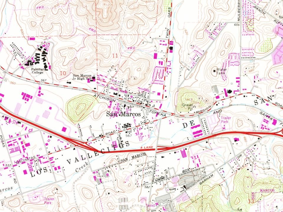
San Marcos on the map, 1893 to 1996
Every edition of the U.S. Geological Survey’s map of San Marcos. Tap a year, or press play to watch the town change.
1893Escondido sheet · 1:62,500
U.S. Geological Survey historical topographic maps (public domain), via Esri’s collection of the scans. The red ring marks the center of San Marcos.
According to some historical legends, the San Luis Rey Mission flocks were robbed by a small band of Native Americans in the late 18th century. Fleeing the Spanish troops, the Native Americans escaped to the hills. While pursuing the Native Americans in 1797 the Spaniards came upon a fertile valley, which was named Los Vallecitos de San Marcos (Little Valleys of Saint Mark) to honor the day of discovery: April 25, St. Mark’s Day. On April 22, 1840, Governor Juan B. Alvarado granted Rancho Vallecitos de San Marcos to his relative, Jose María Alvarado. Jose Alvarado was killed at the Pauma Massacre in 1846, and the land was left to his wife; she then sold the land to Lorenzo Soto. In the late 1850s, Soto sold part of his land to Cave Couts, and his family was soon raising livestock. Although Cave Couts owned the land, Major Gustavus French Merriam from Topeka, Kansas, made the first perma…
The San Marcos post office opened in 1888, the earliest record of the town by name (U.S. post office records). Wikidata gives 1963.
How does San Marcos rank for history?
San Marcos is more historic than 15% of U.S. towns, #593 of 847 in California. The History grade combines the town’s founding era, the share of homes built before 1940 and its National Register listings. It’s a character grade, so it isn’t part of the overall grade. How it works.
How old are the homes in San Marcos?
0.5% of San Marcos’ homes were built before 1940 (Census estimate), against a typical 3.4% for a California town; the median home was built in 1996.
Founding dates: Wikidata, Wikipedia, the U.S. post office records of Blevins & Helbock (CC0) and the Census. Homes by year built: Census ACS 2020–24. National Register of Historic Places: National Park Service (list of May 22, 2026). Old photos, postcards and papers: Wikimedia Commons, the Library of Congress and other public archives, credited on each item’s page. Maps: U.S. Geological Survey historical topographic maps (via Esri) and Sanborn fire-insurance maps (Library of Congress). History text and census tables: Wikipedia (CC BY-SA 4.0). Places that used to be: USGS Geographic Names Information System (2021).
From Wikimedia Commons (1), Wikipedia, Wikidata and Wikipedia for famous people, U.S. Geological Survey historical maps, U.S. Census counts (via Wikipedia), the US Post Offices dataset (Blevins & Helbock) and the USGS Geographic Names Information System. Archive images are copied here with their credits and licenses, shown on each photo’s page. Refreshed monthly.




 2021