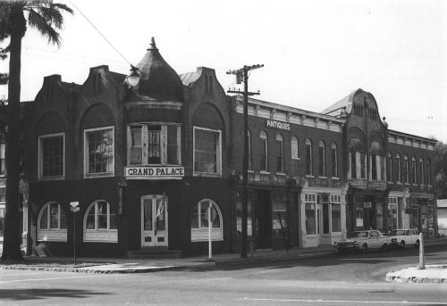
Ontario’s post office opened in 1883, and 5 of its places are on the National Register
More historic than 47% of U.S. towns · #169 of 847 in California. What drives it
5 places in town are on the National Register, among them a historic district with 9 buildings. Most of Ontario was built recently: 5% of its homes predate 1940 and the median home dates from 1980. Below: 6 old photos and papers, maps from 1888 on, and the census since 1890.
The Ontario post office opened in 1883, the earliest record of the town by name. Another post office, Zucker (1887), opened inside today’s city and later closed.
First census: 683 in 18902020 census: 175,265143 years
How historic is Ontario?
B−
More historic than 47% of U.S. towns, on its age, its old homes and the National Register.
Founding year: the first Ontario post office (Blevins & Helbock, CC0).The full story ↓
History grade
What drives Ontario’s History grade
On its age, its old homes and the National Register, Ontario is more historic than 47% of U.S. towns, #169 of 847 in California. Its National Register listings hold the grade up; its share of homes from before 1940 pulls it down.
B−
HistoryA character grade: shown, never part of Ontario’s overall grade.
Among the 400 U.S. cities of 100,000 or more, Ontario ranks #251 on History.
Few California towns list much on the Register (a typical California town has 0.0 per 10,000 residents, the U.S. 2.4), so Ontario’s 0.7 sits above most of its state (73% of California towns have fewer) while its 13 historic buildings outnumber those of 77% of U.S. towns.
How sure. Graded on any two of the three inputs instead, the letter would range from C to B. The pre-1940 share (±0.7 points) is firm at this size. The founding year is the first post office, not a stated founding date.
Founding year: the first post office (other dates in Quick answers). Homes: Census ACS 2020–24. National Register: National Park Service, May 2026 list; each listing counted once (boundary changes and added documentation belong to their listing), and a historic district counts its contributing buildings. How TownRatings grades history →
What stands out about Ontario’s past
Read from the archive, the National Register and the record. The page puts what stands out first.
Every edition of the U.S. Geological Survey’s map of Ontario. Tap a year, or press play to watch the town change.
1897Cucamonga sheet · 1:62,500
U.S. Geological Survey historical topographic maps (public domain), via Esri’s collection of the scans. The red ring marks the center of Ontario.
Places that used to be
Lost post offices, old corners, places now gone and burying grounds
Ontario’s post office has been open since 1883. Another post office, Zucker, opened and closed inside today’s town.
Ontario
1883–today
Zucker
1887–1900
Guasti
1910–today
18801950today
Hamlets and corners on the map
BallouChampagneCollinsCreeksideEtiwaGuastiRacimo
Gone or out of use
Laird ChurchchurchOntario Army Air FieldmilitaryOntario Motor SpeedwaylocaleTemple Baptist Churchchurch
1cemetery inside Ontario
Bellview
US Post Offices dataset (Blevins & Helbock, CC0). Places and cemeteries from the USGS Geographic Names Information System (2021).
Every building
Ontario, building by building, 1888–1912
Fire insurance maps drew every building, what it was made of and what it was used for, so insurers could price the risk of fire. Pick a year, then a sheet.
Ontario was inhabited by the Tongva people for over 1,000 years. Their country is now known as Tovaangar. The Ontario area was connected to the village of Cucamonga, whose location is not precisely known. The Native and Indigenous histories of Ontario are unknown and underdeveloped, but there are some digital projects.
The Spanish Empire's New Spain Portolá expedition found and named the Santa Ana River in 1769. They also explored the Cucamonga area.
In 1771, Franciscans from New Spain settled nearby, and established the Mission San Gabriel Arcángel, founding what is today San Gabriel. They enslaved the Tongva people. The area was now part of the New Spain Province of Las Californias.
Passages that mention Ontario, cut from the printed page as they were published.
A popular history of the Dominion of Canada1878 · page 595Read the page →
Read the text
Ontario. Iu the province of Ontario (Upper Canada), from the very beginning of its history, the cause of education engaged the attention of some of its most eminent scholars and public men, and was early made the subject of legislative enactment. In the year 1785, the Eev. Dr. Stewart opened a classical school at Kingston. Soon after, a garrison school was established at that place, as also at other military posts. One of the enlightened schemes of Governor Simcoe was the estab-
Text read by machine from the scan; it may contain errors.
Scans and text from the Internet Archive. Books published in 1930 or earlier, which are in the public domain.
Timeline
Ontario, 1883 to 1987
Woven from the archive, old maps, post office records, the National Register and the people born here.
Nothing in the archives for these yearsWeddings on Main Street, storms, parades, school pictures, the old store. If it’s in your family album, it belongs here.
Nothing in the archives for these yearsWeddings on Main Street, storms, parades, school pictures, the old store. If it’s in your family album, it belongs here.
The Ontario post office opened in 1883, the earliest record of the town by name (U.S. post office records).
How does Ontario rank for history?
Ontario is more historic than 47% of U.S. towns, #169 of 847 in California. The History grade combines the town’s founding era, the share of homes built before 1940 and its National Register listings. It’s a character grade, so it isn’t part of the overall grade. How it works.
What is on the National Register in Ontario?
5 listings: 4 buildings, among them the Frankish Building (listed 1980, the first), and 1 historic district, the Hofer Ranch, with 9 contributing buildings. 13 historic buildings in all.
How old are the homes in Ontario?
5% of Ontario’s homes were built before 1940 (Census estimate), against a typical 3.4% for a California town; the median home was built in 1980.
Founding dates: Wikidata, Wikipedia, the U.S. post office records of Blevins & Helbock (CC0) and the Census. Homes by year built: Census ACS 2020–24. National Register of Historic Places: National Park Service (list of May 22, 2026). Old photos, postcards and papers: Wikimedia Commons, the Library of Congress and other public archives, credited on each item’s page. Maps: U.S. Geological Survey historical topographic maps (via Esri) and Sanborn fire-insurance maps (Library of Congress). History text and census tables: Wikipedia (CC BY-SA 4.0). Places that used to be: USGS Geographic Names Information System (2021).
From Wikimedia Commons (12), the National Register of Historic Places (5), Wikipedia, Wikidata and Wikipedia for famous people, U.S. Geological Survey historical maps, U.S. Census counts (via Wikipedia), the US Post Offices dataset (Blevins & Helbock), the USGS Geographic Names Information System, Sanborn fire insurance maps (Library of Congress) and old county and town histories (Internet Archive). Archive images are copied here with their credits and licenses, shown on each photo’s page. Refreshed monthly.


 1904
 1905
 1905
 2018
 2018
 2018
 2018
 2018
 2018