Guerneville’s post office opened in 1870, and 33% of its homes were built before 1940
More historic than 80% of U.S. towns · #28 of 847 in California. What drives it
3 places in town are on the National Register, among them a historic district with 3 buildings. Below: 6 old photos and papers, maps from 1885 on, and the census since 1880.
From Guerneville’s archive · credits on each photo
Quick answers
How Guerneville began
When was Guerneville founded?
1870
The Guerneville post office opened in 1870, the earliest record of the town by name. Four smaller post offices, Vacation (1904), Eaglenest (1908) and Rio Nido (1910), opened inside today’s town and later closed.
First census: 363 in 18802020 census: 4,552156 years
How historic is Guerneville?
A−
More historic than 80% of U.S. towns, on its age, its old homes and the National Register.
Founding year: the first Guerneville post office (Blevins & Helbock, CC0).The full story ↓
History grade
What drives Guerneville’s History grade
On its age, its old homes and the National Register, Guerneville is more historic than 80% of U.S. towns, #28 of 847 in California. Its share of homes from before 1940 holds the grade up; its age pulls it down.
A−
HistoryA character grade: shown, never part of Guerneville’s overall grade.
Few California towns list much on the Register (a typical California town has 0.0 per 10,000 residents, the U.S. 2.4), so Guerneville’s 9.8 sits above most of its state (91% of California towns have fewer) while its 4 historic buildings outnumber those of 68% of U.S. towns.
How sure. Graded on any two of the three inputs instead, the letter would range from B to A. The pre-1940 share is a Census survey estimate (±5.7 points). The founding year is the first post office, not a stated founding date.
Founding year: the first post office (other dates in Quick answers). Homes: Census ACS 2020–24. National Register: National Park Service, May 2026 list; each listing counted once (boundary changes and added documentation belong to their listing), and a historic district counts its contributing buildings. How TownRatings grades history →
What stands out about Guerneville’s past
Read from the archive, the National Register and the record. The page puts what stands out first.
Lost post offices, old corners, places now gone and burying grounds
Guerneville’s post office has been open since 1870. Four other post offices opened and closed inside today’s town.
Guerneville
1870–today
Vacation
1904–1941
Eaglenest
1908–1910
Rio Nido
1910–1965
Guernewood Park
1925–1946
18701950today
Hamlets and corners on the map
El BonitaGuernewoodGuernewood ParkMonte RosaMontesanoRio NidoRolandsVacation Beach
Gone or out of use
Guernewood Park Post Officepost officeSonoma Minemine
1cemetery inside Guerneville
Redwood Memorial Gardens
US Post Offices dataset (Blevins & Helbock, CC0). Places and cemeteries from the USGS Geographic Names Information System (2021).
Every building
Guerneville, building by building, 1885–1923
Fire insurance maps drew every building, what it was made of and what it was used for, so insurers could price the risk of fire. Pick a year, then a sheet.
1885Sheet 1 of 1
Edition
Sheets
BrickWoodStone
Sanborn Map Company, via the Library of Congress. Editions published in 1930 or earlier, which are in the public domain.
Guerneville developed adjacent to the Russian River. Redwoods grew in the riverbed with such vigor that just a few centuries ago, the valley had the greatest biomass density on the planet, according to local lore. The local Pomo Indians had long used the area as a summer camp and called it "Ceola" ( or cee-oh-lay) which meant "shady place."
A large stand of ancient trees is preserved in the Fife Creek watershed, now the centerpiece of Armstrong Woods Park. But many of the trees were logged in the late 19th century and the early 20th century, giving rise to the first English name for the place – "Stumptown." Logging in the area boomed after vast amounts of lumber were needed for rebuilding after the 1906 earthquake and associated fires.
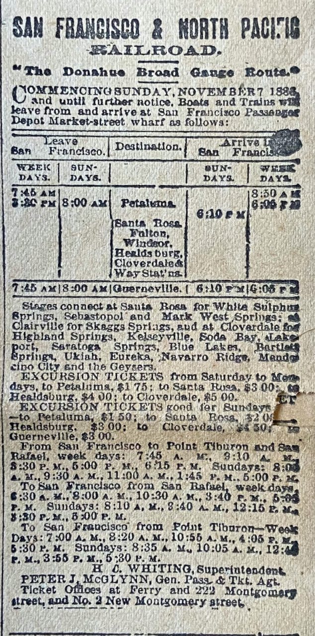
Passages that mention Guerneville, cut from the printed page as they were published.
History of Sonoma County, California, with biographical sketches of the leading men and women of the county, who have been identified with its growth and development from the early days to the present time1911 · page 1064Read the page →
Read the text
Still another of the sons of Italy who are exercising their knowledge of agriculture in Sonoma county is Angelo Dinucci, who owns a ranch of forty-five acres in close proximity to the thriving town of Guerneville, and as one of the earlier settlers of this nationality in this immediate section, he has given help and encouragement to many of his countrymen who, like himself, have come here to enjoy privileges which their own country as yet has no conception of.
Text read by machine from the scan; it may contain errors.
Scans and text from the Internet Archive. Books published in 1930 or earlier, which are in the public domain.
Timeline
Guerneville, 1870 to 1947
Woven from the archive, old maps, post office records, the National Register and the people born here.
Nothing in the archives for these yearsWeddings on Main Street, storms, parades, school pictures, the old store. If it’s in your family album, it belongs here.
The Guerneville post office opened in 1870, the earliest record of the town by name (U.S. post office records).
How does Guerneville rank for history?
Guerneville is more historic than 80% of U.S. towns, #28 of 847 in California. The History grade combines the town’s founding era, the share of homes built before 1940 and its National Register listings. It’s a character grade, so it isn’t part of the overall grade. How it works.
What is on the National Register in Guerneville?
Three places: the Guerneville Bridge (listed 1989), the Pond Farm Pottery Historic District (2014) and the Belden-Birkhofer House (2024).
How old are the homes in Guerneville?
33% of Guerneville’s homes were built before 1940 (Census estimate, ±5.7 points), against a typical 3.4% for a California town; the median home was built in 1955.
Founding dates: Wikidata, Wikipedia, the U.S. post office records of Blevins & Helbock (CC0) and the Census. Homes by year built: Census ACS 2020–24. National Register of Historic Places: National Park Service (list of May 22, 2026). Old photos, postcards and papers: Wikimedia Commons, the Library of Congress and other public archives, credited on each item’s page. Maps: U.S. Geological Survey historical topographic maps (via Esri) and Sanborn fire-insurance maps (Library of Congress). History text and census tables: Wikipedia (CC BY-SA 4.0). Places that used to be: USGS Geographic Names Information System (2021).
From Wikimedia Commons (2), the Library of Congress (5), the National Register of Historic Places (3), Wikipedia, U.S. Geological Survey historical maps, U.S. Census counts (via Wikipedia), the US Post Offices dataset (Blevins & Helbock), the USGS Geographic Names Information System, Sanborn fire insurance maps (Library of Congress) and old county and town histories (Internet Archive). Archive images are copied here with their credits and licenses, shown on each photo’s page. Refreshed monthly.




 1909
 1909
 1909
 Date?
 2023