East NilesCA
A town of 28,532.
Is East Niles a good place to live?
East Niles grades D− overall, ranked 813th of 841 in California, mostly because of health and incomes. Residents are less healthy than 94% of U.S. towns on CDC estimates. The median household income is $55K, and 29% of residents live below the poverty line. What it does well: it is easier to get around on foot or by transit than 70% of U.S. towns. 29% of residents live below the poverty line in East Niles, where California’s towns sit at 10% and U.S. towns at 9.6%. Only 88 of California’s 1,064 towns score lower on the outdoors.
94% of working residents leave East Niles for work
Where East Niles’s working residents go each day. Line width shows the share.
Census LEHD 2023
How East Niles grades
Each subject compared with towns across the country (schools within California), ordered by how far East Niles is from typical.
How TownRatings grades towns →
Moving to East Niles: who provides what
East Niles is unincorporated, so Kern County and regional agencies provide most services.
EPA SDWIS (Oct 9, 2026) · HIFLD + EIA-861 2025 · Census 2020 ZCTAs · NCES 2024–25 · registration: vote.gov, updated Nov 18, 2024.
The data
Ordered by what stands out in East Niles.
East Niles has more 90° days than nearly all U.S. towns, but it has poverty well above the California rate and has little public open land.
East Niles earns a D for health
37% of adults say their health is fair or poor in East Niles. East Niles beats the California average on 1 of 32 CDC measures and trails it on 23. 22% of adults report frequent mental distress in East Niles.
| East Niles | California towns | U.S. towns | |
|---|---|---|---|
| Fair or poor health (CDC PLACES) | 37% | 22% | 19% |
| Frequent mental distress (CDC PLACES) | 22% | 17% | 17% |
| Frequent physical distress (CDC PLACES) | 19% | 14% | 14% |
| Get no exercise (CDC PLACES) | 40% | 24% | 25% |
| What stands out | East Niles | CA |
|---|---|---|
| Fewer adults who have had cancer | 4.7% | 6.4% |
| More uninsured adults | 25.4% | 10.6% |
CDC PLACES 2025 · modeled estimates for adults · CMS · HRSA
Public schools in East Niles fall behind 77% of California districts
Two of its 6 schools are below, each with why it’s listed. The largest public high school is Foothill High, with 2,043 students.
| School | Level | Students | Letter |
|---|---|---|---|
| Voorhies ElementaryLargest public elementary schoolGrades K–6 | Grades K–6 | 915 | – |
| Foothill HighLargest public high schoolGrades 9–12 | Grades 9–12 | 2,043 | A |
NCES · EDFacts · graded within CA on state tests and graduation
Most of East Niles’ workers commute out: the town has 0.4 jobs for each of them
Most working residents leave East Niles for work: only 6% work in town. 3.5% of East Niles workers work from home. Since 2013, East Niles has added 515 jobs, to 4,279 in 2023.
| East Niles | California towns | U.S. towns | |
|---|---|---|---|
| Work from home | 3.5% | 14% | 11% |
| Median household income | $55,000 | $95,000 | $80,000 |
| Average trip to work | 25 minutes | 28 minutes | 25 minutes |
| Working residents who work in town | 5.6% | 6.6% | 8% |
Where working residents work
Census LEHD 2023 · ACS
East Niles has mild winters and hot summers
The Bakersfield Ap weather station, 9 miles away, records that about 112 days a year reach 90°, more than in 97% of U.S. towns. July afternoons average 99.5°, hotter than in 99% of U.S. towns; January nights average 39.9°.
East Niles has mild winters and hot summers, with very little rain. East Niles’ July high is 100°F. Snow is almost unheard of.
| East Niles | California towns | U.S. towns | |
|---|---|---|---|
| July high | 100°F | 89°F | 85°F |
| January low | 40°F | 41°F | 22°F |
Typical low → high °F
NOAA U.S. Climate Normals, 1991–2020
East Niles faces a high natural-hazard risk, led by earthquakes
Expected storm and flood damage is higher than in 67% of U.S. communities.
FEMA National Risk Index · OpenFEMA
East Niles has set aside 0.4% of its land for conservation
Just 13 of its 3,478 acres are conserved, so there is little public open land in East Niles itself; its outdoors grade is D.
0.5 miles of trail in 1 park or preserve. The trail density in East Niles is 0.1 miles per square mile.
| East Niles | California towns | U.S. towns | |
|---|---|---|---|
| Miles of trail per square mile | 0.1 miles per square mile | 1.0 | 0.4 |
| Conserved land | 0.4% | 4.3% | 4.3% |
| Biggest places to walk | Trails | Acres |
|---|---|---|
| 1. Pioneer Park | 0.5 mi | 10 |
Trails & parks © OpenStreetMap contributors · Conserved land: USGS PAD-US
The median home in East Niles sells for about $325K
69.5% of renter households pay 30% or more of their income for housing, against 55.3% across California. The median property tax bill is $2,287, against $5,124 across California, another input to its cost-of-living grade.
Zillow Home Value Index · Redfin Data Center
Dignity Health Arena and 7 more within 40 miles
Museums, parks, gardens and other places to visit around East Niles. Close and well known come first.
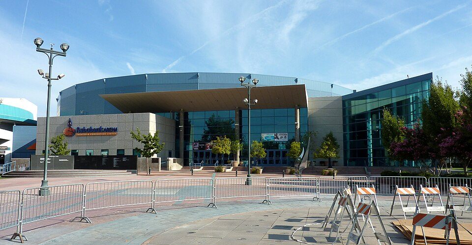 5 mi Stadium & arenaDignity Health Arena
 34 mi MuseumFort Tejon
 22 mi National MonumentCésar E. Chávez National Monument31K visitors a year
 6 mi MuseumKern County Museum85K visitors a year5 mi Zoo & aquariumCalifornia Living Museum
 5 mi MuseumBakersfield Museum of Art
Photo credits
Dignity Health Arena: Bobak Ha'Eri, CC BY 3.0 · Fort Tejon: Yellowute at English Wikipedia, Public domain · César E. Chávez National Monument: Bobak Ha'Eri, CC BY 3.0 · Kern County Museum: (WT-de) Mistoffeles, CC BY-SA 4.0 · Bakersfield Museum of Art: Skyman9999. Skyman9999, CC0


Everything we know about East Niles
Colleges nearby
3 within 15 miles of the center of East Niles
About 6 of every 100 East Niles residents are enrolled in college, against 8 across California.
About East Niles
Census-designated place near Bakersfield, US
East Niles is an unincorporated community and census-designated place (CDP) in Kern County, California. As of the 2020 census, East Niles had a population of 28,390. The CDP is within the Bakersfield's census county division, and borders the city of Bakersfield to the north and the southwest, Bakersfield Country Club to the northwest, Hillcrest and Potomac Park to the west, and Fairfax to the south.
From Wikipedia, licensed CC BY-SA 4.0 · facts via Wikidata (CC0)
East Niles’s neighbors
2 towns share a border with East Niles.
| Town | CA rank | Overall | Cost | Safety | Schools | Health |
|---|---|---|---|---|---|---|
| East Niles | #813 | D− | C− | — | C− | D |
| Bakersfield | #780 | D− | D− | D | C | C |
| Bakersfield Country Club | — | — | D | — | C− | B+ |
Bakersfield Country Club has fewer than 2,500 residents, so it gets subject grades but no overall grade. East Niles and Bakersfield Country Club report no FBI crime data of their own. Compare East Niles with a neighbor →
Questions about East Niles
Short answers, built from the data on this page.
Is East Niles, CA a good place to live?
East Niles grades D− overall, in the bottom 2% of U.S. towns and #813 of 841 in California. It grades D for health and C− for schools. Health is its weak spot, with a D.
Is East Niles, CA expensive?
Yes. The typical home is worth about $252,000, 67% below the California typical home. Cost of living, which also weighs rents, property taxes and how many households pay 30% or more of their income for housing, grades C−.