
112 years in pictures
Census counts: 4,042 in 1940, 19,495 in 2020. The archive holds 6 old photos and papers going back to 1936 and 4 maps from 1930 on.
- 1914Arvin is settled
Each edition grades its towns against each other only.

Arvin grades D− overall, 824th of 841 graded towns in California, mostly because of health and incomes. CDC estimates put its residents' health behind 96% of the country. The median household income is $49K, and 35% of residents live below the poverty line. One bright spot: it is easier to get around on foot or by transit than 51% of U.S. towns. 35% of residents live below the poverty line in Arvin, where California’s towns sit at 10% and U.S. towns at 9.6%. Arvin's civic life (library use, community groups, volunteering) trails 100% of U.S. towns. FEMA rates its natural-hazard risk higher than 95% of U.S. communities, with inland flooding at the top.
Where Arvin’s working residents go each day. Line width shows the share.
Census LEHD 2023
Each subject compared with towns across the country (schools within California), ordered by how far Arvin is from typical.
How TownRatings grades towns →

Census counts: 4,042 in 1940, 19,495 in 2020. The archive holds 6 old photos and papers going back to 1936 and 4 maps from 1930 on.
Who provides power, water and the rest in Arvin, and how to reach them.
EPA SDWIS (Oct 9, 2026) · HIFLD + EIA-861 2025 · Census 2020 ZCTAs · NCES 2024–25 · registration: vote.gov, updated Nov 18, 2024.
Ordered by what stands out in Arvin.
Arvin has more 90° days than nearly all U.S. towns and has property taxes about half the California norm, but it has poverty well above the California rate.
41% of Arvin adults say their health is fair or poor. Arvin beats the California average on 1 of 32 CDC measures and trails it on 24. 23% of Arvin adults report frequent mental distress.
| Arvin | California towns | U.S. towns | |
|---|---|---|---|
| Fair or poor health (CDC PLACES) | 41% | 22% | 19% |
| Frequent mental distress (CDC PLACES) | 23% | 17% | 17% |
| Frequent physical distress (CDC PLACES) | 20% | 14% | 14% |
| Get no exercise (CDC PLACES) | 44% | 24% | 25% |
| What stands out | Arvin | CA |
|---|---|---|
| Fewer adults who have had cancer | 3.4% | 6.4% |
| More uninsured adults | 32.2% | 10.6% |
CDC PLACES 2025 · modeled estimates for adults · CMS · HRSA
Its public schools are run by the Arvin Union school district. Two of its 6 schools are below, each with why it’s listed. The largest public high school is Arvin High, with 2,653 students.
| School | Level | Students | Letter |
|---|---|---|---|
| El Camino Real ElementaryLargest public elementary schoolGrades K–6 | Grades K–6 | 771 | – |
| Arvin HighLargest public high schoolGrades 9–12 | Grades 9–12 | 2,653 | A+ |
NCES · EDFacts · graded within CA on state tests and graduation
The median property tax bill is $2,461, against $5,124 across California, another input to its cost-of-living grade.
The typical Arvin home is worth about $301,000, up 0.8% in a year, 61% below the California typical home. Arvin’s median rent is $1,122 a month.
| Arvin | California towns | U.S. towns | |
|---|---|---|---|
| Households that own their home | 54% | 64% | 73% |
| Median rent | $1,122 a month | $1,898 a month | $1,185 a month |
Census ACS, 2020–24 · Zillow Home Value Index · Redfin Data Center
Since 1998, 3 flood insurance claims have been paid out in Arvin.
FEMA flood insurance claims · FEMA National Risk Index · OpenFEMA
Most working residents leave Arvin for work: only 11% work in town. Since 2013, Arvin has added 360 jobs, to 2,130 in 2023. The average trip to work in Arvin is 25 minutes.
| Arvin | California towns | U.S. towns | |
|---|---|---|---|
| Median household income | $49,000 | $95,000 | $80,000 |
| Average trip to work | 25 minutes | 28 minutes | 25 minutes |
| Working residents who work in town | 11% | 6.6% | 8% |
Census LEHD 2023 · ACS
The Bakersfield Ap weather station, 21 miles away, records that about 112 days a year reach 90°, more than in 97% of U.S. towns. July afternoons average 99.1°, hotter than in 99% of U.S. towns; January nights average 39.9°.
Arvin has mild winters and hot summers, with very little rain. Snow is almost unheard of.
| Arvin | California towns | U.S. towns | |
|---|---|---|---|
| July high | 99°F | 89°F | 85°F |
| January low | 40°F | 41°F | 22°F |
NOAA U.S. Climate Normals, 1991–2020
| Arvin | California towns | U.S. towns | |
|---|---|---|---|
| Miles of trail per square mile | 0.2 miles per square mile | 1.0 | 0.4 |
| Conserved land | 1.6% | 4.3% | 4.3% |
| Biggest places to walk | Trails | Acres |
|---|---|---|
| 1. Smothermon Park | 0.5 mi | 19 |
| 2. Di Giorgio County Park | 0.3 mi | 17 |
| 3. Kovacevich Park | 0.1 mi | 5 |
Trails & parks © OpenStreetMap contributors · Conserved land: USGS PAD-US
Museums, parks, gardens and other places to visit around Arvin. Close and well known come first.
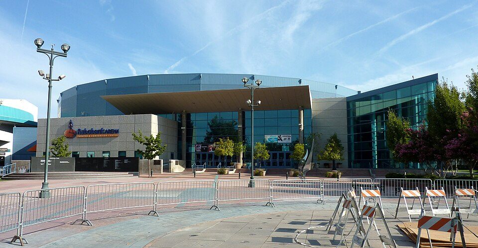
16 mi Stadium & arenaDignity Health Arena
22 mi MuseumFort Tejon
15 mi National MonumentCésar E. Chávez National Monument31K visitors a year
17 mi MuseumKern County Museum85K visitors a year17 mi Zoo & aquariumCalifornia Living Museum
28 mi MuseumESMoADignity Health Arena: Bobak Ha'Eri, CC BY 3.0 · Fort Tejon: Yellowute at English Wikipedia, Public domain · César E. Chávez National Monument: Bobak Ha'Eri, CC BY 3.0 · Kern County Museum: (WT-de) Mistoffeles, CC BY-SA 4.0 · ESMoA: Teamone Esmoa, CC BY-SA 3.0
None within 15 miles of Arvin; the nearest are
About 7 of every 100 Arvin residents are enrolled in college, about the same as California.
City in California, United States
Arvin is a city in Kern County, California, United States. Arvin is located 15 miles (24 km) southeast of Bakersfield, at an elevation of 449 feet (137 m). As of the 2020 census, the population was 19,495, up from 19,304 at the 2010 census. In 2007, the United States Environmental Protection Agency (EPA) listed Arvin as having the highest levels of smog of any community in the United States. The city's level of ozone, smog's primary component, exceeded the EPA's acceptable limits on an average of 73 days per year between 2004 and 2006. Wired telephone numbers in Arvin follow the format (661) 854-xxxx or (661) 855-xxxx and the ZIP Code is 93203.
From Wikipedia, licensed CC BY-SA 4.0 · facts via Wikidata (CC0)
Short answers, built from the data on this page.
Arvin grades D− overall, in the bottom 2% of U.S. towns and #824 of 841 in California. It grades D− for health and C+ for schools. Hazard risk is its weak spot, with a D−.
Yes. That is 4.3 years of the area's median household income ($70,210 across the Bakersfield-Delano, CA metro area). Cost of living, which also weighs rents, property taxes and how many households pay 30% or more of their income for housing, grades C−.