Most of Spanish Fort was built recently: 0.0% of its homes predate 1940 and the median home dates from 1999. Below: 1 old photo or paper, maps from 1921 on, and the census since 1970.
On its age, its old homes and the National Register, Spanish Fort is among the newest of U.S. towns. Its National Register listings hold the grade up; its age pulls it down.
D−
HistoryA character grade: shown, never part of Spanish Fort’s overall grade.
Alabama towns list about as much on the Register as the country (a typical Alabama town has 2.7 per 10,000 residents, the U.S. 2.4), so Spanish Fort’s 0.0 sits below most of its state (26% of Alabama towns have fewer) while its 0 listings outnumber those of 23% of U.S. towns.
How sure. Graded on any two of the three inputs instead, the letter would still be D−. The pre-1940 share (±0.4 points) is firm at this size.
Founding year: the first census (other dates in Quick answers). Homes: Census ACS 2020–24. National Register: National Park Service, May 2026 list; each listing counted once (boundary changes and added documentation belong to their listing), and a historic district counts its contributing buildings. How TownRatings grades history →
What stands out about Spanish Fort’s past
Read from the archive, the National Register and the record. The page puts what stands out first.
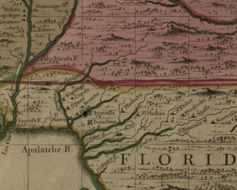
The city of Spanish Fort is rich in history dating as far back as 1702 with the founding of Mobile by Jean-Baptiste Le Moyne de Bienville of France. Spanish Fort was originally the site of a trading post established by French-occupied Mobile. One of the earliest known colonists that settled in present-day Spanish Fort was Louis Augustin Rochon, son of co-founder of Mobile Charles Rochon. Around 1750-1760, the younger Rochon founded a plantation on the bluffs overlooking the Blakeley River that became relatively wealthy. Following the French and Indian War, a large area on the Gulf Coast including the trading post was ceded to the British in 1763. During the Revolutionary War, Spanish forces under Bernardo de Gálvez took Mobile in the Battle of Fort Charlotte. Consequentially, the entire Mobile Bay area came under military administration, albeit challenged by British forces based in Pens…
The Spanish Fort post office opened in 1970, the earliest record of the town by name (U.S. post office records). Wikidata gives 1712.
How does Spanish Fort rank for history?
Spanish Fort is among the newest of U.S. towns. The History grade combines the town’s founding era, the share of homes built before 1940 and its National Register listings. It’s a character grade, so it isn’t part of the overall grade. How it works.
How old are the homes in Spanish Fort?
0.0% of Spanish Fort’s homes were built before 1940 (Census estimate), against a typical 3.2% for an Alabama town; the median home was built in 1999.
Founding dates: Wikidata, Wikipedia, the U.S. post office records of Blevins & Helbock (CC0) and the Census. Homes by year built: Census ACS 2020–24. National Register of Historic Places: National Park Service (list of May 22, 2026). Old photos, postcards and papers: Wikimedia Commons, the Library of Congress and other public archives, credited on each item’s page. Maps: U.S. Geological Survey historical topographic maps (via Esri) and Sanborn fire-insurance maps (Library of Congress). History text and census tables: Wikipedia (CC BY-SA 4.0). Places that used to be: USGS Geographic Names Information System (2021).
From Wikimedia Commons (6), the Library of Congress (16), Wikipedia, Wikidata and Wikipedia for famous people, U.S. Geological Survey historical maps, U.S. Census counts (via Wikipedia) and the USGS Geographic Names Information System. Archive images are copied here with their credits and licenses, shown on each photo’s page. Refreshed monthly.



 2015
 2015
 2015
 2015
 2013
 2010
 2010
 2010
 2010
 2010
 2010
 2010
 2010
 2010
 2010
 2010
 2010
 2010
 2010
 2010
 2010