Laramie dates to 1868, and 17% of its homes were built before 1940
More historic than 76% of U.S. towns · #3 of 28 in Wyoming. What drives it
20 places in town are on the National Register, among them six historic districts with 849 buildings between them. Below: 16 old photos and papers, maps from 1883 on, and the census since 1870.
On its age, its old homes and the National Register, Laramie is more historic than 76% of U.S. towns, #3 of 28 in Wyoming. Its National Register listings hold the grade up; its age pulls it down.
A−
HistoryA character grade: shown, never part of Laramie’s overall grade.
Wyoming towns list more on the Register than most of the country (a typical Wyoming town has 25.1 per 10,000 residents, the U.S. 2.4), so Laramie’s 269 sits above most of its state (96% of Wyoming towns have fewer) while its 866 historic buildings outnumber those of 98% of U.S. towns.
How sure. Graded on any two of the three inputs instead, the letter would range from B− to A. The pre-1940 share (±2.2 points) is firm at this size. Two sources give 1868.
Founding year: Wikidata (other dates in Quick answers). Homes: Census ACS 2020–24. National Register: National Park Service, May 2026 list; each listing counted once (boundary changes and added documentation belong to their listing), and a historic district counts its contributing buildings. How TownRatings grades history →
What stands out about Laramie’s past
Read from the archive, the National Register and the record. The page puts what stands out first.
National Park Service, National Register of Historic Places. Photos from Wikimedia Commons, credited on each place’s page.
Every building
Laramie, building by building, 1883–1924
Fire insurance maps drew every building, what it was made of and what it was used for, so insurers could price the risk of fire. Pick a year, then a sheet.
Sanborn Map Company, via the Library of Congress. Editions published in 1930 or earlier, which are in the public domain.
The story so far
Laramie, in brief
Wikipedia doesn’t have a history of Laramie yet. The photos, dates and memories neighbors add here are how it gets written.
Laramie () is a city in and the county seat of Albany County, Wyoming, United States, known for its high elevation at 7,200 feet (2,200 m), for its railroad history, and as the home of the University of Wyoming. The population was 31,407 at the 2020 census, making it the fourth-most populous city in Wyoming. Located on the Laramie River, the city is west of Cheyenne and 25 miles (40 km) north of the Colorado state line, at the junction of Interstate 80 and U.S. Route 287. After 12,000 years or more of Indigenous populations living in the area, Laramie was settled by European Americans in 1868 with the completion of the Union Pacific Railroad line to the area, which crosses the Laramie River…
Laramie was established in 1868. Its population held steady between the last two censuses: 30,816 in 2010, 31,407 in 2020.
Intro from Wikipedia. Population: U.S. Census Bureau.
From the old history books
What they wrote about Laramie in 1875
Passages that mention Laramie, cut from the printed page as they were published.
History and directory of Laramie City, Wyoming Territory1875 · page 35Read the page →
Read the text
Water Supply. — It would be improper to omit some account of the means for water supply. The water, which is taken from a distant spring, is conveyed from the spring a distance of 12,728 feet through twelve inch pipe, into the town of Laramie City. This pipe has on it one eight inch branch, one six inch branch, and sixteen four inch branches. These branches are short, merely sufficient to permit the citizens of Laramie — for whose benefit so large a pipe was laid— tOv connect lines of water pipe, for town and domestic purposes, with thosQ-
Text read by machine from the scan; it may contain errors.
History and directory of Laramie City, Wyoming Territory1875 · page 51Read the page →
Read the text
Through the Laramie Plains run four beautiful streams, viz: the Big and Little Laramie rivers. Rock Creek, and Medicine Bow Creek, all of them streams large enough to float ties, timber, lumber, and fencing material irom immense forests of pine and spruce which cover the entire mountain region west of us. And while we were for a time eclipsed by the great work of our government in the construction of our national highway, the Union Pacific railroad, for the development of this country, we need but look for a moment at nature's own provision in
Text read by machine from the scan; it may contain errors.
Scans and text from the Internet Archive. Books published in 1930 or earlier, which are in the public domain.
Timeline
Laramie, 1860 to 1983
Woven from the archive, old maps, post office records, the National Register and the people born here.
Nothing in the archives for these yearsWeddings on Main Street, storms, parades, school pictures, the old store. If it’s in your family album, it belongs here.
In 1868, according to Wikidata. Laramie’s post office opened in 1888, and the census of 1870 counted 828 people here.
How does Laramie rank for history?
Laramie is more historic than 76% of U.S. towns, #3 of 28 in Wyoming. The History grade combines the town’s founding era, the share of homes built before 1940 and its National Register listings. It’s a character grade, so it isn’t part of the overall grade. How it works.
What is on the National Register in Laramie?
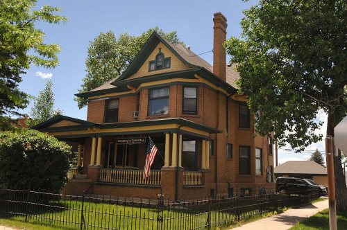
20 listings: 14 buildings, among them the Ivinson Mansion and Grounds (listed 1972, the first), and 6 historic districts with 849 contributing buildings. 866 historic buildings in all.
How old are the homes in Laramie?
17% of Laramie’s homes were built before 1940 (Census estimate, ±2.2 points), against a typical 12% for a Wyoming town; the median home was built in 1977.
Founding dates: Wikidata, Wikipedia, the U.S. post office records of Blevins & Helbock (CC0) and the Census. Homes by year built: Census ACS 2020–24. National Register of Historic Places: National Park Service (list of May 22, 2026). Old photos, postcards and papers: Wikimedia Commons, the Library of Congress and other public archives, credited on each item’s page. Maps: U.S. Geological Survey historical topographic maps (via Esri) and Sanborn fire-insurance maps (Library of Congress). History text and census tables: Wikipedia (CC BY-SA 4.0). Places that used to be: USGS Geographic Names Information System (2021).
From Wikimedia Commons (12), the Library of Congress (4), Wikidata (2), the National Register of Historic Places (20), Wikidata and Wikipedia for famous people, U.S. Geological Survey historical maps, U.S. Census counts (via Wikipedia), the US Post Offices dataset (Blevins & Helbock), the USGS Geographic Names Information System, Sanborn fire insurance maps (Library of Congress) and old county and town histories (Internet Archive). Archive images are copied here with their credits and licenses, shown on each photo’s page. Refreshed monthly.




 c. 1864
 c. 1865
 c. 1865
 c. 1865
 c. 1865
 1868
 c. 1908
 1940
 1940
 1940
 1940


