Wheeling dates to 1769, and 41% of its homes were built before 1940
Among the most historic 1% of U.S. towns · #1 of 61 in West Virginia. What drives it
46 places in town are on the National Register, among them 2 National Historic Landmarks and ten historic districts with 4,710 buildings between them. Below: 9 old photos and papers, maps from 1884 on, and the census since 1840.
Founding year: Wikidata; Wikipedia’s history section gives the same year. First post office: 1794.The full story ↓
History grade
What drives Wheeling’s History grade
On its age, its old homes and the National Register, Wheeling is among the most historic 1% of U.S. towns, #1 of 61 in West Virginia. All 3 inputs put Wheeling near the top nationally; its National Register listings ranks highest.
A+
HistoryA character grade: shown, never part of Wheeling’s overall grade.
West Virginia towns list more on the Register than most of the country (a typical West Virginia town has 29.6 per 10,000 residents, the U.S. 2.4), so Wheeling’s 1,801 sits above most of its state (98% of West Virginia towns have fewer) while its 4,745 historic buildings outnumber those of 100% of U.S. towns.
How sure. Graded on any two of the three inputs instead, the letter would still be A+. The pre-1940 share (±2.9 points) is firm at this size. Two sources give 1769.
Founding year: Wikidata (other dates in Quick answers). Homes: Census ACS 2020–24. National Register: National Park Service, May 2026 list; each listing counted once (boundary changes and added documentation belong to their listing), and a historic district counts its contributing buildings. How TownRatings grades history →
What stands out about Wheeling’s past
Read from the archive, the National Register and the record. The page puts what stands out first.
The country’s official list of buildings and places worth saving. 2 are National Historic Landmarks, the highest tier. Boundary changes and added documentation are counted with their listing.
National Park Service, National Register of Historic Places. Photos from Wikimedia Commons, credited on each place’s page.
Places that used to be
Lost post offices, old corners, places now gone and burying grounds
Wheeling’s post office has been open since 1794. Six other post offices opened and closed inside today’s town.
Wheeling
1794–today
Elm Grove
1833–1915
Greggsville
1867–1879
Greggs
1890–1907
Whitfield
1890–1904
Glenova
1905–1910
Warwood
1910–1914
17901910today
Hamlets and corners on the map
East WheelingEcho PointEdgewoodElm GroveElm TerraceForest HillsFultonGlenns RunGlenwoodGreggsvilleHawthorne CourtLeatherwoodLeewood ParkMill AcresMount de ChantalMozartNorth IslandNorth ParkNorth WheelingOakmontOakmont HillsParkviewPleasant ValleySouth Island
Gone or out of use
Central High SchoolschoolClay SchoolschoolEdgington Lane Public SchoolschoolFrank Hoffman GardenlocaleFulton Public SchoolschoolGreggsville Public SchoolschoolJ D Merriman GardenlocaleJefferson Special SchoolschoolJohn C Tucker GardenlocaleKruger Street SchoolschoolLincoln SchoolschoolLock 12damMcKinley Vocational High SchoolschoolMount de Chantal AcademyschoolNorth Park Primary SchoolschoolOhio County JailbuildingOld Stone Presbyterian ChurchchurchPark View Elementary Schoolschool
7cemeteries and burying grounds inside Wheeling
GreenwoodGreggMount CalvaryMount WoodOaklawn Memorial ParkPeninsularStone Church
US Post Offices dataset (Blevins & Helbock, CC0). Places and cemeteries from the USGS Geographic Names Information System (2021).
The origins of the name "Wheeling" are disputed. One of the more credible explanations is that the word comes from the Lenni-Lenape phrase wih link or wee lunk, which meant "place of the head" or "place of the skull." This name supposedly referred to a white settler who was scalped and decapitated. His severed head was displayed at the confluence of Wheeling Creek and the Ohio River. Earlier sources say that the head was that of a Native American prisoner, not a settler. Native Americans had inhabited the area for thousands of years. In the 17th century, the Iroquois from present-day New York state conquered the upper Ohio Valley, pushing out other tribes and maintaining the area as their hunting ground.
Passages that mention Wheeling, cut from the printed page as they were published.
Rambles in the path of the steam-horse. An off-hand olla podrida, embracing a general historical and descriptive view of the scenery, agricultural and mineral resources, and prominent features of the travelled route from Baltimore to Harper's Ferry, Cumbe1855 · page 362Read the page →
Read the text
Wheeling will, in a very short time, be connected by railroad with the cities of Cleveland and Sandusky, on Lake Erie, and thence with all the numex'ous railroads radiating from those points, as well as several intermediate tributary ones. The road from Cleveland to Wellsville, on the Ohio river, is already completed and equipped with running machinery ; while that from Wellsville to Wheeling, only forty miles in length, is being actively prosecuted. By the Cincinnati and Zanesville road, she has a straiglit line connection with Cincinnati, as well as
Text read by machine from the scan; it may contain errors.
Rambles in the path of the steam-horse. An off-hand olla podrida, embracing a general historical and descriptive view of the scenery, agricultural and mineral resources, and prominent features of the travelled route from Baltimore to Harper's Ferry, Cumbe1855 · page 86Read the page →
Read the text
The same general reasoning will apply to Parkersburg. For the convenience and accommodation of the southern trade of Ohio and the States south of her, a terminus at the city of Wheeling would have held out no temptation. Wheeling could not have controlled it. It would have sought its market at some more practicable and convenient point.
Text read by machine from the scan; it may contain errors.
Scans and text from the Internet Archive. Books published in 1930 or earlier, which are in the public domain.
Timeline
Wheeling, 1769 to 1961
Woven from the archive, old maps, post office records, the National Register and the people born here.
Every edition of the U.S. Geological Survey’s map of Wheeling. Tap a year, or press play to watch the town change.
1902Wheeling sheet · 1:62,500
U.S. Geological Survey historical topographic maps (public domain), via Esri’s collection of the scans. The red ring marks the center of Wheeling.
Every building
Wheeling, building by building, 1884–1922
Fire insurance maps drew every building, what it was made of and what it was used for, so insurers could price the risk of fire. Pick a year, then a sheet.
In 1769, according to Wikidata and Wikipedia’s history of the town. Wheeling’s post office opened in 1794, and the census of 1840 counted 7,885 people here.
How does Wheeling rank for history?
Wheeling is among the most historic 1% of U.S. towns, #1 of 61 in West Virginia. The History grade combines the town’s founding era, the share of homes built before 1940 and its National Register listings. It’s a character grade, so it isn’t part of the overall grade. How it works.
What is on the National Register in Wheeling?
46 listings, 2 of them National Historic Landmarks: 26 buildings, among them the West Virginia Independence Hall (a National Historic Landmark since 1988), 19 historic districts with 4,710 contributing buildings, and 2 structures. 4,745 historic buildings in all.
How old are the homes in Wheeling?
41% of Wheeling’s homes were built before 1940 (Census estimate, ±2.9 points), against a typical 13% for a West Virginia town; the median home was built in 1949.
Founding dates: Wikidata, Wikipedia, the U.S. post office records of Blevins & Helbock (CC0) and the Census. Homes by year built: Census ACS 2020–24. National Register of Historic Places: National Park Service (list of May 22, 2026). Old photos, postcards and papers: Wikimedia Commons, the Library of Congress and other public archives, credited on each item’s page. Maps: U.S. Geological Survey historical topographic maps (via Esri) and Sanborn fire-insurance maps (Library of Congress). History text and census tables: Wikipedia (CC BY-SA 4.0). Places that used to be: USGS Geographic Names Information System (2021).
From Wikimedia Commons (9), Wikidata (3), the National Register of Historic Places (47), Wikipedia, Wikidata and Wikipedia for famous people, U.S. Geological Survey historical maps, U.S. Census counts (via Wikipedia), the US Post Offices dataset (Blevins & Helbock), the USGS Geographic Names Information System, Sanborn fire insurance maps (Library of Congress) and old county and town histories (Internet Archive). Archive images are copied here with their credits and licenses, shown on each photo’s page. Refreshed monthly.


 ★ Landmark
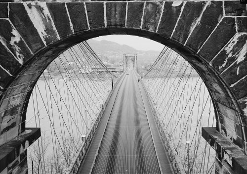 ★ Landmark


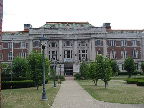


 1859
 1859
 1859
 1859
 1859
 1859
 1862


