Weston dates to 1818, and 38% of its homes were built before 1940
More historic than 97% of U.S. towns · #4 of 61 in West Virginia. What drives it
6 places in town are on the National Register, among them the Weston State Hospital, a National Historic Landmark, and two historic districts with 251 buildings between them. Below: 11 old photos and papers, maps from 1894 on, and the census since 1860.
Founding year: Wikidata; Wikipedia’s history section gives the same year. First post office: 1818.The full story ↓
History grade
What drives Weston’s History grade
On its age, its old homes and the National Register, Weston is more historic than 97% of U.S. towns, #4 of 61 in West Virginia. All 3 inputs are above most U.S. towns; its share of homes from before 1940 ranks highest and its age lowest.
A+
HistoryA character grade: shown, never part of Weston’s overall grade.
West Virginia towns list more on the Register than most of the country (a typical West Virginia town has 29.6 per 10,000 residents, the U.S. 2.4), so Weston’s 661 sits above most of its state (87% of West Virginia towns have fewer) while its 254 historic buildings outnumber those of 94% of U.S. towns.
How sure. Graded on any two of the three inputs instead, the letter would range from A to A+. The pre-1940 share is a Census survey estimate (±6.8 points). Two sources give 1818.
Founding year: Wikidata (other dates in Quick answers). Homes: Census ACS 2020–24. National Register: National Park Service, May 2026 list; each listing counted once (boundary changes and added documentation belong to their listing), and a historic district counts its contributing buildings. How TownRatings grades history →
What stands out about Weston’s past
Read from the archive, the National Register and the record. The page puts what stands out first.
The country’s official list of buildings and places worth saving. One is a National Historic Landmark, the highest tier. Boundary changes and added documentation are counted with their listing.
National Park Service, National Register of Historic Places. Photos from Wikimedia Commons, credited on each place’s page.
Places that used to be
Lost post offices, old corners, places now gone and burying grounds
Weston’s post office has been open since 1820. Another post office, Preston, opened and closed inside today’s town.
Preston
1818–1820
Weston
1820–today
18101920today
Hamlets and corners on the map
Buck HillCox TownDonlan HeightsHalevilleKitsonvilleMcGaryShady BrookSmith Village
Gone or out of use
City HospitalhospitalFirst Methodist Episcopal ChurchchurchHaleville SchoolschoolKitsonville Public SchoolschoolOutreach Christian SchoolschoolPolk Creek Elementary SchoolschoolShadybrook Primary CenterschoolWeston Central Elementary SchoolschoolWeston Colored SchoolschoolWeston General HospitalhospitalWeston High SchoolschoolWeston State HospitalhospitalWeston United Brethren Churchchurch
2cemeteries and burying grounds inside Weston
MachperlahOld Hill
US Post Offices dataset (Blevins & Helbock, CC0). Places and cemeteries from the USGS Geographic Names Information System (2021).
Every building
Weston, building by building, 1894–1921
Fire insurance maps drew every building, what it was made of and what it was used for, so insurers could price the risk of fire. Pick a year, then a sheet.
Weston was founded in 1818 as Preston; the name was changed to Fleshersville soon after, and then to Weston in 1819. The city was incorporated in 1846.
Passages that mention Weston, cut from the printed page as they were published.
A history of Lewis County, West Virginia1920 · page 364Read the page →
Read the text
On 10 April 1889 the Weston and West Fork and the Clarksburg, Weston and Glenville railroads were merged into the Clarksburg, Weston and Midland railroad, which allowed stockholders live per cent of the stock held in either of the companies. The announcement went forth from the offices of the new company that the merger was only prelimmary to the changing of the narrow gauge railroad from Weston to Clarksburg into a
Text read by machine from the scan; it may contain errors.
A history of Lewis County, West Virginia1920 · page 367Read the page →
Read the text
Weston became the center of the new railroad system. The principal offices and shops of the companywere established there to the great improvement and benefit of the town. The railroad company determined to erect at Weston a station befitting the importance of the town selected for its principal offices, and a contract was let the same year to William Lockhart and Jacob and Singleton Atcheson for the construction of a stone
Text read by machine from the scan; it may contain errors.
Scans and text from the Internet Archive. Books published in 1930 or earlier, which are in the public domain.
Timeline
Weston, 1818 to 1996
Woven from the archive, old maps, post office records, the National Register and the people born here.
Nothing in the archives for these yearsWeddings on Main Street, storms, parades, school pictures, the old store. If it’s in your family album, it belongs here.
In 1818, according to Wikidata and Wikipedia’s history of the town. Weston’s post office opened in 1818, and the census of 1860 counted 820 people here.
How does Weston rank for history?
Weston is more historic than 97% of U.S. towns, #4 of 61 in West Virginia. The History grade combines the town’s founding era, the share of homes built before 1940 and its National Register listings. It’s a character grade, so it isn’t part of the overall grade. How it works.
What is on the National Register in Weston?
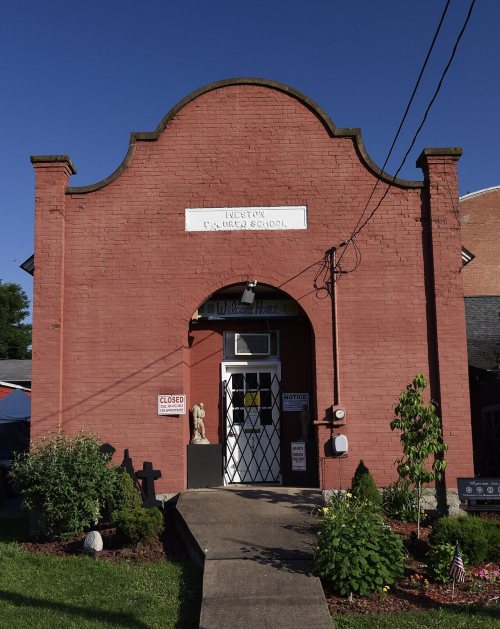
6 listings: 3 buildings, among them the Weston State Hospital (a National Historic Landmark since 1990), 2 historic districts, the Weston Downtown Historic District and the Weston Downtown Residential Historic District, with 251 contributing buildings, and 1 site. 254 historic buildings in all.
How old are the homes in Weston?
38% of Weston’s homes were built before 1940 (Census estimate, ±6.8 points), against a typical 13% for a West Virginia town; the median home was built in 1953.
Founding dates: Wikidata, Wikipedia, the U.S. post office records of Blevins & Helbock (CC0) and the Census. Homes by year built: Census ACS 2020–24. National Register of Historic Places: National Park Service (list of May 22, 2026). Old photos, postcards and papers: Wikimedia Commons, the Library of Congress and other public archives, credited on each item’s page. Maps: U.S. Geological Survey historical topographic maps (via Esri) and Sanborn fire-insurance maps (Library of Congress). History text and census tables: Wikipedia (CC BY-SA 4.0). Places that used to be: USGS Geographic Names Information System (2021).
From Wikimedia Commons (17), the Library of Congress (1), the National Register of Historic Places (6), Wikipedia, Wikidata and Wikipedia for famous people, U.S. Geological Survey historical maps, U.S. Census counts (via Wikipedia), the US Post Offices dataset (Blevins & Helbock), the USGS Geographic Names Information System, Sanborn fire insurance maps (Library of Congress) and old county and town histories (Internet Archive). Archive images are copied here with their credits and licenses, shown on each photo’s page. Refreshed monthly.


 ★ Landmark




 1896
 1902
 1902
 1902
 1902
 1902
 1902
 2011
 2006
 2006
 2006
 2006
 2006
 2004


