Elkins’ post office opened in 1889, and 37% of its homes were built before 1940
More historic than 87% of U.S. towns · #16 of 61 in West Virginia. What drives it
22 places in town are on the National Register, among them 3 National Historic Landmarks and seven historic districts with 610 buildings between them. Below: 4 old photos and papers, maps from 1899 on, and the census since 1890.
The Elkins post office opened in 1889, the earliest record of the town by name. Another post office, Leadsville (1822), opened inside today’s city and later closed.
First census: 737 in 18902020 census: 6,934137 years
How historic is Elkins?
A
More historic than 87% of U.S. towns, on its age, its old homes and the National Register.
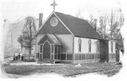
Founding year: the first Elkins post office (Blevins & Helbock, CC0).The full story ↓
History grade
What drives Elkins’ History grade
On its age, its old homes and the National Register, Elkins is more historic than 87% of U.S. towns, #16 of 61 in West Virginia. Its National Register listings hold the grade up; its age pulls it down.
A
HistoryA character grade: shown, never part of Elkins’ overall grade.
West Virginia towns list more on the Register than most of the country (a typical West Virginia town has 29.6 per 10,000 residents, the U.S. 2.4), so Elkins’ 926 sits above most of its state (92% of West Virginia towns have fewer) while its 631 historic buildings outnumber those of 98% of U.S. towns.
How sure. Graded on any two of the three inputs instead, the letter would range from B+ to A+. The pre-1940 share is a Census survey estimate (±5.4 points). The founding year is the first post office, not a stated founding date.
Founding year: the first post office (other dates in Quick answers). Homes: Census ACS 2020–24. National Register: National Park Service, May 2026 list; each listing counted once (boundary changes and added documentation belong to their listing), and a historic district counts its contributing buildings. How TownRatings grades history →
What stands out about Elkins’ past
Read from the archive, the National Register and the record. The page puts what stands out first.
The country’s official list of buildings and places worth saving. 3 are National Historic Landmarks, the highest tier. Boundary changes and added documentation are counted with their listing.
Thomas Skidmore (ca. 1733-1807), born in Maryland, obtained a title to 400 acres of land (“by virtue of a settlement”) in the future Elkins area before 1778. This land, on the east side of the Tygart Valley River, was surveyed by John Poage in 1780 and included the land that is now most of downtown Elkins. Thus, Skidmore was probably the first white settler in what became Elkins.
Passages that mention Elkins, cut from the printed page as they were published.
A history of Randolph County, West Virginia, from its earliest exploration and settlement to the present time1916 · page 283Read the page →
Read the text
he worked on the farm until he was married, lie purchased a farm of 100 acres adjoining 72 acres willed to him by his father. Both tracts were in Roaring Creek coal field and he farmed them until the city of Elkins begun to build, when he was employed on the construction of the West Virginia Central Railway shops, the Hotel Randolph, National and Trust Bank buildings, court house, Davis and Elkins College and the central high school building. In 1900 he moved his
Text read by machine from the scan; it may contain errors.
The history of Randolph County, West Virginia. From its earliest settlement to the present, embracing records of all the leading families, reminiscences and traditions ..1898 · page 366Read the page →
Read the text
At Elkins he has built and has given to the Presbyterian parish a beautiful stone edifice known as the Davis Memorial Church; and in conjunction with his son-in-law, Senator Elkins, has arranged to endow a Presbyterian College to be located at Elkins. His vigor of mind and body at the age of 75 is remarkable. Life has been full of toil, but his spirit is as buoyant, his interest in affairs as keen, and his activity as driving as when he first twisted a brake on the Baltimore and Ohio Railroad.
Text read by machine from the scan; it may contain errors.
A history of Randolph County, West Virginia, from its earliest exploration and settlement to the present time1916 · page 255Read the page →
Read the text
The City of Elkins was laid off into lots in 1889. It was named for Hon. S. B. Elkins, who with Honorable H. G. Davis and Honorable Richard Kearns, built magnificent residences on adjacent eminences. On August 18, 1889, trains commenced running into the town. The railroad was extended to Beverly and Belington in 1891, and to Huttonsville a few years later. A branch was also built, known as the C.
Text read by machine from the scan; it may contain errors.
The history of Randolph County, West Virginia. From its earliest settlement to the present, embracing records of all the leading families, reminiscences and traditions ..1898 · page 290Read the page →
Read the text
This Democratic newspaper printed at Elkins, began its existence September 13, 1889, under the ownership and management of James A. Bent and Floyd Triplett. It was published in the third building erected in the town of Elkins, sixteen by twenty-four feet, one story high and located on an alley. It was not known at that time that it was on an alley, for the world expanded in unbroken meadows on all sides; but the subsequent building of the town developed the fact that it was located on an alley.
Text read by machine from the scan; it may contain errors.
Scans and text from the Internet Archive. Books published in 1930 or earlier, which are in the public domain.
Timeline
Elkins, 1822 to 1996
Woven from the archive, old maps, post office records, the National Register and the people born here.
Nothing in the archives for these yearsWeddings on Main Street, storms, parades, school pictures, the old store. If it’s in your family album, it belongs here.
Every edition of the U.S. Geological Survey’s map of Elkins. Tap a year, or press play to watch the town change.
1909Elkins sheet · 1:62,500
U.S. Geological Survey historical topographic maps (public domain), via Esri’s collection of the scans. The red ring marks the center of Elkins.
Every building
Elkins, building by building, 1899–1923
Fire insurance maps drew every building, what it was made of and what it was used for, so insurers could price the risk of fire. Pick a year, then a sheet.
Lost post offices, old corners and places now gone
Elkins’s post office has been open since 1889. Another post office, Leadsville, opened and closed inside today’s town.
Leadsville
1822–1891
Elkins
1889–today
18201920today
Hamlets and corners on the map
Elkins JunctionLeadsville
Gone or out of use
Central SchoolschoolFirst Ward SchoolschoolMemorial General HospitalhospitalRandolph County JailbuildingVirginia African Methodist Episcopal Chapelchurch
US Post Offices dataset (Blevins & Helbock, CC0). Places and cemeteries from the USGS Geographic Names Information System (2021).
Stories next door
History across the town line
Each neighbor’s History grade, on the same three inputs.
The Elkins post office opened in 1889, the earliest record of the town by name (U.S. post office records).
How does Elkins rank for history?
Elkins is more historic than 87% of U.S. towns, #16 of 61 in West Virginia. The History grade combines the town’s founding era, the share of homes built before 1940 and its National Register listings. It’s a character grade, so it isn’t part of the overall grade. How it works.
What is on the National Register in Elkins?
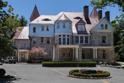
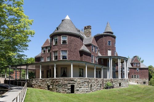
22 listings, 3 of them National Historic Landmarks: 14 buildings, among them the Graceland (a National Historic Landmark since 1996), 7 historic districts with 610 contributing buildings, and 1 site. 631 historic buildings in all.
How old are the homes in Elkins?
37% of Elkins’ homes were built before 1940 (Census estimate, ±5.4 points), against a typical 13% for a West Virginia town; the median home was built in 1952.
Founding dates: Wikidata, Wikipedia, the U.S. post office records of Blevins & Helbock (CC0) and the Census. Homes by year built: Census ACS 2020–24. National Register of Historic Places: National Park Service (list of May 22, 2026). Old photos, postcards and papers: Wikimedia Commons, the Library of Congress and other public archives, credited on each item’s page. Maps: U.S. Geological Survey historical topographic maps (via Esri) and Sanborn fire-insurance maps (Library of Congress). History text and census tables: Wikipedia (CC BY-SA 4.0). Places that used to be: USGS Geographic Names Information System (2021).
From Wikimedia Commons (3), the Library of Congress (1), Wikidata (2), the National Register of Historic Places (22), Wikipedia, Wikidata and Wikipedia for famous people, U.S. Geological Survey historical maps, U.S. Census counts (via Wikipedia), the US Post Offices dataset (Blevins & Helbock), the USGS Geographic Names Information System, Sanborn fire insurance maps (Library of Congress) and old county and town histories (Internet Archive). Archive images are copied here with their credits and licenses, shown on each photo’s page. Refreshed monthly.



 ★ Landmark
 ★ Landmark
 ★ Landmark




 1897


