Guest, Sign inJoin

Post to East Bank

We’ll email a one-tap link to publish your post. No password, and nothing is public until you click it.
Already a member? Sign in
–Not graded
History · East Bank

East Bank dates to 1889, and 16% of its homes were built before 1940

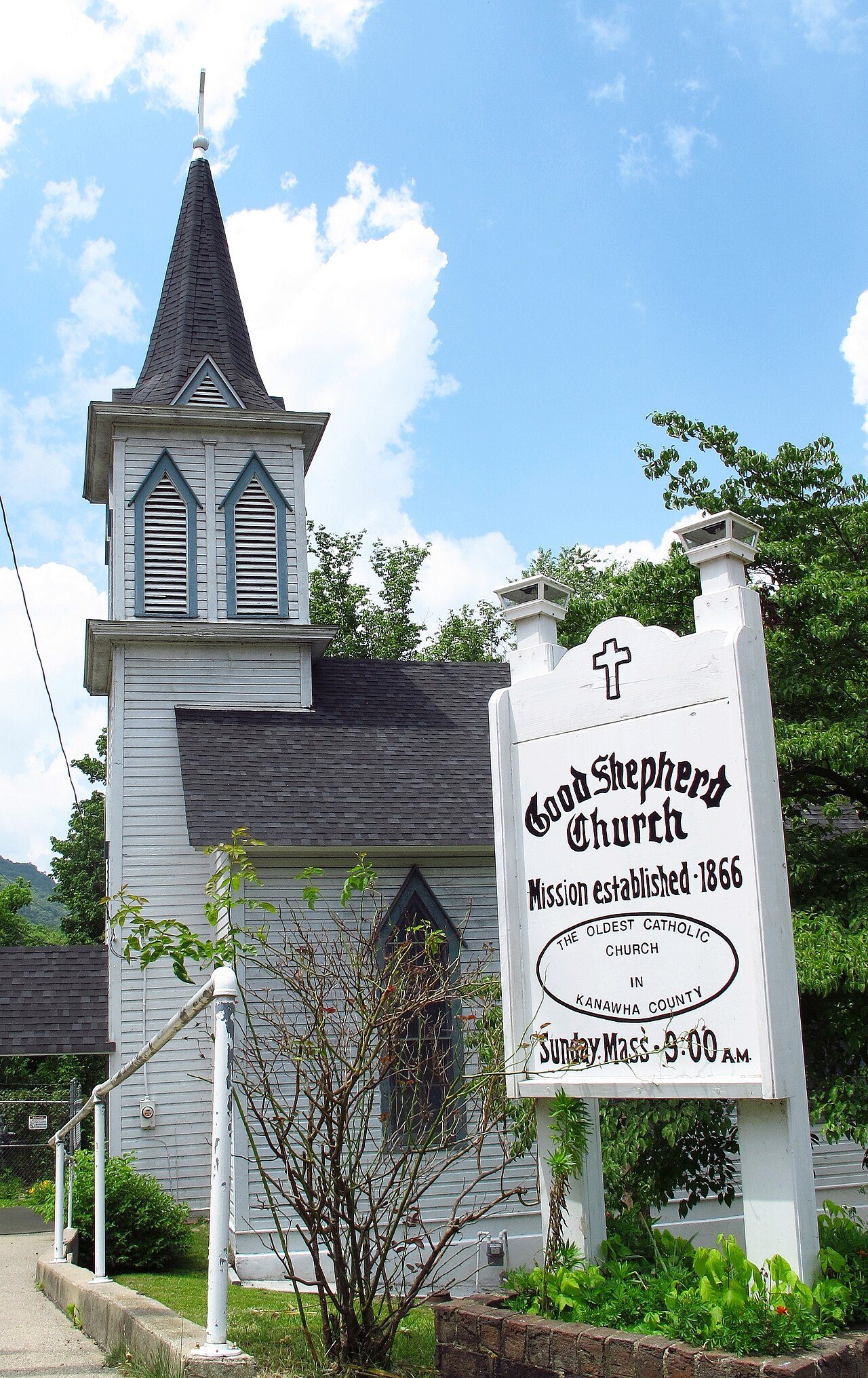
Its Register listing is the Good Shepherd Church. Below: maps from 1910 on and the census since 1900.

1889founded
1on the National Register
16%homes built before 1940
Quick answers

How East Bank began

When was East Bank founded?

1889

East Bank dates its founding to 1889 (Wikipedia’s history). The census first counted it in 1900.

First census: 468 in 19002020 census: 822137 years
Founding year: Wikipedia. First post office: 1875.The full story ↓

What stands out about East Bank’s past

Read from the archive, the National Register and the record. The page puts what stands out first.

★ What stands out · Help out

Start East Bank’s collection

The first neighbors to add old photos shape how East Bank’s history is told.

Decades since 1900 with photos
00s10s20s30s40s50s60s70s80s90s
0 of 10 decades. The empty ones are waiting for someone’s album.
People over time

East Bank, census by census

02004006008001,0001,2001900192019401960198020002020Peak: 1,155

Peaked at 1,155 in 1980; 822 people lived here in 2020.

13 censuses, 1900–2020.

U.S. Census Bureau decennial counts, from the census table on East Bank’s Wikipedia page.

Places that used to be

Lost post offices, places now gone and burying grounds

Two other post offices opened and closed inside today’s town.

Hampton
1875–1887
Pryor
1887–1890
Eastbank
1890–today
18701950today
Gone or out of use
East Bank High Schoolschool
2cemeteries and burying grounds inside East Bank
Good Shepherd ChurchIndependent Order of Oddfellows

US Post Offices dataset (Blevins & Helbock, CC0). Places and cemeteries from the USGS Geographic Names Information System (2021).

The story

How East Bank came to be

From Wikipedia’s history of East Bank.

Read it all →

East Bank was incorporated in 1889 by special charter enacted by the West Virginia Legislature. It is so named on account of the town's location on the east side of the Kanawha River.

Text from Wikipedia, licensed CC BY-SA 4.0.

From the old history books

What they wrote about East Bank in 1911

Passages that mention East Bank, cut from the printed page as they were published.

one of the first settlers and the last white man killed by the Indians in Kanawha, (so said), and she was Nancy Morris of Cabell County, in Teays Valley. He lived at East Bank, and practiced medicine, and one season along in the upper part of the county there was (about 1845), an epidemic of typhoi…
History of Charleston and Kanawha County, West Virginia1911 · page 289Read the page →
Read the text

one of the first settlers and the last white man killed by the Indians in Kanawha, (so said), and she was Nancy Morris of Cabell County, in Teays Valley. He lived at East Bank, and practiced medicine, and one season along in the upper part of the county there was (about 1845), an epidemic of typhoid fever, and about one half of those that took it died. He was

Text read by machine from the scan; it may contain errors.
Operator, East Bank Mining Company; No complete record of the quantity of coal mine, East Bank; postofnce, East Bank. mined in Kanawha county has been kept in the We append herewith an approximate stateoffice of the Chief of the Department of Mines ment of the coal and coke shipments of Kaprior to …
History of Charleston and Kanawha County, West Virginia1911 · page 326Read the page →
Read the text

Operator, East Bank Mining Company; No complete record of the quantity of coal mine, East Bank; postofnce, East Bank. mined in Kanawha county has been kept in the We append herewith an approximate stateoffice of the Chief of the Department of Mines ment of the coal and coke shipments of Kaprior to the year 1883.

Text read by machine from the scan; it may contain errors.

Scans and text from the Internet Archive. Books published in 1930 or earlier, which are in the public domain.

Timeline

East Bank, 1875 to 1980

Woven from the archive, old maps, post office records, the National Register and the people born here.

  1. 19th century
  2. 1875Post officeThe Hampton post office opens
  3. 1877BuiltGood Shepherd Church is built
  4. 1887Post officeThe Hampton post office closes
  5. 1887Post officeThe Pryor post office opens
  6. 1889
    FoundingEast Bank is established
  7. 1890Post officeThe Pryor post office closes
  8. 1890Post officeThe Eastbank post office opens
  9. 20th century
  10. 1910On the mapFirst mapped by the U.S. Geological Survey
  11. 1980CensusPopulation peaks at 1,155
By decade

East Bank, decade by decade

On the map

East Bank on the map, 1910 to 1971

Every edition of the U.S. Geological Survey’s map of East Bank. Tap a year, or press play to watch the town change.

East Bank on the 1910 USGS mapEast Bank on the 1928 USGS mapEast Bank on the 1931 USGS mapEast Bank on the 1965 USGS mapEast Bank on the 1971 USGS map1910Montgomery sheet · 1:62,500

U.S. Geological Survey historical topographic maps (public domain), via Esri’s collection of the scans. The red ring marks the center of East Bank.

On the National Register

1 historic place in East Bank

The country’s official list of buildings and places worth saving.

place listed
1
National Historic Landmarks
0
none yet
historic buildings protected
1
each building in a district counts
first listed
1990
Good Shepherd Church
Buildings

Architectural styles listings

Late Gothic Revival1

National Park Service, National Register of Historic Places. Photos from Wikimedia Commons, credited on each place’s page.

Famous people

Famous people close to East Bank

Nobody well known was born in East Bank itself, so here are the best known from just nearby.

See all →

Questions about East Bank’s history

What year was East Bank founded?

In 1889, according to Wikipedia’s history of the town. East Bank’s post office opened in 1875, and the census of 1900 counted 468 people here.

What is on the National Register in East Bank?

One place: the Good Shepherd Church (listed 1990).

Memory lane

What the archives can’t tell you, neighbors can.

Town Square →
Start a conversation
Sources

Where this page comes from

Founding dates: Wikidata, Wikipedia, the U.S. post office records of Blevins & Helbock (CC0) and the Census. Homes by year built: Census ACS 2020–24. National Register of Historic Places: National Park Service (list of May 22, 2026). Old photos, postcards and papers: Wikimedia Commons, the Library of Congress and other public archives, credited on each item’s page. Maps: U.S. Geological Survey historical topographic maps (via Esri) and Sanborn fire-insurance maps (Library of Congress). History text and census tables: Wikipedia (CC BY-SA 4.0). Places that used to be: USGS Geographic Names Information System (2021). How TownRatings grades history →

From Wikimedia Commons (4), the National Register of Historic Places (1), Wikipedia, U.S. Geological Survey historical maps, U.S. Census counts (via Wikipedia), the US Post Offices dataset (Blevins & Helbock), the USGS Geographic Names Information System and old county and town histories (Internet Archive). Archive images are copied here with their credits and licenses, shown on each photo’s page. Refreshed monthly.