Buckhannon’s post office opened in 1804, and 32% of its homes were built before 1940
More historic than 96% of U.S. towns · #5 of 61 in West Virginia. What drives it
5 places in town are on the National Register, among them two historic districts with 401 buildings between them. Below: 3 old photos and papers, maps from 1894 on, and the census since 1860.
The Buckhannon post office opened in 1804, the earliest record of the town by name. Another post office, South Buckhannon (1910), opened inside today’s city and later closed.
First census: 427 in 18602020 census: 5,186222 years
How historic is Buckhannon?
A+
More historic than 96% of U.S. towns, on its age, its old homes and the National Register.
Founding year: the first Buckhannon post office (Blevins & Helbock, CC0).The full story ↓
History grade
What drives Buckhannon’s History grade
On its age, its old homes and the National Register, Buckhannon is more historic than 96% of U.S. towns, #5 of 61 in West Virginia. All 3 inputs are above most U.S. towns; its National Register listings ranks highest and its age lowest.
A+
HistoryA character grade: shown, never part of Buckhannon’s overall grade.
West Virginia towns list more on the Register than most of the country (a typical West Virginia town has 29.6 per 10,000 residents, the U.S. 2.4), so Buckhannon’s 805 sits above most of its state (90% of West Virginia towns have fewer) while its 412 historic buildings outnumber those of 96% of U.S. towns.
How sure. Graded on any two of the three inputs instead, the letter would range from A to A+. The pre-1940 share is a Census survey estimate (±7.8 points). The founding year is the first post office, not a stated founding date.
Founding year: the first post office (other dates in Quick answers). Homes: Census ACS 2020–24. National Register: National Park Service, May 2026 list; each listing counted once (boundary changes and added documentation belong to their listing), and a historic district counts its contributing buildings. How TownRatings grades history →
What stands out about Buckhannon’s past
Read from the archive, the National Register and the record. The page puts what stands out first.
Fire insurance maps drew every building, what it was made of and what it was used for, so insurers could price the risk of fire. Pick a year, then a sheet.
According to tradition, the first settlers in the Buckhannon River Valley were brothers John and Samuel Pringle. John and Samuel were soldiers serving in the British army during the French and Indian War (Seven Years' War) who, in 1761, deserted their posts at Fort Pitt (present-day Pittsburgh, Pennsylvania). They traveled southward and upstream along the Monongahela and Tygart Valley rivers, continuing up what is now called the Buckhannon River. John and Samuel Pringle are said to have arrived in present-day Upshur County in 1764 and took up residence in the hollow stump of an American sycamore tree later named the Pringle Tree. They lived there for three years, surviving on game and fish. When they ran out of bullets in 1765, John made the journey to settlements along the South Branch Potomac River to purchase more and found out from the locals that the war was over and the brothers w…
Passages that mention Buckhannon, cut from the printed page as they were published.
The history of Upshur county, West Virginia, from its earliest exploration and settlement to the present time ..1907 · page 330Read the page →
Read the text
In September, 1889, the Buckhannon and West Fork railroad and the Weston and Centerville railroad were merged into the Clarksburg, Weston and Midland and on February 6, 1890, the latter absorbed the Buckhannon River railroad which was incorporated on the 2oth day of July, 1889, for the purpose of building a railroad up the Buckhannon river to Pickens. With the absorption of all these roads a reorganization took place and a new name was given to the system, namely, The West Virginia and Pittsburg Railroad.
Text read by machine from the scan; it may contain errors.
The history of Upshur county, West Virginia, from its earliest exploration and settlement to the present time ..1907 · page 467Read the page →
Read the text
Mr. Hanson came to West Virginia in 1872, locating first at Clarksburg; in 1881 he moved to Buckhannon and went into the hardware business; in 1883 he was elected Mayor of the town of Buckhannon and so successful was his administration, that the honor of Mayor was conferred upon him two more terms. He was very instrumental in having located at Buckhannon the West Virginia Conference Seminary now known as the W. Va. Wesleyan College.
Text read by machine from the scan; it may contain errors.
Scans and text from the Internet Archive. Books published in 1930 or earlier, which are in the public domain.
Timeline
Buckhannon, 1777 to 1977
Woven from the archive, old maps, post office records, the National Register and the people born here.
Nothing in the archives for these yearsWeddings on Main Street, storms, parades, school pictures, the old store. If it’s in your family album, it belongs here.
Lost post offices, old corners, places now gone and burying grounds
Buckhannon’s post office has been open since 1804. Another post office, South Buckhannon, opened and closed inside today’s town.
Buckhannon
1804–today
South Buckhannon
1910–1914
18001910today
Hamlets and corners on the map
HeavnerSouth Buckhannon
Gone or out of use
Academy Primary SchoolschoolBuckhannon Upshur Intermediate SchoolschoolCentral Elementary SchoolschoolLeonard Memorial HospitalhospitalMain Street Primary SchoolschoolSimpson Memorial Methodist Episcopal Churchchurch
1cemetery inside Buckhannon
Buckhannon Memorial
US Post Offices dataset (Blevins & Helbock, CC0). Places and cemeteries from the USGS Geographic Names Information System (2021).
Questions about Buckhannon’s history
What year was Buckhannon founded?
The Buckhannon post office opened in 1804, the earliest record of the town by name (U.S. post office records).
How does Buckhannon rank for history?
Buckhannon is more historic than 96% of U.S. towns, #5 of 61 in West Virginia. The History grade combines the town’s founding era, the share of homes built before 1940 and its National Register listings. It’s a character grade, so it isn’t part of the overall grade. How it works.
What is on the National Register in Buckhannon?
5 listings: 3 buildings, among them the Agnes Howard Hall (listed 1983, the first), and 2 historic districts, the Downtown Buckhannon Historic District and the Buckhannon Central Residential Historical District, with 401 contributing buildings. 412 historic buildings in all.
How old are the homes in Buckhannon?
32% of Buckhannon’s homes were built before 1940 (Census estimate, ±7.8 points), against a typical 13% for a West Virginia town; the median home was built in 1956.
Founding dates: Wikidata, Wikipedia, the U.S. post office records of Blevins & Helbock (CC0) and the Census. Homes by year built: Census ACS 2020–24. National Register of Historic Places: National Park Service (list of May 22, 2026). Old photos, postcards and papers: Wikimedia Commons, the Library of Congress and other public archives, credited on each item’s page. Maps: U.S. Geological Survey historical topographic maps (via Esri) and Sanborn fire-insurance maps (Library of Congress). History text and census tables: Wikipedia (CC BY-SA 4.0). Places that used to be: USGS Geographic Names Information System (2021).
From Wikimedia Commons (10), the Library of Congress (1), Wikidata (1), the National Register of Historic Places (5), Wikipedia, Wikidata and Wikipedia for famous people, U.S. Geological Survey historical maps, U.S. Census counts (via Wikipedia), the US Post Offices dataset (Blevins & Helbock), the USGS Geographic Names Information System, Sanborn fire insurance maps (Library of Congress) and old county and town histories (Internet Archive). Archive images are copied here with their credits and licenses, shown on each photo’s page. Refreshed monthly.


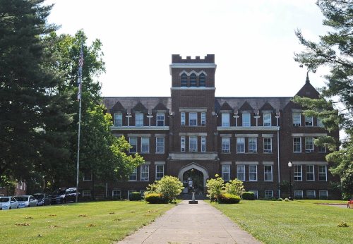


 2012
 2011
 2011
 2006
 2006
 2004
 2000
 2000


