Waupun dates to 1839, and 22% of its homes were built before 1940
More historic than 91% of U.S. towns · #36 of 362 in Wisconsin. What drives it
8 places in town are on the National Register, among them three historic districts with 52 buildings between them. Below: 10 old photos and papers, maps from 1955 on, and the census since 1860.
Founding year: Wikidata; Wikipedia’s history section gives the same year. First post office: 1840.The full story ↓
History grade
What drives Waupun’s History grade
On its age, its old homes and the National Register, Waupun is more historic than 91% of U.S. towns, #36 of 362 in Wisconsin. All 3 inputs are above most U.S. towns; its National Register listings ranks highest and its share of homes from before 1940 lowest.
A
HistoryA character grade: shown, never part of Waupun’s overall grade.
Wisconsin towns list more on the Register than most of the country (a typical Wisconsin town has 3.0 per 10,000 residents, the U.S. 2.4), so Waupun’s 49.2 sits above most of its state (88% of Wisconsin towns have fewer) while its 55 historic buildings outnumber those of 86% of U.S. towns.
How sure. Graded on any two of the three inputs instead, the letter would range from A− to A. The pre-1940 share is a Census survey estimate (±4.9 points). Two sources give 1839.
Founding year: Wikidata (other dates in Quick answers). Homes: Census ACS 2020–24. National Register: National Park Service, May 2026 list; each listing counted once (boundary changes and added documentation belong to their listing), and a historic district counts its contributing buildings. How TownRatings grades history →
What stands out about Waupun’s past
Read from the archive, the National Register and the record. The page puts what stands out first.
Waupun was founded in 1839 by Seymour Wilcox, the first settler along the Rock River in what was then deciduous forested land. Wilcox chose the land on recommendation of John Bannister, the first surveyor of Fond du Lac County, who reported to the government office in Green Bay that "the Rock River Valley was the most beautiful and fertile he had ever seen." Wilcox surveyed the land himself in late fall of 1838, returning to Green Bay for the winter. In February 1839 he returned to the plot he laid out accompanied by two men, John N. Ackerman and Hiram Walker, who were interested in the powerful river and fertile land. They quickly nailed together a shanty to four bur oaks and began building a suitable cabin for the Wilcox homestead. Leaving Ackerman and Walker to finish, Wilcox returned to Green Bay to bring his family to their new home. They reached Waupun on March 20, 1839.
Passages that mention Waupun, cut from the printed page as they were published.
The history of Dodge county, Wisconsin, containing ... its early settlement, growth ... an extensive and minute sketch of its cities ... war record, biographical sketches1880 · page 510Read the page →
Read the text
The Citizens' Bank. — After the failure of the Corn Exchange Bank, in 1875, the village of Waupun had no bank until early in 1876 when Alraon Atwood, of the town of Waupun, started the Citizens' Bank in the old Corn Exchange building. Almon Atwood was President, and A. Robinson, Cashier. The enterprise not proving satisfactory to its projector, business was discontinued, and the bank closed in February, 1877.
Text read by machine from the scan; it may contain errors.
The history of Dodge county, Wisconsin, containing ... its early settlement, growth ... an extensive and minute sketch of its cities ... war record, biographical sketches1880 · page 409Read the page →
Read the text
This is the center of the northern tier of towns, being Town 13 north, Range 15 east, and is very thickly settled. Two railroads traverse it from north to south, viz.. the C, M. & St. P. and the C. & N. There is a small station on the latter known as Atwater Station, while on the former is Chester Station, situated near the northern line and about two miles east of the city of Waupun. A portion of the city of Waupun being situated in Dodge County, therefore its history is given in its proper place in this work The State Penitentiary is here located. There are several cheese-factories in this town, and this branch of 'industry is largely developed. The town business is transacted at Atwater Station. Population in 1870 was 1,876. In 1879, there
Text read by machine from the scan; it may contain errors.
Scans and text from the Internet Archive. Books published in 1930 or earlier, which are in the public domain.
Timeline
Waupun, 1839 to 1955
Woven from the archive, old maps, post office records, the National Register and the people born here.
Nothing in the archives for these yearsWeddings on Main Street, storms, parades, school pictures, the old store. If it’s in your family album, it belongs here.
In 1839, according to Wikidata and Wikipedia’s history of the town. Waupun’s post office opened in 1840, and the census of 1860 counted 1,736 people here.
How does Waupun rank for history?
Waupun is more historic than 91% of U.S. towns, #36 of 362 in Wisconsin. The History grade combines the town’s founding era, the share of homes built before 1940 and its National Register listings. It’s a character grade, so it isn’t part of the overall grade. How it works.
What is on the National Register in Waupun?
8 listings: 3 buildings, 3 historic districts, the Wisconsin State Prison Historic District, the Central State Hospital Historic District and the Waupun Commercial Historic District, with 52 contributing buildings, and 2 objects. 55 historic buildings in all.
How old are the homes in Waupun?
22% of Waupun’s homes were built before 1940 (Census estimate, ±4.9 points), against a typical 12% for a Wisconsin town; the median home was built in 1968.
Founding dates: Wikidata, Wikipedia, the U.S. post office records of Blevins & Helbock (CC0) and the Census. Homes by year built: Census ACS 2020–24. National Register of Historic Places: National Park Service (list of May 22, 2026). Old photos, postcards and papers: Wikimedia Commons, the Library of Congress and other public archives, credited on each item’s page. Maps: U.S. Geological Survey historical topographic maps (via Esri) and Sanborn fire-insurance maps (Library of Congress). History text and census tables: Wikipedia (CC BY-SA 4.0). Places that used to be: USGS Geographic Names Information System (2021).
From Wikimedia Commons (2), the Library of Congress (8), Wikidata (2), the National Register of Historic Places (8), Wikipedia, Wikidata and Wikipedia for famous people, U.S. Geological Survey historical maps, U.S. Census counts (via Wikipedia), the US Post Offices dataset (Blevins & Helbock), the USGS Geographic Names Information System and old county and town histories (Internet Archive). Archive images are copied here with their credits and licenses, shown on each photo’s page. Refreshed monthly.


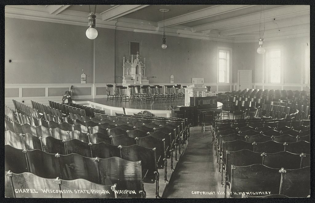





 1909
 1911
 1911
 1911
 1911
 1911
 1911


