

The story so far
Washington, in brief
Wikipedia doesn’t have a history of Washington yet. The photos, dates and memories neighbors add here are how it gets written.
Between the 2010 and 2020 censuses its population grew from 708 to 777 (+10%).
Each edition grades its towns against each other only.
8 places in town are on the National Register, among them two historic districts with 15 buildings between them. Below: maps from 1960 on and old-book passages.
Read from the archive, the National Register and the record. The page puts what stands out first.
The first neighbors to add old photos shape how Washington’s history is told.
The country’s official list of buildings and places worth saving.


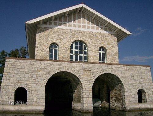

National Park Service, National Register of Historic Places. Photos from Wikimedia Commons, credited on each place’s page.
Wikipedia doesn’t have a history of Washington yet. The photos, dates and memories neighbors add here are how it gets written.
Between the 2010 and 2020 censuses its population grew from 708 to 777 (+10%).
Passages that mention Washington, cut from the printed page as they were published.

But it is to be remembered that the same result would be reached if that part of the original county of Washington, which now retains the name, had been set off from the remaining part of the county and called by another name ; this would clearly have given the Legislature power to establish a county seat for the county thus set off, for it wonld have had none within its limits ; and by passing an act annexing Washington County to it, the only result would be the removal of the county seat of the original county of Washington and the change of its name, which, of course, the Legislature could by another act restore.
Text read by machine from the scan; it may contain errors.
be paid by Ozaukee to Washington County. The final contract of settlement was as follows : The undersigned, J. C. Downs, Harvey Moore and Adolph Zimmerman, Committee appointed by a resolution of the Board of Supervisors of the county of Ozaukee, in the State of Wisconsin, and invested with full power to meet a Committee on the part of Washington County, in said State, and to make and adjust a final settlement with said County of Washington, and William Rolin, .lames Holfe and Chauncey Gray, Committee appointed by a resolution of the Hoard of Supervisors of Washington County to meet a Committee on the part of Ozaukee County for the same purpose, and with the same persons, have agreed upon and do hereby agree upon a final settlement of all claims, accounts and indebtedness of every kind, nature and description, between the said counties of Washington and
Text read by machine from the scan; it may contain errors.Scans and text from the Internet Archive. Books published in 1930 or earlier, which are in the public domain.
Woven from the archive, old maps, post office records, the National Register and the people born here.
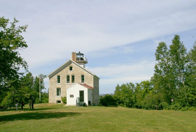
BuiltPottawatomie Lighthouse is builtBuiltPilot Island Light is builtBuiltPlum Island Range Rear Light is built On the mapFirst mapped by the U.S. Geological Survey
Weddings on Main Street, storms, parades, school pictures, the old store. If it’s in your family album, it belongs here.
Every edition of the U.S. Geological Survey’s map of Washington. Tap a year, or press play to watch the town change.

U.S. Geological Survey historical topographic maps (public domain), via Esri’s collection of the scans. The red ring marks the center of Washington.
Nobody well known was born in Washington itself, so here are the best known from just nearby.
Another post office, Detroit Harbor, opened and closed inside today’s town.
US Post Offices dataset (Blevins & Helbock, CC0). Places and cemeteries from the USGS Geographic Names Information System (2021).
Each neighbor’s History grade, on the same three inputs.
8 listings: 3 buildings, 2 historic districts, the Thordarson Estate Historic District and the Plum island Life-Saving and Light Station, with 15 contributing buildings, 2 sites, and 1 structure. 19 historic buildings in all.
What the archives can’t tell you, neighbors can.
Founding dates: Wikidata, Wikipedia, the U.S. post office records of Blevins & Helbock (CC0) and the Census. Homes by year built: Census ACS 2020–24. National Register of Historic Places: National Park Service (list of May 22, 2026). Old photos, postcards and papers: Wikimedia Commons, the Library of Congress and other public archives, credited on each item’s page. Maps: U.S. Geological Survey historical topographic maps (via Esri) and Sanborn fire-insurance maps (Library of Congress). History text and census tables: Wikipedia (CC BY-SA 4.0). Places that used to be: USGS Geographic Names Information System (2021). How TownRatings grades history →
From the National Register of Historic Places (8), U.S. Geological Survey historical maps, the US Post Offices dataset (Blevins & Helbock), the USGS Geographic Names Information System and old county and town histories (Internet Archive). Archive images are copied here with their credits and licenses, shown on each photo’s page. Refreshed monthly.


