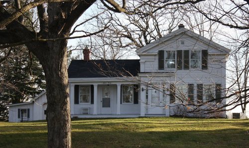
Neenah dates to 1873, and 1 of its places is on the National Register
More historic than 42% of U.S. towns · #233 of 362 in Wisconsin. What drives it
Most of Neenah was built recently: 9% of its homes predate 1940 and the median home dates from 1984. Its Register listing is the Gorham Vining P. House. Its Register listing is the Gorham Vining P. House. Below: 3 old photos and papers, maps from 1884 on, and the census since 1860.
Founding year: Wikidata. First post office: 1876.The full story ↓
History grade
What drives Neenah’s History grade
On its age, its old homes and the National Register, Neenah is more historic than 42% of U.S. towns, #233 of 362 in Wisconsin. Its National Register listings hold the grade up; its age pulls it down.
C+
HistoryA character grade: shown, never part of Neenah’s overall grade.
Wisconsin towns list more on the Register than most of the country (a typical Wisconsin town has 3.0 per 10,000 residents, the U.S. 2.4), so Neenah’s 2.7 sits near the middle of its state (61% of Wisconsin towns have fewer) while its 1 listings outnumber those of 51% of U.S. towns.
NoteThe founding year comes from Wikidata alone; no second source gives 1873.
How sure. Graded on any two of the three inputs instead, the letter would range from C to B−. The pre-1940 share is a Census survey estimate (±5.8 points).
Founding year: Wikidata (other dates in Quick answers). Homes: Census ACS 2020–24. National Register: National Park Service, May 2026 list; each listing counted once (boundary changes and added documentation belong to their listing), and a historic district counts its contributing buildings. How TownRatings grades history →
What stands out about Neenah’s past
Read from the archive, the National Register and the record. The page puts what stands out first.
Lost post offices, old corners and burying grounds
Two other post offices opened and closed inside today’s town.
Snell's Station
1876–1883
Snell
1883–1886
18701950today
Hamlets and corners on the map
Adella BeachRainbow BeachRicker BaySnells
2cemeteries and burying grounds inside Neenah
Greenlawn Memorial ParkSaint Margaret's
US Post Offices dataset (Blevins & Helbock, CC0). Places and cemeteries from the USGS Geographic Names Information System (2021).
Every building
Neenah, building by building, 1884–1913
Fire insurance maps drew every building, what it was made of and what it was used for, so insurers could price the risk of fire. Pick a year, then a sheet.
Neenah was named by Governor James Duane Doty from the Hoocąk word for "water" or "running water". It was the site of a Ho-Chunk village from at least the late 18th century through 1830. In 1830, Juliette Magill Kinzie and other European Americans called the site "Four-Legs' village" for a Ho-Chunk chief who resided there. It is Nįįňą in the Hoocąk language.
The U.S. government initially designated this area in 1835 as an industrial and agricultural mission to the Menominee people of the area. Early settlement by European Americans began a few years later, stimulated in large part by the proximity of the area to the Fox River.
Passages that mention Neenah, cut from the printed page as they were published.
History of Winnebago County, Wisconsin, and early history of the Northwest1880 · page 197Read the page →
Read the text
carding-mill to that side. This was the pioneer institution of its kind in this county and vicinity and was the nucleus of the present Menasha Woolen Mills. The Town of Neenah was organized February 11, 1847, (see Town of Neenah). This reminds us of an old story, occasionally revived relating to this word " Neenah; " to the effect that Governor Doty
Text read by machine from the scan; it may contain errors.
History of Winnebago County, Wisconsin, and early history of the Northwest1880 · page 198Read the page →
Read the text
In the spring of 1848, Harvey Jones became a permanent resident, having, as proprietor, caused a plat of the village of Winnebago Rapids, in the town of Neenah, to be recorded January 6, 1848. Soon after his arrival, he commenced the erection of a sawmill, Charles Lindsly being associated with him in the enterprise.
Text read by machine from the scan; it may contain errors.
Scans and text from the Internet Archive. Books published in 1930 or earlier, which are in the public domain.
Timeline
Neenah, 1873 to 1957
Woven from the archive, old maps, post office records, the National Register and the people born here.
Nothing in the archives for these yearsWeddings on Main Street, storms, parades, school pictures, the old store. If it’s in your family album, it belongs here.
In 1873, according to Wikidata. Neenah’s post office opened in 1876, and the census of 1860 counted 1,296 people here.
How does Neenah rank for history?
Neenah is more historic than 42% of U.S. towns, #233 of 362 in Wisconsin. The History grade combines the town’s founding era, the share of homes built before 1940 and its National Register listings. It’s a character grade, so it isn’t part of the overall grade. How it works.
What is on the National Register in Neenah?
One place: the Gorham Vining P. House (listed 1983).
How old are the homes in Neenah?
9% of Neenah’s homes were built before 1940 (Census estimate, ±5.8 points), against a typical 12% for a Wisconsin town; the median home was built in 1984.
Founding dates: Wikidata, Wikipedia, the U.S. post office records of Blevins & Helbock (CC0) and the Census. Homes by year built: Census ACS 2020–24. National Register of Historic Places: National Park Service (list of May 22, 2026). Old photos, postcards and papers: Wikimedia Commons, the Library of Congress and other public archives, credited on each item’s page. Maps: U.S. Geological Survey historical topographic maps (via Esri) and Sanborn fire-insurance maps (Library of Congress). History text and census tables: Wikipedia (CC BY-SA 4.0). Places that used to be: USGS Geographic Names Information System (2021).
From Wikimedia Commons (3), Wikidata (3), the National Register of Historic Places (1), Wikipedia, Wikidata and Wikipedia for famous people, U.S. Geological Survey historical maps, U.S. Census counts (via Wikipedia), the US Post Offices dataset (Blevins & Helbock), the USGS Geographic Names Information System, Sanborn fire insurance maps (Library of Congress) and old county and town histories (Internet Archive). Archive images are copied here with their credits and licenses, shown on each photo’s page. Refreshed monthly.


 1880
 1880