Fond du Lac’s post office opened in 1837, and 28% of its homes were built before 1940
More historic than 95% of U.S. towns · #15 of 362 in Wisconsin. What drives it
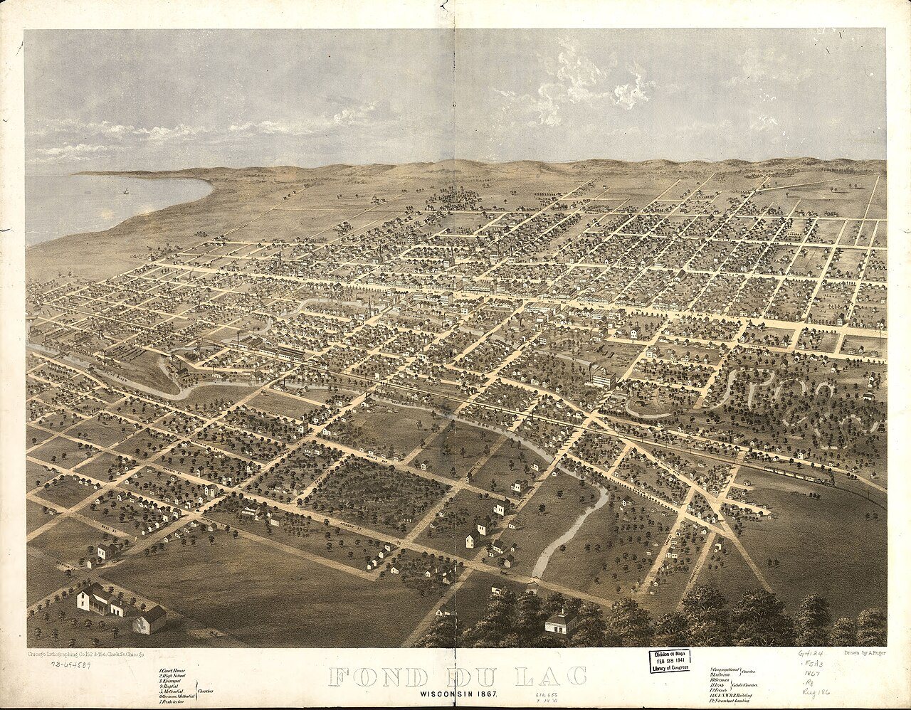
24 places in town are on the National Register, among them four historic districts with 188 buildings between them. Below: 5 old photos and papers, maps from 1884 on, and the census since 1860.
Founding year: the first Fond du Lac post office (Blevins & Helbock, CC0). Wikidata: 1843.The full story ↓
History grade
What drives Fond du Lac’s History grade
On its age, its old homes and the National Register, Fond du Lac is more historic than 95% of U.S. towns, #15 of 362 in Wisconsin. All 3 inputs are above most U.S. towns; its National Register listings ranks highest and its age lowest.
A
HistoryA character grade: shown, never part of Fond du Lac’s overall grade.
Wisconsin towns list more on the Register than most of the country (a typical Wisconsin town has 3.0 per 10,000 residents, the U.S. 2.4), so Fond du Lac’s 47.2 sits above most of its state (88% of Wisconsin towns have fewer) while its 210 historic buildings outnumber those of 94% of U.S. towns.
How sure. Graded on any two of the three inputs instead, the letter would still be A. The pre-1940 share (±2.1 points) is firm at this size. The founding year is the first post office, not a stated founding date; Wikidata’s 1843 falls in the same era, so the grade doesn’t depend on which one is used.
Founding year: the first post office (other dates in Quick answers). Homes: Census ACS 2020–24. National Register: National Park Service, May 2026 list; each listing counted once (boundary changes and added documentation belong to their listing), and a historic district counts its contributing buildings. How TownRatings grades history →
What stands out about Fond du Lac’s past
Read from the archive, the National Register and the record. The page puts what stands out first.
National Park Service, National Register of Historic Places. Photos from Wikimedia Commons, credited on each place’s page.
Every building
Fond du Lac, building by building, 1884–1915
Fire insurance maps drew every building, what it was made of and what it was used for, so insurers could price the risk of fire. Pick a year, then a sheet.
"Fond du Lac" is French for the "bottom of the lake", so named because of its location at the bottom (south end) of Lake Winnebago.
Native American tribes, primarily the Winnebagos but also the Potawatomi, Kickapoo, and Mascoutin lived or gathered in the area before Europeans arrived. Although the identity of the first European to colonize the southern end of Lake Winnebago is uncertain, it was probably Claude-Jean Allouez, followed by French fur trappers. James Doty, a federal judge for the western part of the Michigan Territory, thought the land at the foot of Lake Winnebago might be a good place for a city, so he and his partners bought land in the area.
Passages that mention Fond du Lac, cut from the printed page as they were published.
The history of Fond du Lac County, Wisconsin1880 · page 594Read the page →
Read the text
" I have this day formed a Union High School District in accordance with the expressed .desire of the districts comprising the same, which determination has been properly certified to by me as required by Section 2 of Chapter 138, of the General Laws of 1858, to be called the Union High School District of the city of Fond du Lac, of which the following is a description : The entire corporate limits of said city of Fond du Lac as designated in 'An Act to amend an act entitled an act to incorporate the city of Fond du Lac,' approved March 19, 1852, and as exhibited in the map of said city, published by George R. Harrison, in the year 1857. Such formation to take effect immediately."
Text read by machine from the scan; it may contain errors.
The history of Fond du Lac County, Wisconsin, containing ... war record, biographical sketches ... history of Wisconsin ... etc1880 · page 567Read the page →
Read the text
were followed in March, 1837, by Edward Pier and his family; how, soon after, other members of the Pier family arrived in the infant settlement ; and how, on the 1st day of March, 1838, the relatives were called to mourn the death of Fanny, wife of Colwert Pier, the pioneer woman of Fond du Lac County, and of what is now the city of Fond du Lac. On the 3d day of that month, while the few mourners were at the grave of the departed, John Bannister, a surveyor, •came from Green Bay to Fond du Lac with his family. He lived a short time (about a year) in the Company's log house, and then moved to a place south and outside of the present city limits.
Text read by machine from the scan; it may contain errors.
The history of Fond du Lac County, Wisconsin1880 · page 748Read the page →
Read the text
Four lines of railway cross the town of Fond du Lac — the C. & N. W., Air Line, Sheboygan & Fond du Lac and Narrow Gauge; but they maintain no stations within its limits outside of Fond du Lac City. Both branches of Fond du Lac River flow through its territory, furnishing limited water-powers on Sections 27, 22 and 16. Four toll roads are in this town : Empire Gravel Road, extending southeast from the city to Empire; one extending on Main street south ; one extending east through Taycheedah, and one southwest toward Waupun from the city. During 1879, a lively agitation was made against them ; indignation meetings were
Text read by machine from the scan; it may contain errors.
The history of Fond du Lac County, Wisconsin, containing ... war record, biographical sketches ... history of Wisconsin ... etc1880 · page 748Read the page →
Read the text
Four lines of railway cross the town of Fond du Lac — the C. & N. W., Air Line, Sheboygan & Fond du Lac and Narrow Gauge ; but they maintain no stations within its limits outside of Fond du Lac City. Both branches of Fond du Lac River flow through its territory, furnishing limited water-powers on Sections 27, 22 and 16. Four toll roads are in this town : Empire Gravel Road, extending southeast from the city to Empire ; one extending on Main street south ; one extending east through Taycheedah, and one southwest toward Waupun from the city. During 1879, a lively agitation was made against them ; indignation meetings were
Text read by machine from the scan; it may contain errors.
Scans and text from the Internet Archive. Books published in 1930 or earlier, which are in the public domain.
Timeline
Fond du Lac, 1827 to 1982
Woven from the archive, old maps, post office records, the National Register and the people born here.
Nothing in the archives for these yearsWeddings on Main Street, storms, parades, school pictures, the old store. If it’s in your family album, it belongs here.
The Fond du Lac post office opened in 1837, the earliest record of the town by name (U.S. post office records). Wikidata gives 1843.
How does Fond du Lac rank for history?
Fond du Lac is more historic than 95% of U.S. towns, #15 of 362 in Wisconsin. The History grade combines the town’s founding era, the share of homes built before 1940 and its National Register listings. It’s a character grade, so it isn’t part of the overall grade. How it works.
What is on the National Register in Fond du Lac?
24 listings: 20 buildings, among them the Octagon House (listed 1972, the first), and 4 historic districts with 188 contributing buildings. 210 historic buildings in all.
How old are the homes in Fond du Lac?
28% of Fond du Lac’s homes were built before 1940 (Census estimate, ±2.1 points), against a typical 12% for a Wisconsin town; the median home was built in 1967.
Founding dates: Wikidata, Wikipedia, the U.S. post office records of Blevins & Helbock (CC0) and the Census. Homes by year built: Census ACS 2020–24. National Register of Historic Places: National Park Service (list of May 22, 2026). Old photos, postcards and papers: Wikimedia Commons, the Library of Congress and other public archives, credited on each item’s page. Maps: U.S. Geological Survey historical topographic maps (via Esri) and Sanborn fire-insurance maps (Library of Congress). History text and census tables: Wikipedia (CC BY-SA 4.0). Places that used to be: USGS Geographic Names Information System (2021).
From Wikimedia Commons (4), the Library of Congress (1), Wikidata (7), the National Register of Historic Places (24), Wikipedia, Wikidata and Wikipedia for famous people, U.S. Geological Survey historical maps, U.S. Census counts (via Wikipedia), the US Post Offices dataset (Blevins & Helbock), the USGS Geographic Names Information System, Sanborn fire insurance maps (Library of Congress) and old county and town histories (Internet Archive). Archive images are copied here with their credits and licenses, shown on each photo’s page. Refreshed monthly.






 1905


