East Troy’s post office opened in 1839, and 16% of its homes were built before 1940
More historic than 79% of U.S. towns · #89 of 362 in Wisconsin. What drives it
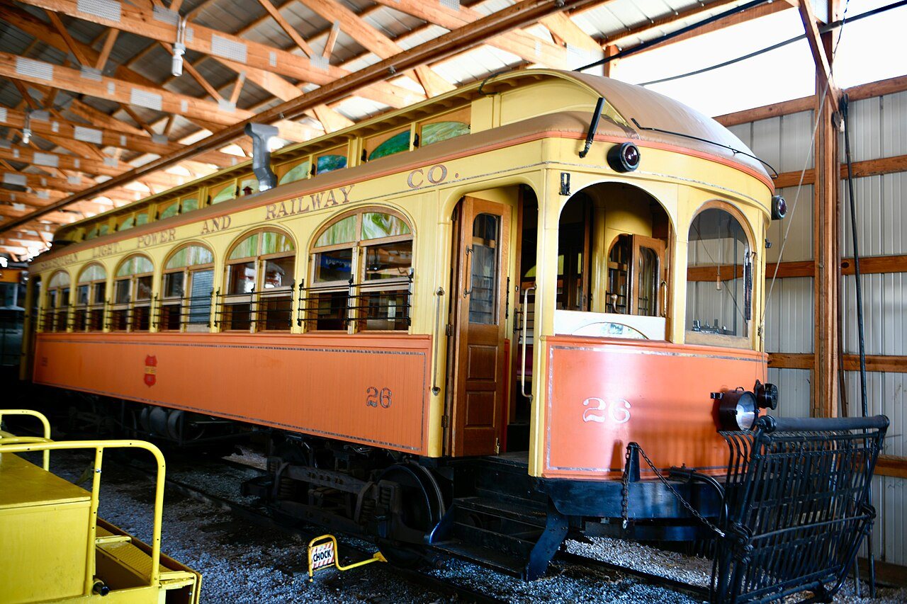
Its Register listings are the Smith and Meadows Store Buildings, the Sheboygan Light, Power and Railway Company Car #26 and the Buena Vista House. Below: 3 old photos and papers, maps from 1892 on, and the census since 1880.
Founding year: the first East Troy post office (Blevins & Helbock, CC0).
History grade
What drives East Troy’s History grade
On its age, its old homes and the National Register, East Troy is more historic than 79% of U.S. towns, #89 of 362 in Wisconsin. All 3 inputs are above most U.S. towns; its age ranks highest and its share of homes from before 1940 lowest.
A−
HistoryA character grade: shown, never part of East Troy’s overall grade.
Wisconsin towns list more on the Register than most of the country (a typical Wisconsin town has 3.0 per 10,000 residents, the U.S. 2.4), so East Troy’s 6.0 sits above most of its state (68% of Wisconsin towns have fewer) while its 3 listings outnumber those of 65% of U.S. towns.
How sure. Graded on any two of the three inputs instead, the letter would range from B+ to A−. The pre-1940 share is a Census survey estimate (±6.0 points). The founding year is the first post office, not a stated founding date.
Founding year: the first post office (other dates in Quick answers). Homes: Census ACS 2020–24. National Register: National Park Service, May 2026 list; each listing counted once (boundary changes and added documentation belong to their listing), and a historic district counts its contributing buildings. How TownRatings grades history →
What stands out about East Troy’s past
Read from the archive, the National Register and the record. The page puts what stands out first.
Every edition of the U.S. Geological Survey’s map of East Troy. Tap a year, or press play to watch the town change.
1892Eagle sheet · 1:62,500
U.S. Geological Survey historical topographic maps (public domain), via Esri’s collection of the scans. The red ring marks the center of East Troy.
Every building
East Troy, building by building, 1894–1912
Fire insurance maps drew every building, what it was made of and what it was used for, so insurers could price the risk of fire. Pick a year, then a sheet.
1894Sheet 1 of 1
Edition
Sheets
BrickWoodStone
Sanborn Map Company, via the Library of Congress. Editions published in 1930 or earlier, which are in the public domain.
The story so far
East Troy, in brief
Wikipedia doesn’t have a history of East Troy yet. The photos, dates and memories neighbors add here are how it gets written.
East Troy is a village in Walworth County, Wisconsin, United States. The population was 5,673 at the 2020 census. The village is surrounded by the Town of East Troy, with a small portion extending into the adjacent Town of Troy.
Its first post office opened in 1839. Between the 2010 and 2020 censuses its population grew from 4,281 to 4,687 (+9%).
Intro from Wikipedia. Population: U.S. Census Bureau.
From the old history books
What they wrote about East Troy, 1882–1912
Passages that mention East Troy, cut from the printed page as they were published.
History of Walworth County, Wisconsin, containing an account of its settlement, growth, development and resources...its war record, biographical sketches, portraits of prominent men and early settlers1882 · page 528Read the page →
Read the text
The fii'st settlers on the site of the present village of East Troy were 'Mi: H. Roberts, Asa Blood, Austin McCracken and Jacob Burgit. The accoimt of their settlements has already been given in the early history of the town of East Troy, as well as all the early history of the village previous to its being platted. The platting of the village occurred in March, 1847. Martin Fields, of Mukwanago doing the surveying. All that part of the village lying north of the main street, was owned and phitted by Austin McCracken, and that south of the main street by Jacob Bm'git. McCracken and Burgit, the proprietors of the village, offered special inducements to the peopling of the village by giving to each person a lot, providing he would build on this
Text read by machine from the scan; it may contain errors.
History of Walworth County, Wisconsin, containing an account of its settlement, growth, development and resources...its war record, biographical sketches, portraits of prominent men and early settlers1882 · page 529Read the page →
Read the text
The first school in the village of East Troy was taught by a Miss Auger in 1839. It was held in the Methodist Chapel, which was the first frame Ijuilding erected in the village. The first schoolhouse was built in 1846. This was a one-story frame building, in size 20x36. The present schoolhouse was built in 1853 or 1854, the old one being too small to accommodate all the school children. The old schoolhouse has been remodeled, and is now owned and used by J. Bailey as a dwelling-house. The present house is in size 34x')0, two stories high, with accommodations for about two hundred scholars. The school is gi'aded, emjiloying three teachers.
Text read by machine from the scan; it may contain errors.
History of Walworth county, Wisconsin ..1912 · page 272Read the page →
Read the text
The town of Troy, as established in 1838, included two government townships. It was divided March 21, 1843, an(l lts eastern half, town 4 north, range 18 east, became East Troy. The town of Mukwonago lies next north and the town of Waterford is next east. The slightly uneven surface of this town is generally about eight hundred and twenty-five feet above sealevel. Honey creek comes into East Troy at section 18, crosses sections 29, 28, 21, 22, 23, 24, leaves the county to return to the southeast corner of section 36, and drains the eastern part of Spring Prairie. A branch comes nut
Text read by machine from the scan; it may contain errors.
History of Walworth county, Wisconsin ..1912 · page 354Read the page →
Read the text
There is a church in section 10, at the Bishop farm, its service usually supplied from the Congregational church at East Troy, and near it is a wellkept burial ground, laid out in 1848. There are also graves at "Westville."' in section 6, and at the Seymour farm in section 18, laid out in 1844.
Text read by machine from the scan; it may contain errors.
Scans and text from the Internet Archive. Books published in 1930 or earlier, which are in the public domain.
Timeline
East Troy, 1839 to 1968
Woven from the archive, old maps, post office records, the National Register and the people born here.
Nothing in the archives for these yearsWeddings on Main Street, storms, parades, school pictures, the old store. If it’s in your family album, it belongs here.
The East Troy post office opened in 1839, the earliest record of the town by name (U.S. post office records).
How does East Troy rank for history?
East Troy is more historic than 79% of U.S. towns, #89 of 362 in Wisconsin. The History grade combines the town’s founding era, the share of homes built before 1940 and its National Register listings. It’s a character grade, so it isn’t part of the overall grade. How it works.
What is on the National Register in East Troy?
Three places: the Smith and Meadows Store Buildings (listed 1993), the Sheboygan Light, Power and Railway Company Car #26 (2006) and the Buena Vista House (1978).
How old are the homes in East Troy?
16% of East Troy’s homes were built before 1940 (Census estimate, ±6.0 points), against a typical 12% for a Wisconsin town; the median home was built in 1991.
Founding dates: Wikidata, Wikipedia, the U.S. post office records of Blevins & Helbock (CC0) and the Census. Homes by year built: Census ACS 2020–24. National Register of Historic Places: National Park Service (list of May 22, 2026). Old photos, postcards and papers: Wikimedia Commons, the Library of Congress and other public archives, credited on each item’s page. Maps: U.S. Geological Survey historical topographic maps (via Esri) and Sanborn fire-insurance maps (Library of Congress). History text and census tables: Wikipedia (CC BY-SA 4.0). Places that used to be: USGS Geographic Names Information System (2021).
From Wikimedia Commons (11), Wikidata (1), the National Register of Historic Places (3), Wikidata and Wikipedia for famous people, U.S. Geological Survey historical maps, U.S. Census counts (via Wikipedia), the US Post Offices dataset (Blevins & Helbock), the USGS Geographic Names Information System, Sanborn fire insurance maps (Library of Congress) and old county and town histories (Internet Archive). Archive images are copied here with their credits and licenses, shown on each photo’s page. Refreshed monthly.






 1933
 1933
 2026
 2026
 2026
 2024
 2019
 2014
 2014
 2006


