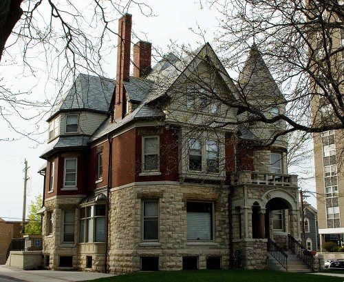
Its Register listing is the Emanuel D. Adler House. Its Register listing is the Emanuel D. Adler House. Below: maps from 1894 on and the census since 1860.
Founding year: Wikidata. First post office: 1883.The full story ↓
History grade
What drives Dodgeville’s History grade
On its age, its old homes and the National Register, Dodgeville is more historic than 85% of U.S. towns. All 3 inputs are above most U.S. towns; its share of homes from before 1940 ranks highest and its National Register listings lowest.
A
HistoryA character grade: shown, never part of Dodgeville’s overall grade.
Wisconsin towns list more on the Register than most of the country (a typical Wisconsin town has 3.0 per 10,000 residents, the U.S. 2.4), so Dodgeville’s 6.7 sits above most of its state (69% of Wisconsin towns have fewer) while its 1 listings outnumber those of 51% of U.S. towns.
NoteThe founding year comes from Wikidata alone; no second source gives 1827.
How sure. Graded on any two of the three inputs instead, the letter would range from B+ to A. The pre-1940 share is a Census survey estimate (±9.1 points).
Founding year: Wikidata (other dates in Quick answers). Homes: Census ACS 2020–24. National Register: National Park Service, May 2026 list; each listing counted once (boundary changes and added documentation belong to their listing), and a historic district counts its contributing buildings. How TownRatings grades history →
What stands out about Dodgeville’s past
Read from the archive, the National Register and the record. The page puts what stands out first.
US Post Offices dataset (Blevins & Helbock, CC0). Places and cemeteries from the USGS Geographic Names Information System (2021).
Every building
Dodgeville, building by building, 1894–1915
Fire insurance maps drew every building, what it was made of and what it was used for, so insurers could price the risk of fire. Pick a year, then a sheet.
In 1827, Henry Dodge, his family, and about 40 miners began what would become the city of Dodgeville. Dodge made a pact with the local Winnebago Indian leaders so he could build a cabin and smelter. The original community had three settlements: "Dodgeville", "Dirty Hollow" and "Minersville". A fourth settlement, Moon Spring, near the intersection of the present Highway 18 bypass and Bennett Road flourished until the cholera epidemic in the early 1850s.
Passages that mention Dodgeville, cut from the printed page as they were published.
History of Iowa County, Wisconsin, containing an account of its settlement, growth, development and resources...biographical sketches..1881 · page 751Read the page →
Read the text
In September, 1876, at a legally appointed meeting, the village and town of Dodgeville voted the handsome sum of $57,500 aid, $14,000 of which was to come from the town. This voting 5 per cent of the taxable property of the town for a railroad was highly disagreeable to a great many, and an attempt was made by the town to become separated from the village, but not successfully. The condition on which the bonds were given was that the money was not to be paid over until the work was completed, or near enough done to insure a completion.
Text read by machine from the scan; it may contain errors.
History of Iowa County, Wisconsin, containing an account of its settlement, growth, development and resources...biographical sketches..1881 · page 778Read the page →
Read the text
The Dodgeville Fire Insurance Company — Was organized March 22, 1879, in the village of Dodgeville, under the Revised Statutes of Wisconsin, providing for the organization of such institutions. The Board of Directors elected for one year, or until successors are chosen and qualified, consisted of John Rowe, Sr.. James Bennett, William T. Williams. Peter Reckenthaler, William Berryman. B. Schoeneman. T. M. Jones. H. Halgrimson and Joseph Perkins. Twenty-seven names were subscribed, repres.mting §25,000 of insured property. John Rowe, Sr., was elected President : Joseph Perkins. Secretary, and James Bennett, Treasurer. The first annual meeting was held January 6. 1880. The Treasurer's report showed that §168.55 had been
Text read by machine from the scan; it may contain errors.
Scans and text from the Internet Archive. Books published in 1930 or earlier, which are in the public domain.
Timeline
Dodgeville, 1827 to 1920
Woven from the archive, old maps, post office records, the National Register and the people born here.
In 1827, according to Wikidata. Dodgeville’s post office opened in 1883, and the census of 1860 counted 1,222 people here.
How does Dodgeville rank for history?
Dodgeville is more historic than 85% of U.S. towns. The History grade combines the town’s founding era, the share of homes built before 1940 and its National Register listings. It’s a character grade, so it isn’t part of the overall grade. How it works.
What is on the National Register in Dodgeville?
One place: the Emanuel D. Adler House (listed 1991).
How old are the homes in Dodgeville?
28% of Dodgeville’s homes were built before 1940 (Census estimate, ±9.1 points), against a typical 12% for a Wisconsin town; the median home was built in 1979.
Founding dates: Wikidata, Wikipedia, the U.S. post office records of Blevins & Helbock (CC0) and the Census. Homes by year built: Census ACS 2020–24. National Register of Historic Places: National Park Service (list of May 22, 2026). Old photos, postcards and papers: Wikimedia Commons, the Library of Congress and other public archives, credited on each item’s page. Maps: U.S. Geological Survey historical topographic maps (via Esri) and Sanborn fire-insurance maps (Library of Congress). History text and census tables: Wikipedia (CC BY-SA 4.0). Places that used to be: USGS Geographic Names Information System (2021).
From Wikimedia Commons (15), Wikidata (3), the National Register of Historic Places (1), Wikipedia, Wikidata and Wikipedia for famous people, U.S. Geological Survey historical maps, U.S. Census counts (via Wikipedia), the US Post Offices dataset (Blevins & Helbock), the USGS Geographic Names Information System, Sanborn fire insurance maps (Library of Congress) and old county and town histories (Internet Archive). Archive images are copied here with their credits and licenses, shown on each photo’s page. Refreshed monthly.


 2009
 2009
 2009
 2009
 2009
 2009
 2009
 2009
 2009
 2009
 2009
 2009
 2009
 2007
 2004