Founding year: the first Black Earth post office (Blevins & Helbock, CC0).The full story ↓
History grade
What drives Black Earth’s History grade
On its age, its old homes and the National Register, Black Earth is more historic than 64% of U.S. towns. Its National Register listings hold the grade up; its age pulls it down.
B
HistoryA character grade: shown, never part of Black Earth’s overall grade.
Wisconsin towns list more on the Register than most of the country (a typical Wisconsin town has 3.0 per 10,000 residents, the U.S. 2.4), so Black Earth’s 17.3 sits above most of its state (81% of Wisconsin towns have fewer) while its 3 historic buildings outnumber those of 65% of U.S. towns.
How sure. Graded on any two of the three inputs instead, the letter would range from B− to A−. The pre-1940 share (±2.5 points) is firm at this size. The founding year is the first post office, not a stated founding date.
Founding year: the first post office (other dates in Quick answers). Homes: Census ACS 2020–24. National Register: National Park Service, May 2026 list; each listing counted once (boundary changes and added documentation belong to their listing), and a historic district counts its contributing buildings. How TownRatings grades history →
What stands out about Black Earth’s past
Read from the archive, the National Register and the record. The page puts what stands out first.
Fire insurance maps drew every building, what it was made of and what it was used for, so insurers could price the risk of fire. Pick a year, then a sheet.
1894Sheet 1 of 1
Edition
Sheets
BrickWoodStone
Sanborn Map Company, via the Library of Congress. Editions published in 1930 or earlier, which are in the public domain.
Passages that mention Black Earth, cut from the printed page as they were published.
History of Dane County, Wisconsin ... preceded by a history of Wisconsin, statistics of the state, and an abstract of its laws and constitution and of the Constitution of the United States1880 · page 879Read the page →
A history of Madison, the capital of Wisconsin1874 · page 395Read the page →
Read the text
The village of Black Earth is one of considerable business, and is situated on section 26. It contains a grist mill, Congregational and Methodist churches, hotel, town hall, a newspaper office and a number of stores and shops. It was incorporated in 1857, which act was after¬ wards repealed. Population in 1870, 966.
Text read by machine from the scan; it may contain errors.
History of Dane County, Wisconsin ... preceded by a history of Wisconsin, statistics of the state, and an abstract of its laws and constitution and of the Constitution of the United States1880 · page 888Read the page →
Read the text
The Prairie Du Chien Division of the Chicago, Milwaukee & St. Paul Railroad passes through the town, entering at Section 36 and passing through the village of Black Earth, leaves the town at Section 22, entering into Mazomanie. The first permanent settlement made in the town was by Solomon Hayden and Charles Turk, in the spring of 1843, Mr. Hayden erecting the first house within the present town limits. It was a rude affair, such as is common to all new countries, but it was a home, and " Be it ever so humble, there's no place like home." The next settler was Henry Wilson, who came in October, 1848, of whom the story is often told, that he spent his first winter in a haystack.
Text read by machine from the scan; it may contain errors.
Madison, Dane County and surrounding towns1877 · page 592Read the page →
Read the text
This township, located in the northwest comer of the county, was formerly a part of the town of Black Earth, and comprises the north half of towiiship 8 north, of range 6 east, and fractional part of town 9, range 6, lying south and east of the Wisconsin river. The northern portion of this town bordering on the rirer, was at one time low and marshy; but now, extensive tracts have been drained and brought under cultivation,
Text read by machine from the scan; it may contain errors.
Scans and text from the Internet Archive. Books published in 1930 or earlier, which are in the public domain.
Timeline
Black Earth, 1844 to 1962
Woven from the archive, old maps, post office records, the National Register and the people born here.
Nothing in the archives for these yearsWeddings on Main Street, storms, parades, school pictures, the old store. If it’s in your family album, it belongs here.
National Park Service, National Register of Historic Places. Photos from Wikimedia Commons, credited on each place’s page.
People over time
Black Earth, census by census
Grew from 355 people in 1890 to 1,493 in 2020, 4 times over.
13 censuses, 1890–2020.
U.S. Census Bureau decennial counts, from the census table on Black Earth’s Wikipedia page.
Questions about Black Earth’s history
What year was Black Earth founded?
The Black Earth post office opened in 1850, the earliest record of the town by name (U.S. post office records).
How does Black Earth rank for history?
Black Earth is more historic than 64% of U.S. towns. The History grade combines the town’s founding era, the share of homes built before 1940 and its National Register listings. It’s a character grade, so it isn’t part of the overall grade. How it works.
What is on the National Register in Black Earth?
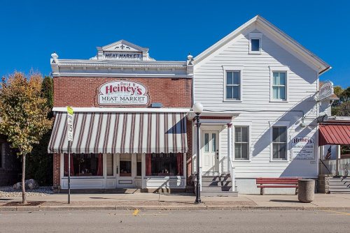
One place: the Heiney's Meat Market (listed 1984).
How old are the homes in Black Earth?
17% of Black Earth’s homes were built before 1940 (Census estimate, ±2.5 points), against a typical 12% for a Wisconsin town; the median home was built in 1977.
Founding dates: Wikidata, Wikipedia, the U.S. post office records of Blevins & Helbock (CC0) and the Census. Homes by year built: Census ACS 2020–24. National Register of Historic Places: National Park Service (list of May 22, 2026). Old photos, postcards and papers: Wikimedia Commons, the Library of Congress and other public archives, credited on each item’s page. Maps: U.S. Geological Survey historical topographic maps (via Esri) and Sanborn fire-insurance maps (Library of Congress). History text and census tables: Wikipedia (CC BY-SA 4.0). Places that used to be: USGS Geographic Names Information System (2021).
From Wikimedia Commons (10), the Library of Congress (1), Wikidata (1), the National Register of Historic Places (1), Wikipedia, Wikidata and Wikipedia for famous people, U.S. Geological Survey historical maps, U.S. Census counts (via Wikipedia), the US Post Offices dataset (Blevins & Helbock), the USGS Geographic Names Information System, Sanborn fire insurance maps (Library of Congress) and old county and town histories (Internet Archive). Archive images are copied here with their credits and licenses, shown on each photo’s page. Refreshed monthly.




 2012
 2012
 2012
 2011
 2011
 2010
 2010
 2009
 2008
 2004

