Wilkeson’s post office opened in 1877, and 59% of its homes were built before 1940
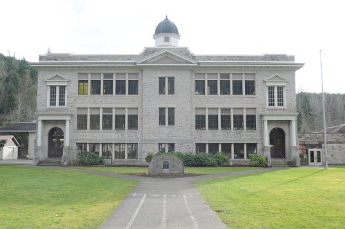
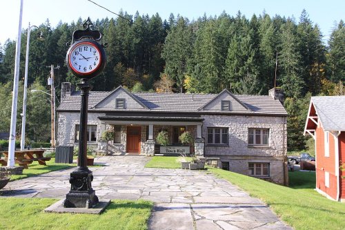
6 places in town are on the National Register, among them a historic district with 2 buildings. Below: 1 old photo or paper, maps from 1910 on, and the census since 1880.
Settlers searching for coal arrived in the area that became Wilkeson in the 1870s. By 1877, a Northern Pacific Railway line transported coal to Tacoma. Northern Pacific Railway president Henry Villard hired geologist Bailey Willis to direct field explorations of the coal fields around Wilkeson. Much of the property of Wilkeson was purchased by Northern Pacific Railway, with the remaining part of town known as Hope. In 1885, coke ovens were built by the Wilkeson Coal and Coke Company. In addition to coal, Wilkeson shipped timber and sandstone across Washington.
Wilkeson was officially incorporated on July 18, 1909. The town is named for Samuel Wilkeson, father of journalist and pioneer settler Frank Wilkeson.
Peaked at 899 in 1910; 499 people lived here in 2020.
13 censuses, 1880–2020.
U.S. Census Bureau decennial counts, from the census table on Wilkeson’s Wikipedia page.
From the old history books
What they wrote about Wilkeson in 1927
Passages that mention Wilkeson, cut from the printed page as they were published.
History of Pierce County Washington1927 · page 716Read the page →
Read the text
years in Vanderbilt University, at Nashville, Tennessee. In 1889 he came west and entered the employ of the Northern Pacific Railroad as an operator on the Pacific division, being stationed at Chehalis, Portland, and other points, remaining with that company about four years. He then came to Wilkeson and entered the office of the Wilkeson Coal & Coke Company, with which he has remained continuously since. In 1901 he was appointed general superintendent of this company, which position he has acceptably filled to the present time.
Text read by machine from the scan; it may contain errors.
History of Pierce County Washington1927 · page 531Read the page →
Read the text
again crossed the Atlantic, coming direct to Washington, and entered the mines at Carbonado, where he remained about fifteen years, during thirteen years of which time he was assistant foreman. He served as general mine foreman for the Pacific Coal & Oil Company at Spiketon about one year, and then came to Wilkeson, where he spent two years as general foreman for the Wilkeson Coal & Coke Company. In 1907 he retired from active labor and has since lived quietly in Wilkeson, enjoying well earned leisure.
Text read by machine from the scan; it may contain errors.
Scans and text from the Internet Archive. Books published in 1930 or earlier, which are in the public domain.
Timeline
Wilkeson, 1877 to 1942
Woven from the archive, old maps, post office records, the National Register and the people born here.
Nothing in the archives for these yearsWeddings on Main Street, storms, parades, school pictures, the old store. If it’s in your family album, it belongs here.
Every edition of the U.S. Geological Survey’s map of Wilkeson. Tap a year, or press play to watch the town change.
1942Lake Tapps sheet · 1:62,500
U.S. Geological Survey historical topographic maps (public domain), via Esri’s collection of the scans. The red ring marks the center of Wilkeson.
Every building
Wilkeson, building by building, 1910–1927
Fire insurance maps drew every building, what it was made of and what it was used for, so insurers could price the risk of fire. Pick a year, then a sheet.
Founding dates: Wikidata, Wikipedia, the U.S. post office records of Blevins & Helbock (CC0) and the Census. Homes by year built: Census ACS 2020–24. National Register of Historic Places: National Park Service (list of May 22, 2026). Old photos, postcards and papers: Wikimedia Commons, the Library of Congress and other public archives, credited on each item’s page. Maps: U.S. Geological Survey historical topographic maps (via Esri) and Sanborn fire-insurance maps (Library of Congress). History text and census tables: Wikipedia (CC BY-SA 4.0). Places that used to be: USGS Geographic Names Information System (2021). How TownRatings grades history →
From Wikimedia Commons (3), Wikidata (3), the National Register of Historic Places (6), Wikipedia, U.S. Geological Survey historical maps, U.S. Census counts (via Wikipedia), the US Post Offices dataset (Blevins & Helbock), the USGS Geographic Names Information System, Sanborn fire insurance maps (Library of Congress) and old county and town histories (Internet Archive). Archive images are copied here with their credits and licenses, shown on each photo’s page. Refreshed monthly.




 2011
 2008


