More historic than 28% of U.S. towns · #140 of 285 in Washington. What drives it
Most of Sultan was built recently: 10% of its homes predate 1940 and the median home dates from 2002. Below: 18 old photos and papers, maps from 1913 on, and the census since 1910.
Founding year: Wikipedia. First post office: 1894.The full story ↓
History grade
What drives Sultan’s History grade
On its age, its old homes and the National Register, Sultan is more historic than 28% of U.S. towns, #140 of 285 in Washington. Its share of homes from before 1940 holds the grade up; its National Register listings pull it down.
C
HistoryA character grade: shown, never part of Sultan’s overall grade.
Few Washington towns list much on the Register (a typical Washington town has 0.1 per 10,000 residents, the U.S. 2.4), so Sultan’s 0.0 sits below most of its state (27% of Washington towns have fewer) while its 0 listings outnumber those of 23% of U.S. towns.
How sure. Graded on any two of the three inputs instead, the letter would range from C− to C. The pre-1940 share is a Census survey estimate (±6.3 points). Two sources give 1880.
Founding year: Wikipedia (other dates in Quick answers). Homes: Census ACS 2020–24. National Register: National Park Service, May 2026 list; each listing counted once (boundary changes and added documentation belong to their listing), and a historic district counts its contributing buildings. How TownRatings grades history →
What stands out about Sultan’s past
Read from the archive, the National Register and the record. The page puts what stands out first.
Nothing in the archives for these yearsWeddings on Main Street, storms, parades, school pictures, the old store. If it’s in your family album, it belongs here.
The area around the Sultan and Skykomish rivers was occupied by the Skykomish, a branch of the Snohomish people, prior to the arrival of American settlers. The Skykomish had a permanent village at the confluence named tʷ'tsɬitɬd, along with a nearby fishery named stək'talidubc. Following the discovery of a rich gold vein along the Sultan River, the land around the confluence was claimed for a homestead by John Nailor and his wife in 1880. Among the first arrivals to the area were Chinese prospectors, who later settled the land but were evicted in 1885. Nailor built a small store and hotel to serve miners and loggers, eventually serving as the first postmaster after the settlement received a post office in 1885. The town and river were named "Sultan", an anglicization of Tseul-tud (also known as Tseul-dan), then chief of the Skykomish tribe.
Passages that mention Sultan, cut from the printed page as they were published.
History of Snohomish County, Washington, Volume I1926 · page 600Read the page →
Read the text
SULTAN Following the paths of the Great Northern Railway and the Scenic Highway up the Skykomish Valley, the next stop above Monroe is the Village of Sultan. Sultan is a town with a past, but it also has a live and energetic present. Like many other towns of the county its location was fixed by the water courses and it lies at the confluence of the Sultan with the Skykomish River. It is thus at the foot of the Sultan Basin, a stream whose golden sands have been the lure of many a prospector.
Text read by machine from the scan; it may contain errors.
History of Snohomish County, Washington, Volume I1926 · page 605Read the page →
Read the text
Sultan is justly proud of its schools. There is a union district, composed of Districts Nos. 30, 31 and 32, with a grade school at Woods Creek and at Sultan and the high school at Sultan. The Methodist Episcopal Church, established in 1892, is one of the chief places of worship under the guidance of its popular pastor, Rev. L. F. Smith. The Congregational Church, although the first organized is now temporarily without a pastor; the Catholic Church services are held somewhat irregularly, being supplied from Monroe. The Dutch Reform Church is also temporarily without a pastor.
Text read by machine from the scan; it may contain errors.
Scans and text from the Internet Archive. Books published in 1930 or earlier, which are in the public domain.
Timeline
Sultan, 1880 to 1953
Woven from the archive, old maps, post office records, the National Register and the people born here.
In 1880, according to Wikipedia’s history of the town. Sultan’s post office opened in 1894, and the census of 1910 counted 576 people here.
How does Sultan rank for history?
Sultan is more historic than 28% of U.S. towns, #140 of 285 in Washington. The History grade combines the town’s founding era, the share of homes built before 1940 and its National Register listings. It’s a character grade, so it isn’t part of the overall grade. How it works.
How old are the homes in Sultan?
10% of Sultan’s homes were built before 1940 (Census estimate, ±6.3 points), against a typical 4.3% for a Washington town; the median home was built in 2002.
Founding dates: Wikidata, Wikipedia, the U.S. post office records of Blevins & Helbock (CC0) and the Census. Homes by year built: Census ACS 2020–24. National Register of Historic Places: National Park Service (list of May 22, 2026). Old photos, postcards and papers: Wikimedia Commons, the Library of Congress and other public archives, credited on each item’s page. Maps: U.S. Geological Survey historical topographic maps (via Esri) and Sanborn fire-insurance maps (Library of Congress). History text and census tables: Wikipedia (CC BY-SA 4.0). Places that used to be: USGS Geographic Names Information System (2021).
From Wikimedia Commons (18), Wikipedia, U.S. Geological Survey historical maps, U.S. Census counts (via Wikipedia), the US Post Offices dataset (Blevins & Helbock), the USGS Geographic Names Information System, Sanborn fire insurance maps (Library of Congress) and old county and town histories (Internet Archive). Archive images are copied here with their credits and licenses, shown on each photo’s page. Refreshed monthly.


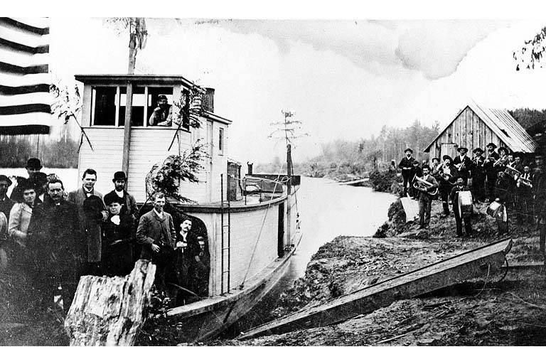

 c. 1885
 1890
 c. 1890
 c. 1891
 1892
 c. 1892
 c. 1892
 c. 1895
 c. 1895
 1896
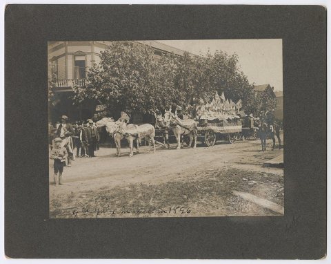 1896
 c. 1900
 c. 1912
 c. 1913
 c. 1913
 c. 1913
 c. 1913
 c. 1920


