On its age, its old homes and the National Register, Ruston is more historic than 49% of U.S. towns. Its share of homes from before 1940 holds the grade up; its age pulls it down.
B−
HistoryA character grade: shown, never part of Ruston’s overall grade.
Few Washington towns list much on the Register (a typical Washington town has 0.1 per 10,000 residents, the U.S. 2.4), so Ruston’s 8.0 sits above most of its state (82% of Washington towns have fewer) while its 1 listings outnumber those of 51% of U.S. towns.
How sure. Graded on any two of the three inputs instead, the letter would range from C to A−. The pre-1940 share is a Census survey estimate (±4.7 points). Two sources give 1906.
Founding year: Wikipedia (other dates in Quick answers). Homes: Census ACS 2020–24. National Register: National Park Service, May 2026 list; each listing counted once (boundary changes and added documentation belong to their listing), and a historic district counts its contributing buildings. How TownRatings grades history →
What stands out about Ruston’s past
Read from the archive, the National Register and the record. The page puts what stands out first.
In 1890, industrialist William R. Rust established Tacoma Smelting & Refining Company and a company town named the "Smelter District". The company took over an existing smelter that had opened two years earlier and began refining lead; it expanded to more than 300 employees by 1905, with most living in the Smelter District. In 1906, Rust proposed the creation of a new city, which residents named "Ruston" in his honor. Ruston was officially incorporated as a city on November 10, 1906, surrounded on one side by Commencement Bay and all other sides the city of Tacoma.
Passages that mention Ruston, cut from the printed page as they were published.
History of Pierce County Washington1927 · page 559Read the page →
Read the text
Ruston. With this concern, which has the largest pay roll in Tacoma, he continued until 1912, when he became assistant superintendent for Nelson Bennett, tunnel contractor. Subsequently he embarked in the grocery business, successfully conducting an enterprise of that character at Ruston for six years.
Text read by machine from the scan; it may contain errors.
History of Pierce County Washington1927 · page 124Read the page →
Read the text
the country, its plant at Ruston covering eleven acres of ground. The company owns its own clay beds and has a capacity of thirty-five thousand bricks a day, in addition to which it manufactures tile of all kinds. The selling place is one hundred and fifty by two hundred and twenty feet in size, and the company owns its own docks and railroad at 2101 Dock street. All kinds of building material are handled and the company is distributor for Cabot’s building specialties. Forty-five people are employed and the sales territory embraces all of western Washington, some of the products also going east of the mountains. The present officers of the Tacoma Brick
Text read by machine from the scan; it may contain errors.
Scans and text from the Internet Archive. Books published in 1930 or earlier, which are in the public domain.
Timeline
Ruston, 1906 to 1972
Woven from the archive, old maps, post office records, the National Register and the people born here.
Nothing in the archives for these yearsWeddings on Main Street, storms, parades, school pictures, the old store. If it’s in your family album, it belongs here.
Nothing in the archives for these yearsWeddings on Main Street, storms, parades, school pictures, the old store. If it’s in your family album, it belongs here.
In 1906, according to Wikipedia’s history of the town. the census of 1910 counted 780 people here.
How does Ruston rank for history?
Ruston is more historic than 49% of U.S. towns. The History grade combines the town’s founding era, the share of homes built before 1940 and its National Register listings. It’s a character grade, so it isn’t part of the overall grade. How it works.
What is on the National Register in Ruston?
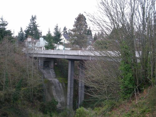
One place: the Winnifred Street Bridge (listed 1995).
How old are the homes in Ruston?
21% of Ruston’s homes were built before 1940 (Census estimate, ±4.7 points), against a typical 4.3% for a Washington town; the median home was built in 1995.
Founding dates: Wikidata, Wikipedia, the U.S. post office records of Blevins & Helbock (CC0) and the Census. Homes by year built: Census ACS 2020–24. National Register of Historic Places: National Park Service (list of May 22, 2026). Old photos, postcards and papers: Wikimedia Commons, the Library of Congress and other public archives, credited on each item’s page. Maps: U.S. Geological Survey historical topographic maps (via Esri) and Sanborn fire-insurance maps (Library of Congress). History text and census tables: Wikipedia (CC BY-SA 4.0). Places that used to be: USGS Geographic Names Information System (2021).
From Wikimedia Commons (11), Wikidata (1), the National Register of Historic Places (1), Wikipedia, U.S. Geological Survey historical maps, U.S. Census counts (via Wikipedia), the USGS Geographic Names Information System and old county and town histories (Internet Archive). Archive images are copied here with their credits and licenses, shown on each photo’s page. Refreshed monthly.




 1973
 1973
 2008
 2007
 2007
 2007
 2007
 2007
 2007


