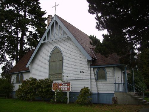
Port Angeles’ post office opened in 1862, and 17% of its homes were built before 1940
More historic than 67% of U.S. towns · #29 of 285 in Washington. What drives it
8 places in town are on the National Register, among them two historic districts with 8 buildings between them. Below: 3 old photos and papers, maps from 1891 on, and the census since 1900.
From Port Angeles’ archive · credits on each photo
Quick answers
How Port Angeles began
When was Port Angeles founded?
1862
The Port Angeles post office opened in 1862, the earliest record of the town by name. Wikidata gives 1890. Another post office, Cherburg (1861), opened inside today’s city and later closed.
First census: 2,321 in 19002020 census: 19,960164 years
How historic is Port Angeles?
B+
More historic than 67% of U.S. towns, on its age, its old homes and the National Register.
Founding year: the first Port Angeles post office (Blevins & Helbock, CC0). Wikidata: 1890.The full story ↓
History grade
What drives Port Angeles’ History grade
On its age, its old homes and the National Register, Port Angeles is more historic than 67% of U.S. towns, #29 of 285 in Washington. Its National Register listings hold the grade up; its age pulls it down.
B+
HistoryA character grade: shown, never part of Port Angeles’ overall grade.
Few Washington towns list much on the Register (a typical Washington town has 0.1 per 10,000 residents, the U.S. 2.4), so Port Angeles’ 7.0 sits above most of its state (80% of Washington towns have fewer) while its 14 historic buildings outnumber those of 78% of U.S. towns.
How sure. Graded on any two of the three inputs instead, the letter would range from B− to A−. The pre-1940 share (±2.1 points) is firm at this size. The founding year is the first post office, not a stated founding date; Wikidata’s 1890 falls in the same era, so the grade doesn’t depend on which one is used.
Founding year: the first post office (other dates in Quick answers). Homes: Census ACS 2020–24. National Register: National Park Service, May 2026 list; each listing counted once (boundary changes and added documentation belong to their listing), and a historic district counts its contributing buildings. How TownRatings grades history →
What stands out about Port Angeles’ past
Read from the archive, the National Register and the record. The page puts what stands out first.
Lost post offices, old corners, places now gone and burying grounds
Port Angeles’s post office has been open since 1862. Another post office, Cherburg, opened and closed inside today’s town.
Cherburg
1861–1862
Port Angeles
1862–today
18601940today
Hamlets and corners on the map
Cedar Glen Mobile Home ParkCedar Hills Mobile Home ParkFirwest Mobile Home ParkOcean View Mobile Home ParkWelcome Inn Trailer Court
Gone or out of use
Ediz Hook LighthouselocalePort Angeles Army Air Fieldmilitary
1cemetery inside Port Angeles
Ocean View
US Post Offices dataset (Blevins & Helbock, CC0). Places and cemeteries from the USGS Geographic Names Information System (2021).
Every building
Port Angeles, building by building, 1891–1924
Fire insurance maps drew every building, what it was made of and what it was used for, so insurers could price the risk of fire. Pick a year, then a sheet.
1891Sheet 1 of 1
Edition
Sheets
BrickWoodStone
Sanborn Map Company, via the Library of Congress. Editions published in 1930 or earlier, which are in the public domain.
This area was long occupied by succeeding cultures of indigenous peoples. In 1791, the harbor was entered by Spanish explorer Francisco de Eliza, who named it Puerto de Nuestra Señora de los Ángeles (Port of Our Lady of the Angels), claiming it for Spain. He was on an expedition from southern California. This name was shortened to the current one of Port Angeles.
It was not until the 19th century that European Americans began to settle here. A small whaling, fishing and shipping village developed, which traded with Victoria, British Columbia. In 1856–57, the first settlers arrived and were followed by the Cherbourg Land Company in 1859.
Nothing in the archives for these yearsWeddings on Main Street, storms, parades, school pictures, the old store. If it’s in your family album, it belongs here.
Nothing in the archives for these yearsWeddings on Main Street, storms, parades, school pictures, the old store. If it’s in your family album, it belongs here.
The Port Angeles post office opened in 1862, the earliest record of the town by name (U.S. post office records). Wikidata gives 1890.
How does Port Angeles rank for history?
Port Angeles is more historic than 67% of U.S. towns, #29 of 285 in Washington. The History grade combines the town’s founding era, the share of homes built before 1940 and its National Register listings. It’s a character grade, so it isn’t part of the overall grade. How it works.
What is on the National Register in Port Angeles?
8 listings: 6 buildings, among them the U.S. Post Office (listed 1983, the first), and 2 historic districts, the Olympic National Park Headquarters Historic District and the Port Angeles Civic Historic District, with 8 contributing buildings. 14 historic buildings in all.
How old are the homes in Port Angeles?
17% of Port Angeles’ homes were built before 1940 (Census estimate, ±2.1 points), against a typical 4.3% for a Washington town; the median home was built in 1968.
Founding dates: Wikidata, Wikipedia, the U.S. post office records of Blevins & Helbock (CC0) and the Census. Homes by year built: Census ACS 2020–24. National Register of Historic Places: National Park Service (list of May 22, 2026). Old photos, postcards and papers: Wikimedia Commons, the Library of Congress and other public archives, credited on each item’s page. Maps: U.S. Geological Survey historical topographic maps (via Esri) and Sanborn fire-insurance maps (Library of Congress). History text and census tables: Wikipedia (CC BY-SA 4.0). Places that used to be: USGS Geographic Names Information System (2021).
From Wikimedia Commons (2), the Library of Congress (3), Wikidata (1), the National Register of Historic Places (8), Wikipedia, Wikidata and Wikipedia for famous people, U.S. Geological Survey historical maps, U.S. Census counts (via Wikipedia), the US Post Offices dataset (Blevins & Helbock), the USGS Geographic Names Information System and Sanborn fire insurance maps (Library of Congress). Archive images are copied here with their credits and licenses, shown on each photo’s page. Refreshed monthly.




 2010
 2010