More historic than 23% of U.S. towns · #168 of 285 in Washington. What drives it
Most of Gold Bar was built recently: 6% of its homes predate 1940 and the median home dates from 1994. Below: 18 old photos and papers, maps from 1914 on, and the census since 1920.
Founding year: the first Gold Bar post office (Blevins & Helbock, CC0).The full story ↓
History grade
What drives Gold Bar’s History grade
On its age, its old homes and the National Register, Gold Bar is more historic than 23% of U.S. towns, #168 of 285 in Washington. Its age holds the grade up; its National Register listings pull it down.
C−
HistoryA character grade: shown, never part of Gold Bar’s overall grade.
Few Washington towns list much on the Register (a typical Washington town has 0.1 per 10,000 residents, the U.S. 2.4), so Gold Bar’s 0.0 sits below most of its state (27% of Washington towns have fewer) while its 0 listings outnumber those of 23% of U.S. towns.
How sure. Graded on any two of the three inputs instead, the letter would range from C− to C. The pre-1940 share is a Census survey estimate (±4.1 points). The founding year is the first post office, not a stated founding date.
Founding year: the first post office (other dates in Quick answers). Homes: Census ACS 2020–24. National Register: National Park Service, May 2026 list; each listing counted once (boundary changes and added documentation belong to their listing), and a historic district counts its contributing buildings. How TownRatings grades history →
What stands out about Gold Bar’s past
Read from the archive, the National Register and the record. The page puts what stands out first.
Nothing in the archives for these yearsWeddings on Main Street, storms, parades, school pictures, the old store. If it’s in your family album, it belongs here.
The ancestral home of the indigenous Skykomish people (sq̓ixʷəbš) was in the upper Skykomish Valley east of modern-day Sultan and including the drainage basins of the Sultan and Wallace rivers. They had a permanent village at the confluence of the Skykomish and Wallace rivers, where modern-day Gold Bar lies, named 'xaitəd. The village had a large potlatch house, built to accommodate a number of travelers, and a cemetery; it had an estimated population of 40 families in the late 19th century, representing approximately 240 people. 'xaitəd was used as a base camp for travelers coming to the area to hunt elk in the Sultan River basin. The Skykomish were a signatory party of the 1855 Treaty of Point Elliott and assigned to the Tulalip Indian Reservation at the mouth of the Snohomish River. Many members of the tribe remained in the Skykomish Valley, with as many as 320 non-reservation reside…
Passages that mention Gold Bar, cut from the printed page as they were published.
History of Snohomish County, Washington, Volume I1926 · page 608Read the page →
Read the text
Gold Bar is situated farther up the valley, between Startup and Index. It was formerly the location of extensive railroad shops, and considerable side tracks are now maintained there by the Great Northern. The Wallace Falls Timber Company operates a camp in this locality. A state fish hatchery is also conducted in the vicinity, being one of the three state hatcheries located in the county. There is a postoffice, and ample business establishments to serve the community. Gold Bar has seen several disastrous fires in the past decade.
Text read by machine from the scan; it may contain errors.
Scans and text from the Internet Archive. Books published in 1930 or earlier, which are in the public domain.
Timeline
Gold Bar, 1899 to 1957
Woven from the archive, old maps, post office records, the National Register and the people born here.
The Gold Bar post office opened in 1899, the earliest record of the town by name (U.S. post office records).
How does Gold Bar rank for history?
Gold Bar is more historic than 23% of U.S. towns, #168 of 285 in Washington. The History grade combines the town’s founding era, the share of homes built before 1940 and its National Register listings. It’s a character grade, so it isn’t part of the overall grade. How it works.
How old are the homes in Gold Bar?
6% of Gold Bar’s homes were built before 1940 (Census estimate, ±4.1 points), against a typical 4.3% for a Washington town; the median home was built in 1994.
Founding dates: Wikidata, Wikipedia, the U.S. post office records of Blevins & Helbock (CC0) and the Census. Homes by year built: Census ACS 2020–24. National Register of Historic Places: National Park Service (list of May 22, 2026). Old photos, postcards and papers: Wikimedia Commons, the Library of Congress and other public archives, credited on each item’s page. Maps: U.S. Geological Survey historical topographic maps (via Esri) and Sanborn fire-insurance maps (Library of Congress). History text and census tables: Wikipedia (CC BY-SA 4.0). Places that used to be: USGS Geographic Names Information System (2021).
From Wikimedia Commons (18), Wikipedia, U.S. Geological Survey historical maps, U.S. Census counts (via Wikipedia), the US Post Offices dataset (Blevins & Helbock), the USGS Geographic Names Information System, Sanborn fire insurance maps (Library of Congress) and old county and town histories (Internet Archive). Archive images are copied here with their credits and licenses, shown on each photo’s page. Refreshed monthly.


 1907
 c. 1910
 c. 1910
 c. 1910
 c. 1910
 c. 1910
 c. 1910
 1911
 1911
 c. 1911
 c. 1911
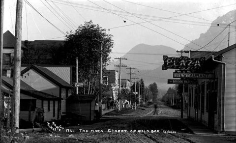 c. 1911
 c. 1911
 1911
 c. 1912
 1913
 c. 1913
 c. 1913


