


The story so far
Rutland, in brief
Wikipedia doesn’t have a history of Rutland yet. The photos, dates and memories neighbors add here are how it gets written.
Between the 2010 and 2020 censuses its population fell from 16,495 to 15,807 (-4%).
Each edition grades its towns against each other only.
More historic than 98% of U.S. towns · #13 of 71 in Vermont. What drives it
12 places in town are on the National Register, among them two historic districts with 177 buildings between them. Below: 12 old photos and papers, maps from 1879 on, and old-book passages.
More historic than 98% of U.S. towns, on its age, its old homes and the National Register.
On its age, its old homes and the National Register, Rutland is more historic than 98% of U.S. towns, #13 of 71 in Vermont. All 2 inputs are above most U.S. towns; its share of homes from before 1940 ranks highest and its National Register listings lowest.
Vermont towns list more on the Register than most of the country (a typical Vermont town has 147 per 10,000 residents, the U.S. 2.4), so Rutland’s 129 sits near the middle of its state (62% of Vermont towns have fewer) while its 202 historic buildings outnumber those of 93% of U.S. towns.
Founding year: our sources. Homes: Census ACS 2020–24. National Register: National Park Service, May 2026 list; each listing counted once (boundary changes and added documentation belong to their listing), and a historic district counts its contributing buildings. How TownRatings grades history →
Read from the archive, the National Register and the record. The page puts what stands out first.
The country’s official list of buildings and places worth saving.
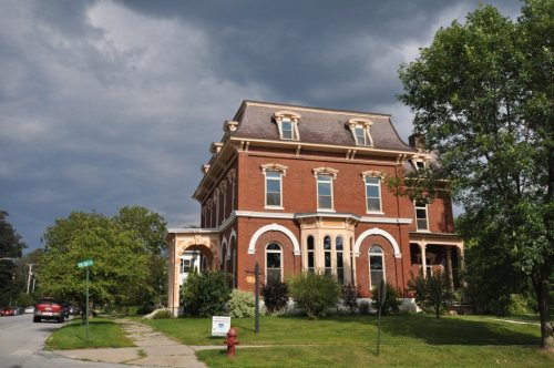
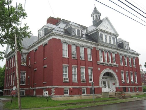


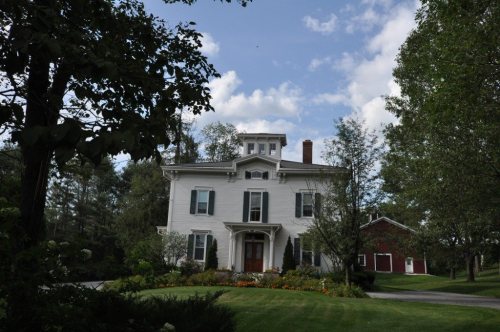


National Park Service, National Register of Historic Places. Photos from Wikimedia Commons, credited on each place’s page.
Every edition of the U.S. Geological Survey’s map of Rutland. Tap a year, or press play to watch the town change.

U.S. Geological Survey historical topographic maps (public domain), via Esri’s collection of the scans. The red ring marks the center of Rutland.
Fire insurance maps drew every building, what it was made of and what it was used for, so insurers could price the risk of fire. Pick a year, then a sheet.
 1879Sheet 1 of 5
Sanborn Map Company, via the Library of Congress. Editions published in 1930 or earlier, which are in the public domain.
Wikipedia doesn’t have a history of Rutland yet. The photos, dates and memories neighbors add here are how it gets written.
Between the 2010 and 2020 censuses its population fell from 16,495 to 15,807 (-4%).
Passages that mention Rutland, cut from the printed page as they were published.

In the year I 886 residents of the western part of the town of Rutland asked the General Assembly to set them off as a town by themselves, and a similar request was made by the citizens of the northern part of the town. After prolonged hearings, the Legislature, November 19, 1886, set off and incorporated as the town of West Rutland, about one third of the town of Rutland on the west side, and by an act approved November 18, 1886, set off from the north portion some six square miles which, together with a small amount taken from the town of Pittsford, was incorporated as the town of Proctor.
Text read by machine from the scan; it may contain errors.
"At a special meeting of the legal voters of the village of Rutland, held February 20, 1867, a vote was passed whereby all the school districts in said village were consolidated into one district, to be called the Rutland Graded School, which vote was legalized by the Legislature of Vermont, ATarch 28, 1867 ; and on the 9th day of April following, at an adjourned meeting of the voters of said village of Rutland, the organization of the graded school district was completed by the choice of officers of said district."
Text read by machine from the scan; it may contain errors.
and in that direction to the east side of the highway first mentioned; thence to the first mentioned bounds, shall hereafter be known by the name of the village of Rutland, and the inhabitants of said village are hereby constituted a body politic and corporate with the usual powers incident to public corporations, to be known by the name of the village of Rutland."
Text read by machine from the scan; it may contain errors.
The era of railroads in Rutland county, which may be said to date from about 1850, worked immediate and tremendous changes; especially was this true of the town of Rutland and the village of the same name. It is doubtful if there is another town, possibly county, in the State that was changed so universally from an inland agricultural district, without rapid communication with the outside world, to a great railroad center by the construction of the lines described, all of which were put in operation within a very short period. The village of Rutland, the commercial metropolis of the county, awakened from its
Text read by machine from the scan; it may contain errors.Scans and text from the Internet Archive. Books published in 1930 or earlier, which are in the public domain.
Woven from the archive, old maps, post office records, the National Register and the people born here.
 In the archiveRueben Thrall to Edward Bangs, 18 July 1828 - DPLA - 9987551bb7ac2c4fb25357d3484b7df5 (pa…
 In the archiveView near
 In the archiveRutland Falls, Vermont
 In the archiveMuddy Pond Rutland VT May 1861 or 1862
 In the archiveLiving, Healthy & Beautiful. Rosa & Mary, The Wonderful Canadian Double-Headed BabyBuiltBaxter, H. H., Memorial Library is built
 On the mapFirst mapped by the U.S. Geological Survey
 BuiltWatkins School is built
 In the archiveCentre Street
 BuiltLinden Terrace is builtBuiltArthur Perkins House is built
6 decades in the archive, from the 1820s to the 1890s. Scroll each row; tap a photo for its story.
No then-and-now pairs yet. Take a photo from the same spot as an old one and they appear here side by side.

Find the spot, match the angle, and add your photo. It becomes the first then-and-now pair on Rutland’s page.
Retake this view · +15Nobody well known was born in Rutland itself, so here are the best known from just nearby.


Rutland’s post office has been open since 1784.
US Post Offices dataset (Blevins & Helbock, CC0). Places and cemeteries from the USGS Geographic Names Information System (2021).
Most archives stop around 1920. The photos from after that are in family albums, not libraries.
Rutland is more historic than 98% of U.S. towns, #13 of 71 in Vermont. The History grade combines the town’s founding era, the share of homes built before 1940 and its National Register listings. It’s a character grade, so it isn’t part of the overall grade. How it works.
12 listings: 10 buildings and 2 historic districts, the Rutland Courthouse Historic District and the Rutland Downtown Historic District, with 177 contributing buildings. 202 historic buildings in all.
50% of Rutland’s homes were built before 1940 (Census estimate, ±4.6 points), against a typical 22% for a Vermont town; the median home was built in 1938.
What the archives can’t tell you, neighbors can.
Founding dates: Wikidata, Wikipedia, the U.S. post office records of Blevins & Helbock (CC0) and the Census. Homes by year built: Census ACS 2020–24. National Register of Historic Places: National Park Service (list of May 22, 2026). Old photos, postcards and papers: Wikimedia Commons, the Library of Congress and other public archives, credited on each item’s page. Maps: U.S. Geological Survey historical topographic maps (via Esri) and Sanborn fire-insurance maps (Library of Congress). History text and census tables: Wikipedia (CC BY-SA 4.0). Places that used to be: USGS Geographic Names Information System (2021).
From Wikimedia Commons (12), the National Register of Historic Places (12), U.S. Geological Survey historical maps, the US Post Offices dataset (Blevins & Helbock), the USGS Geographic Names Information System, Sanborn fire insurance maps (Library of Congress) and old county and town histories (Internet Archive). Archive images are copied here with their credits and licenses, shown on each photo’s page. Refreshed monthly.
 1865
 1898
 1898
 1898
 1898
 1898