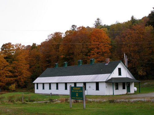
Roxbury dates to 1781, and 32% of its homes were built before 1940
1 place in town is on the National Register, among them a historic district with 5 buildings. Below: 2 old photos and papers, maps from 1924 on, and the census since 1800.
Roxbury was granted by the Vermont General Assembly in 1781; its name is likely derived from Roxbury, Massachusetts, which later became part of Boston. The town was chartered on August 6, 1781, to Benjamin Edwards and 64 other people, although just 20 of these ever lived in the town. Actual European settlement began in 1789, and the first town meeting was held in 1797.
The town grew steadily in the first six decades of the 19th century, growing from 113 residents in 1800 to a peak of 1,060 residents in 1860, on the eve of the American Civil War. In the war, 94 Roxbury men served; 29 perished. The town's population dropped in the 20th century after World War II, especially after the town's marble quarries (which opened in 1857) were closed in
Passages that mention Roxbury, cut from the printed page as they were published.
The history of the towns of Plainfield, Roxbury and Fayston, Vermont1882 · page 762Read the page →
Read the text
Doubtless ihe tract of land now known as the town of Roxbury was never the permanent home of the Indians. Yet it may be inferred from the geographical position of this portion nf our State, tint the Indians, in their predatory excursions against the colonial settlements of New England, passed through here. The Iro-
Text read by machine from the scan; it may contain errors.
The history of the towns of Plainfield, Roxbury and Fayston, Vermont1882 · page 765Read the page →
Read the text
When in print so far as with Middlesex, we had no certain historian for Roxbury engaged, but learning by chance correspondence that Mrs. Sarah Brigham Mansfield was residing at Roxbury, made her a visit with much confidence, we had found the best person in the town to write out the historic record of Roxbury. While
Text read by machine from the scan; it may contain errors.
The History of Washington County in the Vermont historical gazetteer1882 · page 761Read the page →
Read the text
96 manufacturing business, and another one was well under way here when I came from Roxbury. Stephen Butterfield has been station agent and telegraph operator nearly the whole time since the railroad came to Roxbury. E. N. Spalding is a prominent business man; dealing heavily in
Text read by machine from the scan; it may contain errors.
The history of Washington county, in the Vermont historical gazetteer1882 · page 761Read the page →
Read the text
96 manufacturing business, and another one was well under way here yvhen I came from Roxbury. Stephen Butterfield has been station agent and telegraph operator nearly the whole time since the railroad came to Roxbury. E. N. Spalding is a prominent business man, dealing heavily in
Text read by machine from the scan; it may contain errors.
Scans and text from the Internet Archive. Books published in 1930 or earlier, which are in the public domain.
By decade
Roxbury, decade by decade
One decade in the archive so far: the 1970s. Scroll each row; tap a photo for its story.
Nothing in the archives for these yearsWeddings on Main Street, storms, parades, school pictures, the old store. If it’s in your family album, it belongs here.
In 1781, according to Wikidata and Wikipedia’s history of the town. Roxbury’s post office opened in 1828, and the census of 1800 counted 113 people here.
What is on the National Register in Roxbury?
One place: the Roxbury Fish Hatchery (listed 1994).
Founding dates: Wikidata, Wikipedia, the U.S. post office records of Blevins & Helbock (CC0) and the Census. Homes by year built: Census ACS 2020–24. National Register of Historic Places: National Park Service (list of May 22, 2026). Old photos, postcards and papers: Wikimedia Commons, the Library of Congress and other public archives, credited on each item’s page. Maps: U.S. Geological Survey historical topographic maps (via Esri) and Sanborn fire-insurance maps (Library of Congress). History text and census tables: Wikipedia (CC BY-SA 4.0). Places that used to be: USGS Geographic Names Information System (2021). How TownRatings grades history →
From Wikimedia Commons (5), the National Register of Historic Places (1), Wikipedia, Wikidata and Wikipedia for famous people, U.S. Geological Survey historical maps, U.S. Census counts (via Wikipedia), the US Post Offices dataset (Blevins & Helbock), the USGS Geographic Names Information System and old county and town histories (Internet Archive). Archive images are copied here with their credits and licenses, shown on each photo’s page. Refreshed monthly.


 1974
 2014
 2010
 2004