Norwich dates to 1761, and 21% of its homes were built before 1940
More historic than 96% of U.S. towns · #18 of 71 in Vermont. What drives it
11 places in town are on the National Register, among them five historic districts with 170 buildings between them. Below: 2 old photos and papers, maps from 1906 on, and the census since 1790.
Founding year: Wikidata. First post office: 1805.The full story ↓
History grade
What drives Norwich’s History grade
On its age, its old homes and the National Register, Norwich is more historic than 96% of U.S. towns, #18 of 71 in Vermont. All 3 inputs are above most U.S. towns; its age ranks highest and its share of homes from before 1940 lowest.
A+
HistoryA character grade: shown, never part of Norwich’s overall grade.
Vermont towns list more on the Register than most of the country (a typical Vermont town has 147 per 10,000 residents, the U.S. 2.4), so Norwich’s 511 sits above most of its state (86% of Vermont towns have fewer) while its 186 historic buildings outnumber those of 93% of U.S. towns.
NoteThe founding year comes from Wikidata alone; no second source gives 1761.
How sure. Graded on any two of the three inputs instead, the letter would range from A to A+. The pre-1940 share is a Census survey estimate (±7.1 points).
Founding year: Wikidata (other dates in Quick answers). Homes: Census ACS 2020–24. National Register: National Park Service, May 2026 list; each listing counted once (boundary changes and added documentation belong to their listing), and a historic district counts its contributing buildings. How TownRatings grades history →
What stands out about Norwich’s past
Read from the archive, the National Register and the record. The page puts what stands out first.
The boundaries of Norwich were established on July 4, 1761, when Governor Benning Wentworth of New Hampshire defined the boundaries of townships in Vermont. The first settlers reached the area in 1763 and began to clear the wilderness and erect the first hand-hewn log buildings, wintering over for the first time in 1765. Early settlements occurred along the Ompompanoosuc River. Later, the current village site became settled. The first town meeting occurred in April 1768. The first Congregational church was founded in 1770 and a structure built in 1778. The population grew from 206 in 1771 to 1,158 in 1791 and 2,316 in 1830.
The town of Norwich does not appear to have been at all suited with the project of building a toll bridge. At its annual town meeting, March 8, 1796, it was voted unanimously, "that we wish there might be a free bridge built over the river Connecticut at the ferry at Doctor Lewis ' ; and in case we cannot have a free Bridge built there, we rather have a ferry kept there than to have a toll bridge built. ' ' A committee, *The Lyman Bridge between Hartford and Lebanon was commenced in 1797 and completed in 1802 ; that between Fairlee and Orford the same year ; between Newbury
Text read by machine from the scan; it may contain errors.
Of the little settlements in the township of Norwich which seem to be existing in the sunset of their former glory, may be mentioned Beaver Meadow, or West Norwich. This place presents a notable instance of that decline in population and decay of business interests in a rural commimity, of which Vermont affords many examples since the advent of railroads and the fever of western emigration set in.
Text read by machine from the scan; it may contain errors.
History of Windsor county, Vermont1891 · page 483Read the page →
Read the text
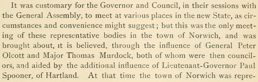
It was customary for the Governor and Council, in their sessions with the General Assembly, to meet at various places in the new State, as circumstances and convenience might suggest; but this was the only meeting of these representative bodies in the town of Norwich, and was brought about, it is believed, through the influence of General Peter Olcott and Major Thomas Murdock, both of whom were then councilors, and aided by the additional influence of Lieutenant-Governor Paul Spooner, of Hartland. At that time the town of Norwich was repre-
Text read by machine from the scan; it may contain errors.
History of Windsor County, Vermont, with illustrations and biographical sketches of some of its prominent men and pioneers1891 · page 483Read the page →
Read the text
It was customary for the Governor and Council, in their sessions with the General Assembly, to meet at various places in the new State, as circumstances and convenience might suggest; but this was the only meeting of these representative bodies in the town of Norwich, and was brougiit about, it is believed, through the influence of General Peter Olcott and Major Thomas Murdock, both of whom were then councilors, and aided by the additional influence of Lieutenant-Governor Paul Spooner, of Hartland. At that time the town of Norwich was repre-
Text read by machine from the scan; it may contain errors.
Scans and text from the Internet Archive. Books published in 1930 or earlier, which are in the public domain.
Timeline
Norwich, 1761 to 2020
Woven from the archive, old maps, post office records, the National Register and the people born here.
In 1761, according to Wikidata. Norwich’s post office opened in 1805, and the first U.S. census counted 1,158 people here in 1790.
How does Norwich rank for history?
Norwich is more historic than 96% of U.S. towns, #18 of 71 in Vermont. The History grade combines the town’s founding era, the share of homes built before 1940 and its National Register listings. It’s a character grade, so it isn’t part of the overall grade. How it works.
What is on the National Register in Norwich?
11 listings: 6 buildings and 5 historic districts with 170 contributing buildings. 186 historic buildings in all.
How old are the homes in Norwich?
21% of Norwich’s homes were built before 1940 (Census estimate, ±7.1 points), against a typical 22% for a Vermont town; the median home was built in 1982.
Founding dates: Wikidata, Wikipedia, the U.S. post office records of Blevins & Helbock (CC0) and the Census. Homes by year built: Census ACS 2020–24. National Register of Historic Places: National Park Service (list of May 22, 2026). Old photos, postcards and papers: Wikimedia Commons, the Library of Congress and other public archives, credited on each item’s page. Maps: U.S. Geological Survey historical topographic maps (via Esri) and Sanborn fire-insurance maps (Library of Congress). History text and census tables: Wikipedia (CC BY-SA 4.0). Places that used to be: USGS Geographic Names Information System (2021).
From Wikimedia Commons (3), Wikidata (1), the National Register of Historic Places (11), Wikipedia, Wikidata and Wikipedia for famous people, U.S. Geological Survey historical maps, U.S. Census counts (via Wikipedia), the US Post Offices dataset (Blevins & Helbock), the USGS Geographic Names Information System and old county and town histories (Internet Archive). Archive images are copied here with their credits and licenses, shown on each photo’s page. Refreshed monthly.




 2004


