The name derives from a word from a Native American language that means "land between two waters." Nassawadox is bounded on the east by the Atlantic Ocean and on the west by the Chesapeake Bay. The county is divided, as is the town, into bayside and seaside areas, which refer to the land on either side of the highway, Route 13 (Lankford Highway), which runs through Accomack and Northampton counties.
Highlighting its name and its location, Nassawadox has since 1993 hosted the annual October Between the Waters Bike Tour, which features bike tours of various lengths between the Eastern Shore's two coasts.
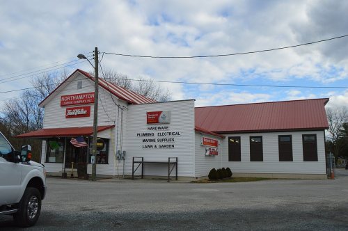
Brownsville and the Northampton Lumber Company Historic District are listed on the National Register of Historic Places.
Nothing in the archives for these yearsWeddings on Main Street, storms, parades, school pictures, the old store. If it’s in your family album, it belongs here.
Founding dates: Wikidata, Wikipedia, the U.S. post office records of Blevins & Helbock (CC0) and the Census. Homes by year built: Census ACS 2020–24. National Register of Historic Places: National Park Service (list of May 22, 2026). Old photos, postcards and papers: Wikimedia Commons, the Library of Congress and other public archives, credited on each item’s page. Maps: U.S. Geological Survey historical topographic maps (via Esri) and Sanborn fire-insurance maps (Library of Congress). History text and census tables: Wikipedia (CC BY-SA 4.0). Places that used to be: USGS Geographic Names Information System (2021). How TownRatings grades history →
From the Library of Congress (6), the National Register of Historic Places (1), Wikipedia, Wikidata and Wikipedia for famous people, the US Post Offices dataset (Blevins & Helbock) and the USGS Geographic Names Information System. Archive images are copied here with their credits and licenses, shown on each photo’s page. Refreshed monthly.


 1930
 1930
 1930
 1930
 1930